


TransCanadaHighway.com
@transcanadahighway.com
Canadian travel & tourism information for travelers across ALL provinces and all cities, with great highway itineraries! What to see and do along Canada's national highway! Latest weather and highway closures. https://TransCanadaHighway.com
Pinned

Watch here for the latest in weather and highway conditions/closures. Please follow us or bookmark this page!
BC: Snowfall ( 30-40cm) along Coquihalla Highway #5 and Coquihalla Summit starting later this evening and easing late Saturday night.

December 5, 2025 at 11:00 PM
BC: Snowfall ( 30-40cm) along Coquihalla Highway #5 and Coquihalla Summit starting later this evening and easing late Saturday night.
BC: Snowfall (15 to 20 cm) along Trans-Canada Highway #1 from Sicamous to Revelstoke from midday Friday to late Saturday morning.

December 5, 2025 at 2:14 PM
BC: Snowfall (15 to 20 cm) along Trans-Canada Highway #1 from Sicamous to Revelstoke from midday Friday to late Saturday morning.
ON: Persistent snow squalls (25 to 40 cm) along Trans-Canada #17 and #11 between Thunder Bay and North Bay.


December 4, 2025 at 9:08 PM
ON: Persistent snow squalls (25 to 40 cm) along Trans-Canada #17 and #11 between Thunder Bay and North Bay.
ON: Snow (10-15 cm) and blowing snow along Trans-Canada #17 and 11 from ON/MB border to Thunder Bay this afternoon through tonight


December 4, 2025 at 8:47 PM
ON: Snow (10-15 cm) and blowing snow along Trans-Canada #17 and 11 from ON/MB border to Thunder Bay this afternoon through tonight
NS: The Cobequid Pass on Trans-Canada #104 is currently at a standstill right now. Recommend: pull off either in Thompson Station or Glenholme to relax and allow crews to clear highway


December 3, 2025 at 1:40 PM
NS: The Cobequid Pass on Trans-Canada #104 is currently at a standstill right now. Recommend: pull off either in Thompson Station or Glenholme to relax and allow crews to clear highway
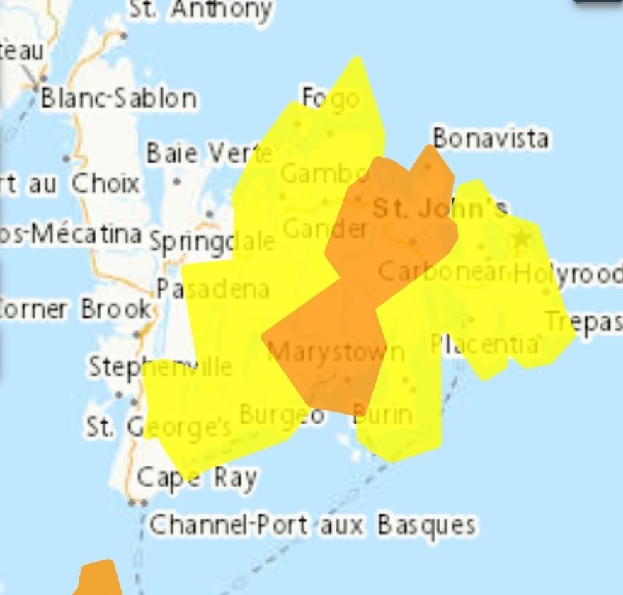
NL: Snowfall (30 to 40 cm) with wind gusts (northeasterly 80 to 100 km/h) along TCH #1 in central and eastern Newfoundland until late this evening. Up to 50 cm in Clarenville area.

December 3, 2025 at 1:32 PM
NL: Snowfall (30 to 40 cm) with wind gusts (northeasterly 80 to 100 km/h) along TCH #1 in central and eastern Newfoundland until late this evening. Up to 50 cm in Clarenville area.
AB: Near zero visibility in fog along Trans-Canada #1 around Gleichen, east of Calgary. The fog is expected to dissipate this morning.
If driving, turn on your lights, slow down and maintain a safe following distance.
If driving, turn on your lights, slow down and maintain a safe following distance.

December 3, 2025 at 1:23 PM
AB: Near zero visibility in fog along Trans-Canada #1 around Gleichen, east of Calgary. The fog is expected to dissipate this morning.
If driving, turn on your lights, slow down and maintain a safe following distance.
If driving, turn on your lights, slow down and maintain a safe following distance.
ON:Delays on Highway 417 through Ottawa around the Vanier Parkway this weekend due to watermain repairs to a valve located on the highway will close 3 westbound lanes both westbound on-ramps from the Vanier Parkway to Hwy. 417.

November 26, 2025 at 3:36 PM
ON:Delays on Highway 417 through Ottawa around the Vanier Parkway this weekend due to watermain repairs to a valve located on the highway will close 3 westbound lanes both westbound on-ramps from the Vanier Parkway to Hwy. 417.
ON: Snow squalls (15 to 30 cm) along Highway 401 from Windsor to Montreal Thursday morning into Saturday.

November 26, 2025 at 3:10 AM
ON: Snow squalls (15 to 30 cm) along Highway 401 from Windsor to Montreal Thursday morning into Saturday.
ON: Heavy snow (25 to 40 cm) and hazardous winter conditions along Trans-Canada #17 from Thunder Bay to Sault Ste Marie and Northern Route #11 from Thunder Bay to North Bay beginning Tuesday night and moving west to east through to Thursday.

November 24, 2025 at 10:44 PM
ON: Heavy snow (25 to 40 cm) and hazardous winter conditions along Trans-Canada #17 from Thunder Bay to Sault Ste Marie and Northern Route #11 from Thunder Bay to North Bay beginning Tuesday night and moving west to east through to Thursday.
AB: Heavy snow (10 to 20 cm) along Crowsnest Highway #3 between Fernie snd Fort MacLeod on Monday, beginning late tonight and intensify on Monday, ending Monday evening.
November 23, 2025 at 4:52 PM
AB: Heavy snow (10 to 20 cm) along Crowsnest Highway #3 between Fernie snd Fort MacLeod on Monday, beginning late tonight and intensify on Monday, ending Monday evening.
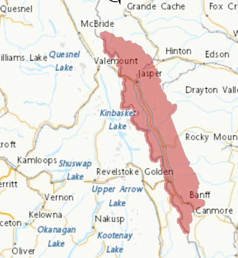
AB: Heavy snow (20 to 35 cm)will continue this morning along C
Icefields Parkway #93. Between 15 and 30 cm fell on Saturday, and another 5 cm is forecast today, tapering off this afternoon.
Icefields Parkway #93. Between 15 and 30 cm fell on Saturday, and another 5 cm is forecast today, tapering off this afternoon.

November 23, 2025 at 4:48 PM
AB: Heavy snow (20 to 35 cm)will continue this morning along C
Icefields Parkway #93. Between 15 and 30 cm fell on Saturday, and another 5 cm is forecast today, tapering off this afternoon.
Icefields Parkway #93. Between 15 and 30 cm fell on Saturday, and another 5 cm is forecast today, tapering off this afternoon.
BC: Heavy Rain (50-70 mm) along Yellowhead Highway #16 and North Coast Inland, between Prince Rupert and Kitimat with a frontal system moving sothward. Rain will begin near Kitimat early Thursday and become heavy in the afternoon and overnight, easing to showers late Friday morning.

November 20, 2025 at 1:19 AM
BC: Heavy Rain (50-70 mm) along Yellowhead Highway #16 and North Coast Inland, between Prince Rupert and Kitimat with a frontal system moving sothward. Rain will begin near Kitimat early Thursday and become heavy in the afternoon and overnight, easing to showers late Friday morning.
ON: Snow squalls (20 to 40 cm) off Lake Huron impacting Highway 401 between London and Woodstock tonight through Monday morning.
November 17, 2025 at 12:24 AM
ON: Snow squalls (20 to 40 cm) off Lake Huron impacting Highway 401 between London and Woodstock tonight through Monday morning.
ON: Snow squalls (25-30cm) expected along Highway 400 near Georgian Bay tonight through Monday morning. Lighter snow around Orillia and aroubd Oshawa (along #401)
November 17, 2025 at 12:19 AM
ON: Snow squalls (25-30cm) expected along Highway 400 near Georgian Bay tonight through Monday morning. Lighter snow around Orillia and aroubd Oshawa (along #401)
NL: Strong winds (80 km/h, and100 along the coast) across the southern Avalon Peninsula (along Trans-Canada #1 Clarenville to St John's) late this evening until late overnight tonight.


November 14, 2025 at 3:58 PM
NL: Strong winds (80 km/h, and100 along the coast) across the southern Avalon Peninsula (along Trans-Canada #1 Clarenville to St John's) late this evening until late overnight tonight.
NB: The first significant snowfall (10 to 20 cm) of the season is expected across Northwestern New Brunswick (Trans-Canada #2 from Edmunston to Fredericton) early Sunday morning to afternoon. On Sunday, allow extra time to reach your destination due to winter driving conditions.


November 14, 2025 at 3:47 PM
NB: The first significant snowfall (10 to 20 cm) of the season is expected across Northwestern New Brunswick (Trans-Canada #2 from Edmunston to Fredericton) early Sunday morning to afternoon. On Sunday, allow extra time to reach your destination due to winter driving conditions.
BC: Snowfall along Crowsnest Highway 3 (Near Kootenay Pass) with total amounts of 15 to 20 cm is expected from Friday morning till Saturday morning.
November 14, 2025 at 4:00 AM
BC: Snowfall along Crowsnest Highway 3 (Near Kootenay Pass) with total amounts of 15 to 20 cm is expected from Friday morning till Saturday morning.
ON/QU: Freezing rain (up to 10 mm of ice) in Ottawa Valley between Mattawa and Montreal this weekend from Saturday evening into Sunday morning. ALSO affecting: Laurentians and Lower Richelieu

November 13, 2025 at 11:38 PM
ON/QU: Freezing rain (up to 10 mm of ice) in Ottawa Valley between Mattawa and Montreal this weekend from Saturday evening into Sunday morning. ALSO affecting: Laurentians and Lower Richelieu
AB: Heavy snow (15 to 30 cm at higher elevations) along Highway 93 beginning this afternoon and continue through the night . Lower elevations (Banff and Jasper) should see little snow accumulation.
November 13, 2025 at 6:08 PM
AB: Heavy snow (15 to 30 cm at higher elevations) along Highway 93 beginning this afternoon and continue through the night . Lower elevations (Banff and Jasper) should see little snow accumulation.
BC: Trans-Canada #1 TO BE closed for 1 HOUR on Tue Nov 18 from 5 am until 6 am, about 7 to 11 km east of Sicamous for utility work.

November 13, 2025 at 5:21 PM
BC: Trans-Canada #1 TO BE closed for 1 HOUR on Tue Nov 18 from 5 am until 6 am, about 7 to 11 km east of Sicamous for utility work.
BC: Rain, at times heavy (40 to 60 mm) expected in Metro Vancouver, North Shore and east to Coquitlam and Maple Ridge) later this morning, continuing into Thursday.


November 12, 2025 at 1:47 PM
BC: Rain, at times heavy (40 to 60 mm) expected in Metro Vancouver, North Shore and east to Coquitlam and Maple Ridge) later this morning, continuing into Thursday.
NL: A prolonged period of significant rainfall (80 to 130 mm) is expected. along the south coast of Newfoundland from Channel-Port aux Basques to the Burin Peninsula until Wednesday morning.


November 11, 2025 at 6:16 PM
NL: A prolonged period of significant rainfall (80 to 130 mm) is expected. along the south coast of Newfoundland from Channel-Port aux Basques to the Burin Peninsula until Wednesday morning.
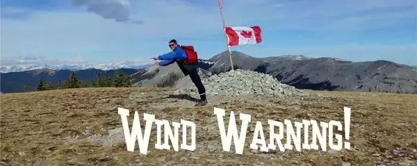
AB: Westerly wind gusts of 100 km/h to 115 km/h along Highway 2 from Calgary south to US border and along Crowsnest Highway #3 expected this morning and weakening this afternoon. High-sided vehicles will be pushed around by the wind.

November 10, 2025 at 2:45 PM
AB: Westerly wind gusts of 100 km/h to 115 km/h along Highway 2 from Calgary south to US border and along Crowsnest Highway #3 expected this morning and weakening this afternoon. High-sided vehicles will be pushed around by the wind.
This next week, we are going to draw attention to the cities along the Trans-Canada Highway system, and then finish with other cities we have great content for that are off the highway (mostly in southern Ontario). This hi-res map is on our site at transcanadahighway.com/traveltips/t...

November 9, 2025 at 6:40 PM
This next week, we are going to draw attention to the cities along the Trans-Canada Highway system, and then finish with other cities we have great content for that are off the highway (mostly in southern Ontario). This hi-res map is on our site at transcanadahighway.com/traveltips/t...