


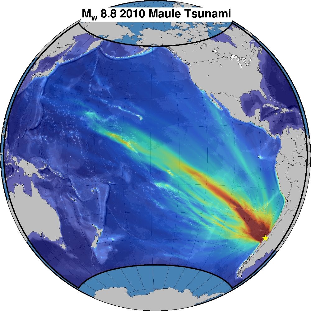
Bot de Sismos en Chile
@tatemblando.bsky.social
Hola, soy un #Bot made in 🇨🇱, por @555STi.cl, que publica información de los últimos #sismos ocurridos en #Chile.
La información es extraída desde el sitio de #sismología de la U. De Chile. ESTE BOT NO PREDICE NI ALERTA SISMOS ANTES QUE OCURRAN.
La información es extraída desde el sitio de #sismología de la U. De Chile. ESTE BOT NO PREDICE NI ALERTA SISMOS ANTES QUE OCURRAN.
⚠️ Nuevo #sismo Registrado ⚠️
Fecha: 24-12-2025
Hora: 04:54:41
Ubicación: 35 km al NE de Las Cabras
Profundidad: 41 km
Magnitud: 3.7
Latitud: -34.01
Longitud: -71.13
Ver Mapa
#terremoto #sismologia #chile #earthquake #alerta
Fecha: 24-12-2025
Hora: 04:54:41
Ubicación: 35 km al NE de Las Cabras
Profundidad: 41 km
Magnitud: 3.7
Latitud: -34.01
Longitud: -71.13
Ver Mapa
#terremoto #sismologia #chile #earthquake #alerta
December 24, 2025 at 7:59 AM
⚠️ Nuevo #sismo Registrado ⚠️
Fecha: 24-12-2025
Hora: 04:54:41
Ubicación: 35 km al NE de Las Cabras
Profundidad: 41 km
Magnitud: 3.7
Latitud: -34.01
Longitud: -71.13
Ver Mapa
#terremoto #sismologia #chile #earthquake #alerta
Fecha: 24-12-2025
Hora: 04:54:41
Ubicación: 35 km al NE de Las Cabras
Profundidad: 41 km
Magnitud: 3.7
Latitud: -34.01
Longitud: -71.13
Ver Mapa
#terremoto #sismologia #chile #earthquake #alerta
⚠️ Nuevo #sismo Registrado ⚠️
Fecha: 24-12-2025
Hora: 03:04:54
Ubicación: 25 km al N de Calama
Profundidad: 108 km
Magnitud: 2.8
Latitud: -22.25
Longitud: -68.91
Ver Mapa
#terremoto #sismologia #chile #earthquake #alerta
Fecha: 24-12-2025
Hora: 03:04:54
Ubicación: 25 km al N de Calama
Profundidad: 108 km
Magnitud: 2.8
Latitud: -22.25
Longitud: -68.91
Ver Mapa
#terremoto #sismologia #chile #earthquake #alerta
December 24, 2025 at 6:25 AM
⚠️ Nuevo #sismo Registrado ⚠️
Fecha: 24-12-2025
Hora: 03:04:54
Ubicación: 25 km al N de Calama
Profundidad: 108 km
Magnitud: 2.8
Latitud: -22.25
Longitud: -68.91
Ver Mapa
#terremoto #sismologia #chile #earthquake #alerta
Fecha: 24-12-2025
Hora: 03:04:54
Ubicación: 25 km al N de Calama
Profundidad: 108 km
Magnitud: 2.8
Latitud: -22.25
Longitud: -68.91
Ver Mapa
#terremoto #sismologia #chile #earthquake #alerta
⚠️ Nuevo #sismo Registrado ⚠️
Fecha: 24-12-2025
Hora: 03:10:12
Ubicación: 32 km al SO de Calama
Profundidad: 95 km
Magnitud: 4.3
Latitud: -22.63
Longitud: -69.18
Ver Mapa
#terremoto #sismologia #chile #earthquake #alerta
Fecha: 24-12-2025
Hora: 03:10:12
Ubicación: 32 km al SO de Calama
Profundidad: 95 km
Magnitud: 4.3
Latitud: -22.63
Longitud: -69.18
Ver Mapa
#terremoto #sismologia #chile #earthquake #alerta
December 24, 2025 at 6:15 AM
⚠️ Nuevo #sismo Registrado ⚠️
Fecha: 24-12-2025
Hora: 03:10:12
Ubicación: 32 km al SO de Calama
Profundidad: 95 km
Magnitud: 4.3
Latitud: -22.63
Longitud: -69.18
Ver Mapa
#terremoto #sismologia #chile #earthquake #alerta
Fecha: 24-12-2025
Hora: 03:10:12
Ubicación: 32 km al SO de Calama
Profundidad: 95 km
Magnitud: 4.3
Latitud: -22.63
Longitud: -69.18
Ver Mapa
#terremoto #sismologia #chile #earthquake #alerta
⚠️ Nuevo #sismo Registrado ⚠️
Fecha: 24-12-2025
Hora: 02:39:38
Ubicación: 33 km al SE de Curicó
Profundidad: 116 km
Magnitud: 2.5
Latitud: -35.22
Longitud: -71.02
Ver Mapa
#terremoto #sismologia #chile #earthquake #alerta
Fecha: 24-12-2025
Hora: 02:39:38
Ubicación: 33 km al SE de Curicó
Profundidad: 116 km
Magnitud: 2.5
Latitud: -35.22
Longitud: -71.02
Ver Mapa
#terremoto #sismologia #chile #earthquake #alerta
December 24, 2025 at 5:49 AM
⚠️ Nuevo #sismo Registrado ⚠️
Fecha: 24-12-2025
Hora: 02:39:38
Ubicación: 33 km al SE de Curicó
Profundidad: 116 km
Magnitud: 2.5
Latitud: -35.22
Longitud: -71.02
Ver Mapa
#terremoto #sismologia #chile #earthquake #alerta
Fecha: 24-12-2025
Hora: 02:39:38
Ubicación: 33 km al SE de Curicó
Profundidad: 116 km
Magnitud: 2.5
Latitud: -35.22
Longitud: -71.02
Ver Mapa
#terremoto #sismologia #chile #earthquake #alerta
⚠️ Nuevo #sismo Registrado ⚠️
Fecha: 24-12-2025
Hora: 02:28:42
Ubicación: 33 km al NO de Mina Collahuasi
Profundidad: 99 km
Magnitud: 2.6
Latitud: -20.59
Longitud: -68.86
Ver Mapa
#terremoto #sismologia #chile #earthquake #alerta
Fecha: 24-12-2025
Hora: 02:28:42
Ubicación: 33 km al NO de Mina Collahuasi
Profundidad: 99 km
Magnitud: 2.6
Latitud: -20.59
Longitud: -68.86
Ver Mapa
#terremoto #sismologia #chile #earthquake #alerta
December 24, 2025 at 5:44 AM
⚠️ Nuevo #sismo Registrado ⚠️
Fecha: 24-12-2025
Hora: 02:28:42
Ubicación: 33 km al NO de Mina Collahuasi
Profundidad: 99 km
Magnitud: 2.6
Latitud: -20.59
Longitud: -68.86
Ver Mapa
#terremoto #sismologia #chile #earthquake #alerta
Fecha: 24-12-2025
Hora: 02:28:42
Ubicación: 33 km al NO de Mina Collahuasi
Profundidad: 99 km
Magnitud: 2.6
Latitud: -20.59
Longitud: -68.86
Ver Mapa
#terremoto #sismologia #chile #earthquake #alerta
⚠️ Nuevo #sismo Registrado ⚠️
Fecha: 24-12-2025
Hora: 01:44:23
Ubicación: 51 km al SO de Ollagüe
Profundidad: 139 km
Magnitud: 2.6
Latitud: -21.62
Longitud: -68.50
Ver Mapa
#terremoto #sismologia #chile #earthquake #alerta
Fecha: 24-12-2025
Hora: 01:44:23
Ubicación: 51 km al SO de Ollagüe
Profundidad: 139 km
Magnitud: 2.6
Latitud: -21.62
Longitud: -68.50
Ver Mapa
#terremoto #sismologia #chile #earthquake #alerta
December 24, 2025 at 5:26 AM
⚠️ Nuevo #sismo Registrado ⚠️
Fecha: 24-12-2025
Hora: 01:44:23
Ubicación: 51 km al SO de Ollagüe
Profundidad: 139 km
Magnitud: 2.6
Latitud: -21.62
Longitud: -68.50
Ver Mapa
#terremoto #sismologia #chile #earthquake #alerta
Fecha: 24-12-2025
Hora: 01:44:23
Ubicación: 51 km al SO de Ollagüe
Profundidad: 139 km
Magnitud: 2.6
Latitud: -21.62
Longitud: -68.50
Ver Mapa
#terremoto #sismologia #chile #earthquake #alerta
⚠️ Nuevo #sismo Registrado ⚠️
Fecha: 24-12-2025
Hora: 00:16:14
Ubicación: 76 km al E de El Salvador
Profundidad: 147 km
Magnitud: 3.2
Latitud: -26.04
Longitud: -68.90
Ver Mapa
#terremoto #sismologia #chile #earthquake #alerta
Fecha: 24-12-2025
Hora: 00:16:14
Ubicación: 76 km al E de El Salvador
Profundidad: 147 km
Magnitud: 3.2
Latitud: -26.04
Longitud: -68.90
Ver Mapa
#terremoto #sismologia #chile #earthquake #alerta
December 24, 2025 at 3:30 AM
⚠️ Nuevo #sismo Registrado ⚠️
Fecha: 24-12-2025
Hora: 00:16:14
Ubicación: 76 km al E de El Salvador
Profundidad: 147 km
Magnitud: 3.2
Latitud: -26.04
Longitud: -68.90
Ver Mapa
#terremoto #sismologia #chile #earthquake #alerta
Fecha: 24-12-2025
Hora: 00:16:14
Ubicación: 76 km al E de El Salvador
Profundidad: 147 km
Magnitud: 3.2
Latitud: -26.04
Longitud: -68.90
Ver Mapa
#terremoto #sismologia #chile #earthquake #alerta
⚠️ Nuevo #sismo Registrado ⚠️
Fecha: 23-12-2025
Hora: 22:05:20
Ubicación: 24 km al O de La Ligua
Profundidad: 28 km
Magnitud: 4.7
Latitud: -32.36
Longitud: -71.46
Ver Mapa
#terremoto #sismologia #chile #earthquake #alerta
Fecha: 23-12-2025
Hora: 22:05:20
Ubicación: 24 km al O de La Ligua
Profundidad: 28 km
Magnitud: 4.7
Latitud: -32.36
Longitud: -71.46
Ver Mapa
#terremoto #sismologia #chile #earthquake #alerta
December 24, 2025 at 1:10 AM
⚠️ Nuevo #sismo Registrado ⚠️
Fecha: 23-12-2025
Hora: 22:05:20
Ubicación: 24 km al O de La Ligua
Profundidad: 28 km
Magnitud: 4.7
Latitud: -32.36
Longitud: -71.46
Ver Mapa
#terremoto #sismologia #chile #earthquake #alerta
Fecha: 23-12-2025
Hora: 22:05:20
Ubicación: 24 km al O de La Ligua
Profundidad: 28 km
Magnitud: 4.7
Latitud: -32.36
Longitud: -71.46
Ver Mapa
#terremoto #sismologia #chile #earthquake #alerta
⚠️ Nuevo #sismo Registrado ⚠️
Fecha: 23-12-2025
Hora: 20:35:04
Ubicación: 77 km al E de Socaire
Profundidad: 257 km
Magnitud: 3.4
Latitud: -23.43
Longitud: -67.15
Ver Mapa
#terremoto #sismologia #chile #earthquake #alerta
Fecha: 23-12-2025
Hora: 20:35:04
Ubicación: 77 km al E de Socaire
Profundidad: 257 km
Magnitud: 3.4
Latitud: -23.43
Longitud: -67.15
Ver Mapa
#terremoto #sismologia #chile #earthquake #alerta
December 23, 2025 at 11:56 PM
⚠️ Nuevo #sismo Registrado ⚠️
Fecha: 23-12-2025
Hora: 20:35:04
Ubicación: 77 km al E de Socaire
Profundidad: 257 km
Magnitud: 3.4
Latitud: -23.43
Longitud: -67.15
Ver Mapa
#terremoto #sismologia #chile #earthquake #alerta
Fecha: 23-12-2025
Hora: 20:35:04
Ubicación: 77 km al E de Socaire
Profundidad: 257 km
Magnitud: 3.4
Latitud: -23.43
Longitud: -67.15
Ver Mapa
#terremoto #sismologia #chile #earthquake #alerta
⚠️ Nuevo #sismo Registrado ⚠️
Fecha: 23-12-2025
Hora: 18:49:16
Ubicación: 37 km al N de Punta de Choros
Profundidad: 37 km
Magnitud: 3.4
Latitud: -28.92
Longitud: -71.47
Ver Mapa
#terremoto #sismologia #chile #earthquake #alerta
Fecha: 23-12-2025
Hora: 18:49:16
Ubicación: 37 km al N de Punta de Choros
Profundidad: 37 km
Magnitud: 3.4
Latitud: -28.92
Longitud: -71.47
Ver Mapa
#terremoto #sismologia #chile #earthquake #alerta
December 23, 2025 at 10:04 PM
⚠️ Nuevo #sismo Registrado ⚠️
Fecha: 23-12-2025
Hora: 18:49:16
Ubicación: 37 km al N de Punta de Choros
Profundidad: 37 km
Magnitud: 3.4
Latitud: -28.92
Longitud: -71.47
Ver Mapa
#terremoto #sismologia #chile #earthquake #alerta
Fecha: 23-12-2025
Hora: 18:49:16
Ubicación: 37 km al N de Punta de Choros
Profundidad: 37 km
Magnitud: 3.4
Latitud: -28.92
Longitud: -71.47
Ver Mapa
#terremoto #sismologia #chile #earthquake #alerta
⚠️ Nuevo #sismo Registrado ⚠️
Fecha: 23-12-2025
Hora: 15:40:39
Ubicación: 9 km al E de Parque Fray Jorge
Profundidad: 32 km
Magnitud: 3.3
Latitud: -30.67
Longitud: -71.59
Ver Mapa
#terremoto #sismologia #chile #earthquake #alerta
Fecha: 23-12-2025
Hora: 15:40:39
Ubicación: 9 km al E de Parque Fray Jorge
Profundidad: 32 km
Magnitud: 3.3
Latitud: -30.67
Longitud: -71.59
Ver Mapa
#terremoto #sismologia #chile #earthquake #alerta
December 23, 2025 at 6:53 PM
⚠️ Nuevo #sismo Registrado ⚠️
Fecha: 23-12-2025
Hora: 15:40:39
Ubicación: 9 km al E de Parque Fray Jorge
Profundidad: 32 km
Magnitud: 3.3
Latitud: -30.67
Longitud: -71.59
Ver Mapa
#terremoto #sismologia #chile #earthquake #alerta
Fecha: 23-12-2025
Hora: 15:40:39
Ubicación: 9 km al E de Parque Fray Jorge
Profundidad: 32 km
Magnitud: 3.3
Latitud: -30.67
Longitud: -71.59
Ver Mapa
#terremoto #sismologia #chile #earthquake #alerta
⚠️ Nuevo #sismo Registrado ⚠️
Fecha: 23-12-2025
Hora: 15:34:10
Ubicación: 41 km al S de Mina Collahuasi
Profundidad: 127 km
Magnitud: 2.6
Latitud: -21.19
Longitud: -68.73
Ver Mapa
#terremoto #sismologia #chile #earthquake #alerta
Fecha: 23-12-2025
Hora: 15:34:10
Ubicación: 41 km al S de Mina Collahuasi
Profundidad: 127 km
Magnitud: 2.6
Latitud: -21.19
Longitud: -68.73
Ver Mapa
#terremoto #sismologia #chile #earthquake #alerta
December 23, 2025 at 6:46 PM
⚠️ Nuevo #sismo Registrado ⚠️
Fecha: 23-12-2025
Hora: 15:34:10
Ubicación: 41 km al S de Mina Collahuasi
Profundidad: 127 km
Magnitud: 2.6
Latitud: -21.19
Longitud: -68.73
Ver Mapa
#terremoto #sismologia #chile #earthquake #alerta
Fecha: 23-12-2025
Hora: 15:34:10
Ubicación: 41 km al S de Mina Collahuasi
Profundidad: 127 km
Magnitud: 2.6
Latitud: -21.19
Longitud: -68.73
Ver Mapa
#terremoto #sismologia #chile #earthquake #alerta
⚠️ Nuevo #sismo Registrado ⚠️
Fecha: 23-12-2025
Hora: 15:27:32
Ubicación: 52 km al SO de Mina Collahuasi
Profundidad: 117 km
Magnitud: 2.7
Latitud: -21.09
Longitud: -69.07
Ver Mapa
#terremoto #sismologia #chile #earthquake #alerta
Fecha: 23-12-2025
Hora: 15:27:32
Ubicación: 52 km al SO de Mina Collahuasi
Profundidad: 117 km
Magnitud: 2.7
Latitud: -21.09
Longitud: -69.07
Ver Mapa
#terremoto #sismologia #chile #earthquake #alerta
December 23, 2025 at 6:45 PM
⚠️ Nuevo #sismo Registrado ⚠️
Fecha: 23-12-2025
Hora: 15:27:32
Ubicación: 52 km al SO de Mina Collahuasi
Profundidad: 117 km
Magnitud: 2.7
Latitud: -21.09
Longitud: -69.07
Ver Mapa
#terremoto #sismologia #chile #earthquake #alerta
Fecha: 23-12-2025
Hora: 15:27:32
Ubicación: 52 km al SO de Mina Collahuasi
Profundidad: 117 km
Magnitud: 2.7
Latitud: -21.09
Longitud: -69.07
Ver Mapa
#terremoto #sismologia #chile #earthquake #alerta
⚠️ Nuevo #sismo Registrado ⚠️
Fecha: 23-12-2025
Hora: 14:52:35
Ubicación: 82 km al SE de Socaire
Profundidad: 212 km
Magnitud: 4.4
Latitud: -24.24
Longitud: -67.51
Ver Mapa
#terremoto #sismologia #chile #earthquake #alerta
Fecha: 23-12-2025
Hora: 14:52:35
Ubicación: 82 km al SE de Socaire
Profundidad: 212 km
Magnitud: 4.4
Latitud: -24.24
Longitud: -67.51
Ver Mapa
#terremoto #sismologia #chile #earthquake #alerta
December 23, 2025 at 5:59 PM
⚠️ Nuevo #sismo Registrado ⚠️
Fecha: 23-12-2025
Hora: 14:52:35
Ubicación: 82 km al SE de Socaire
Profundidad: 212 km
Magnitud: 4.4
Latitud: -24.24
Longitud: -67.51
Ver Mapa
#terremoto #sismologia #chile #earthquake #alerta
Fecha: 23-12-2025
Hora: 14:52:35
Ubicación: 82 km al SE de Socaire
Profundidad: 212 km
Magnitud: 4.4
Latitud: -24.24
Longitud: -67.51
Ver Mapa
#terremoto #sismologia #chile #earthquake #alerta
⚠️ Nuevo #sismo Registrado ⚠️
Fecha: 23-12-2025
Hora: 06:47:33
Ubicación: 26 km al E de Curicó
Profundidad: 104 km
Magnitud: 2.8
Latitud: -34.88
Longitud: -70.98
Ver Mapa
#terremoto #sismologia #chile #earthquake #alerta
Fecha: 23-12-2025
Hora: 06:47:33
Ubicación: 26 km al E de Curicó
Profundidad: 104 km
Magnitud: 2.8
Latitud: -34.88
Longitud: -70.98
Ver Mapa
#terremoto #sismologia #chile #earthquake #alerta
December 23, 2025 at 10:14 AM
⚠️ Nuevo #sismo Registrado ⚠️
Fecha: 23-12-2025
Hora: 06:47:33
Ubicación: 26 km al E de Curicó
Profundidad: 104 km
Magnitud: 2.8
Latitud: -34.88
Longitud: -70.98
Ver Mapa
#terremoto #sismologia #chile #earthquake #alerta
Fecha: 23-12-2025
Hora: 06:47:33
Ubicación: 26 km al E de Curicó
Profundidad: 104 km
Magnitud: 2.8
Latitud: -34.88
Longitud: -70.98
Ver Mapa
#terremoto #sismologia #chile #earthquake #alerta
⚠️ Nuevo #sismo Registrado ⚠️
Fecha: 23-12-2025
Hora: 06:22:09
Ubicación: 28 km al NE de Bahía Mansa
Profundidad: 34 km
Magnitud: 3.1
Latitud: -40.35
Longitud: -73.61
Ver Mapa
#terremoto #sismologia #chile #earthquake #alerta
Fecha: 23-12-2025
Hora: 06:22:09
Ubicación: 28 km al NE de Bahía Mansa
Profundidad: 34 km
Magnitud: 3.1
Latitud: -40.35
Longitud: -73.61
Ver Mapa
#terremoto #sismologia #chile #earthquake #alerta
December 23, 2025 at 9:32 AM
⚠️ Nuevo #sismo Registrado ⚠️
Fecha: 23-12-2025
Hora: 06:22:09
Ubicación: 28 km al NE de Bahía Mansa
Profundidad: 34 km
Magnitud: 3.1
Latitud: -40.35
Longitud: -73.61
Ver Mapa
#terremoto #sismologia #chile #earthquake #alerta
Fecha: 23-12-2025
Hora: 06:22:09
Ubicación: 28 km al NE de Bahía Mansa
Profundidad: 34 km
Magnitud: 3.1
Latitud: -40.35
Longitud: -73.61
Ver Mapa
#terremoto #sismologia #chile #earthquake #alerta
⚠️ Nuevo #sismo Registrado ⚠️
Fecha: 23-12-2025
Hora: 04:15:51
Ubicación: 23 km al SO de Chillán
Profundidad: 66 km
Magnitud: 3.3
Latitud: -36.79
Longitud: -72.22
Ver Mapa
#terremoto #sismologia #chile #earthquake #alerta
Fecha: 23-12-2025
Hora: 04:15:51
Ubicación: 23 km al SO de Chillán
Profundidad: 66 km
Magnitud: 3.3
Latitud: -36.79
Longitud: -72.22
Ver Mapa
#terremoto #sismologia #chile #earthquake #alerta
December 23, 2025 at 7:27 AM
⚠️ Nuevo #sismo Registrado ⚠️
Fecha: 23-12-2025
Hora: 04:15:51
Ubicación: 23 km al SO de Chillán
Profundidad: 66 km
Magnitud: 3.3
Latitud: -36.79
Longitud: -72.22
Ver Mapa
#terremoto #sismologia #chile #earthquake #alerta
Fecha: 23-12-2025
Hora: 04:15:51
Ubicación: 23 km al SO de Chillán
Profundidad: 66 km
Magnitud: 3.3
Latitud: -36.79
Longitud: -72.22
Ver Mapa
#terremoto #sismologia #chile #earthquake #alerta
⚠️ Nuevo #sismo Registrado ⚠️
Fecha: 23-12-2025
Hora: 03:08:26
Ubicación: 54 km al S de Socaire
Profundidad: 235 km
Magnitud: 2.8
Latitud: -24.05
Longitud: -67.71
Ver Mapa
#terremoto #sismologia #chile #earthquake #alerta
Fecha: 23-12-2025
Hora: 03:08:26
Ubicación: 54 km al S de Socaire
Profundidad: 235 km
Magnitud: 2.8
Latitud: -24.05
Longitud: -67.71
Ver Mapa
#terremoto #sismologia #chile #earthquake #alerta
December 23, 2025 at 6:40 AM
⚠️ Nuevo #sismo Registrado ⚠️
Fecha: 23-12-2025
Hora: 03:08:26
Ubicación: 54 km al S de Socaire
Profundidad: 235 km
Magnitud: 2.8
Latitud: -24.05
Longitud: -67.71
Ver Mapa
#terremoto #sismologia #chile #earthquake #alerta
Fecha: 23-12-2025
Hora: 03:08:26
Ubicación: 54 km al S de Socaire
Profundidad: 235 km
Magnitud: 2.8
Latitud: -24.05
Longitud: -67.71
Ver Mapa
#terremoto #sismologia #chile #earthquake #alerta
⚠️ Nuevo #sismo Registrado ⚠️
Fecha: 23-12-2025
Hora: 02:22:05
Ubicación: 52 km al SE de Patache
Profundidad: 60 km
Magnitud: 2.6
Latitud: -21.17
Longitud: -69.89
Ver Mapa
#terremoto #sismologia #chile #earthquake #alerta
Fecha: 23-12-2025
Hora: 02:22:05
Ubicación: 52 km al SE de Patache
Profundidad: 60 km
Magnitud: 2.6
Latitud: -21.17
Longitud: -69.89
Ver Mapa
#terremoto #sismologia #chile #earthquake #alerta
December 23, 2025 at 5:33 AM
⚠️ Nuevo #sismo Registrado ⚠️
Fecha: 23-12-2025
Hora: 02:22:05
Ubicación: 52 km al SE de Patache
Profundidad: 60 km
Magnitud: 2.6
Latitud: -21.17
Longitud: -69.89
Ver Mapa
#terremoto #sismologia #chile #earthquake #alerta
Fecha: 23-12-2025
Hora: 02:22:05
Ubicación: 52 km al SE de Patache
Profundidad: 60 km
Magnitud: 2.6
Latitud: -21.17
Longitud: -69.89
Ver Mapa
#terremoto #sismologia #chile #earthquake #alerta
⚠️ Nuevo #sismo Registrado ⚠️
Fecha: 23-12-2025
Hora: 01:43:10
Ubicación: 28 km al SE de Pica
Profundidad: 109 km
Magnitud: 2.9
Latitud: -20.72
Longitud: -69.23
Ver Mapa
#terremoto #sismologia #chile #earthquake #alerta
Fecha: 23-12-2025
Hora: 01:43:10
Ubicación: 28 km al SE de Pica
Profundidad: 109 km
Magnitud: 2.9
Latitud: -20.72
Longitud: -69.23
Ver Mapa
#terremoto #sismologia #chile #earthquake #alerta
December 23, 2025 at 5:00 AM
⚠️ Nuevo #sismo Registrado ⚠️
Fecha: 23-12-2025
Hora: 01:43:10
Ubicación: 28 km al SE de Pica
Profundidad: 109 km
Magnitud: 2.9
Latitud: -20.72
Longitud: -69.23
Ver Mapa
#terremoto #sismologia #chile #earthquake #alerta
Fecha: 23-12-2025
Hora: 01:43:10
Ubicación: 28 km al SE de Pica
Profundidad: 109 km
Magnitud: 2.9
Latitud: -20.72
Longitud: -69.23
Ver Mapa
#terremoto #sismologia #chile #earthquake #alerta
⚠️ Nuevo #sismo Registrado ⚠️
Fecha: 23-12-2025
Hora: 01:46:28
Ubicación: 42 km al N de Pozo Almonte
Profundidad: 32 km
Magnitud: 4.1
Latitud: -19.89
Longitud: -69.72
Ver Mapa
#terremoto #sismologia #chile #earthquake #alerta
Fecha: 23-12-2025
Hora: 01:46:28
Ubicación: 42 km al N de Pozo Almonte
Profundidad: 32 km
Magnitud: 4.1
Latitud: -19.89
Longitud: -69.72
Ver Mapa
#terremoto #sismologia #chile #earthquake #alerta
December 23, 2025 at 4:51 AM
⚠️ Nuevo #sismo Registrado ⚠️
Fecha: 23-12-2025
Hora: 01:46:28
Ubicación: 42 km al N de Pozo Almonte
Profundidad: 32 km
Magnitud: 4.1
Latitud: -19.89
Longitud: -69.72
Ver Mapa
#terremoto #sismologia #chile #earthquake #alerta
Fecha: 23-12-2025
Hora: 01:46:28
Ubicación: 42 km al N de Pozo Almonte
Profundidad: 32 km
Magnitud: 4.1
Latitud: -19.89
Longitud: -69.72
Ver Mapa
#terremoto #sismologia #chile #earthquake #alerta
⚠️ Nuevo #sismo Registrado ⚠️
Fecha: 23-12-2025
Hora: 00:31:18
Ubicación: 108 km al NO de Constitución
Profundidad: 10 km
Magnitud: 2.5
Latitud: -34.85
Longitud: -73.44
Ver Mapa
#terremoto #sismologia #chile #earthquake #alerta
Fecha: 23-12-2025
Hora: 00:31:18
Ubicación: 108 km al NO de Constitución
Profundidad: 10 km
Magnitud: 2.5
Latitud: -34.85
Longitud: -73.44
Ver Mapa
#terremoto #sismologia #chile #earthquake #alerta
December 23, 2025 at 4:16 AM
⚠️ Nuevo #sismo Registrado ⚠️
Fecha: 23-12-2025
Hora: 00:31:18
Ubicación: 108 km al NO de Constitución
Profundidad: 10 km
Magnitud: 2.5
Latitud: -34.85
Longitud: -73.44
Ver Mapa
#terremoto #sismologia #chile #earthquake #alerta
Fecha: 23-12-2025
Hora: 00:31:18
Ubicación: 108 km al NO de Constitución
Profundidad: 10 km
Magnitud: 2.5
Latitud: -34.85
Longitud: -73.44
Ver Mapa
#terremoto #sismologia #chile #earthquake #alerta
⚠️ Nuevo #sismo Registrado ⚠️
Fecha: 22-12-2025
Hora: 23:29:00
Ubicación: 82 km al SE de Socaire
Profundidad: 194 km
Magnitud: 2.8
Latitud: -24.16
Longitud: -67.37
Ver Mapa
#terremoto #sismologia #chile #earthquake #alerta
Fecha: 22-12-2025
Hora: 23:29:00
Ubicación: 82 km al SE de Socaire
Profundidad: 194 km
Magnitud: 2.8
Latitud: -24.16
Longitud: -67.37
Ver Mapa
#terremoto #sismologia #chile #earthquake #alerta
December 23, 2025 at 2:43 AM
⚠️ Nuevo #sismo Registrado ⚠️
Fecha: 22-12-2025
Hora: 23:29:00
Ubicación: 82 km al SE de Socaire
Profundidad: 194 km
Magnitud: 2.8
Latitud: -24.16
Longitud: -67.37
Ver Mapa
#terremoto #sismologia #chile #earthquake #alerta
Fecha: 22-12-2025
Hora: 23:29:00
Ubicación: 82 km al SE de Socaire
Profundidad: 194 km
Magnitud: 2.8
Latitud: -24.16
Longitud: -67.37
Ver Mapa
#terremoto #sismologia #chile #earthquake #alerta
⚠️ Nuevo #sismo Registrado ⚠️
Fecha: 22-12-2025
Hora: 23:10:27
Ubicación: 47 km al SO de Mina Collahuasi
Profundidad: 113 km
Magnitud: 3.2
Latitud: -21.07
Longitud: -69.03
Ver Mapa
#terremoto #sismologia #chile #earthquake #alerta
Fecha: 22-12-2025
Hora: 23:10:27
Ubicación: 47 km al SO de Mina Collahuasi
Profundidad: 113 km
Magnitud: 3.2
Latitud: -21.07
Longitud: -69.03
Ver Mapa
#terremoto #sismologia #chile #earthquake #alerta
December 23, 2025 at 2:22 AM
⚠️ Nuevo #sismo Registrado ⚠️
Fecha: 22-12-2025
Hora: 23:10:27
Ubicación: 47 km al SO de Mina Collahuasi
Profundidad: 113 km
Magnitud: 3.2
Latitud: -21.07
Longitud: -69.03
Ver Mapa
#terremoto #sismologia #chile #earthquake #alerta
Fecha: 22-12-2025
Hora: 23:10:27
Ubicación: 47 km al SO de Mina Collahuasi
Profundidad: 113 km
Magnitud: 3.2
Latitud: -21.07
Longitud: -69.03
Ver Mapa
#terremoto #sismologia #chile #earthquake #alerta
⚠️ Nuevo #sismo Registrado ⚠️
Fecha: 22-12-2025
Hora: 19:29:41
Ubicación: 17 km al E de Pica
Profundidad: 106 km
Magnitud: 2.6
Latitud: -20.45
Longitud: -69.17
Ver Mapa
#terremoto #sismologia #chile #earthquake #alerta
Fecha: 22-12-2025
Hora: 19:29:41
Ubicación: 17 km al E de Pica
Profundidad: 106 km
Magnitud: 2.6
Latitud: -20.45
Longitud: -69.17
Ver Mapa
#terremoto #sismologia #chile #earthquake #alerta
December 22, 2025 at 10:44 PM
⚠️ Nuevo #sismo Registrado ⚠️
Fecha: 22-12-2025
Hora: 19:29:41
Ubicación: 17 km al E de Pica
Profundidad: 106 km
Magnitud: 2.6
Latitud: -20.45
Longitud: -69.17
Ver Mapa
#terremoto #sismologia #chile #earthquake #alerta
Fecha: 22-12-2025
Hora: 19:29:41
Ubicación: 17 km al E de Pica
Profundidad: 106 km
Magnitud: 2.6
Latitud: -20.45
Longitud: -69.17
Ver Mapa
#terremoto #sismologia #chile #earthquake #alerta