


Earth Topo Relief Bot
@reliefbot.bsky.social
Daily topographical relief visualizations of earth.
For requests: Reply on latest post with latitude,longitude coordinates like "48.85, 2.35" (land only).
🌍 Source code: https://github.com/Bastou/bot-bluesky-reliefs
👨💻 Made by @bastiencornier.bsky.social
For requests: Reply on latest post with latitude,longitude coordinates like "48.85, 2.35" (land only).
🌍 Source code: https://github.com/Bastou/bot-bluesky-reliefs
👨💻 Made by @bastiencornier.bsky.social
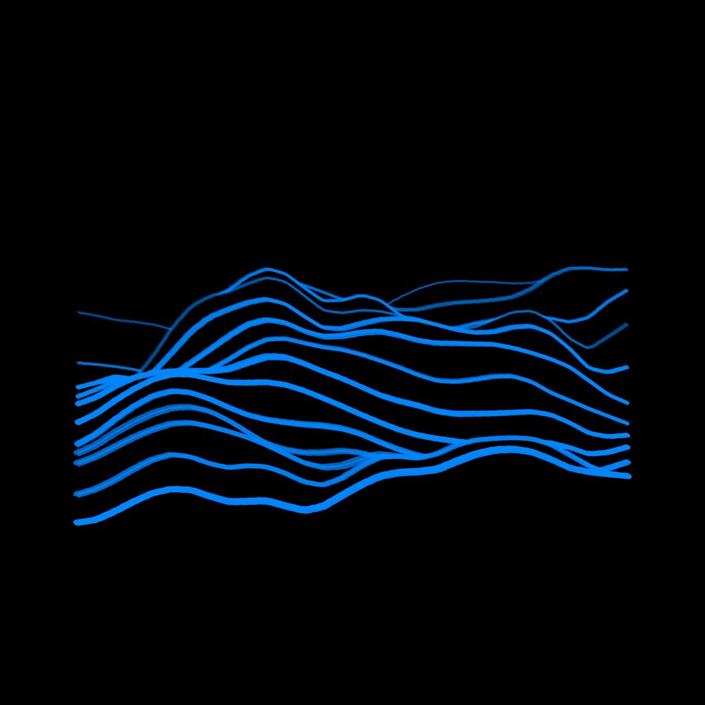
//\ Relief #198
Location: муниципальный округ Приуральский район, Ямало-Ненецкий автономный округ, Россия
Coordinates: 67.2677, 66.4959
Elevation Range: 396m to 945m
Terrain type: hilly
#ReliefOfTheDay #DataViz #Geography
Location: муниципальный округ Приуральский район, Ямало-Ненецкий автономный округ, Россия
Coordinates: 67.2677, 66.4959
Elevation Range: 396m to 945m
Terrain type: hilly
#ReliefOfTheDay #DataViz #Geography

December 5, 2025 at 11:12 AM
//\ Relief #198
Location: муниципальный округ Приуральский район, Ямало-Ненецкий автономный округ, Россия
Coordinates: 67.2677, 66.4959
Elevation Range: 396m to 945m
Terrain type: hilly
#ReliefOfTheDay #DataViz #Geography
Location: муниципальный округ Приуральский район, Ямало-Ненецкий автономный округ, Россия
Coordinates: 67.2677, 66.4959
Elevation Range: 396m to 945m
Terrain type: hilly
#ReliefOfTheDay #DataViz #Geography
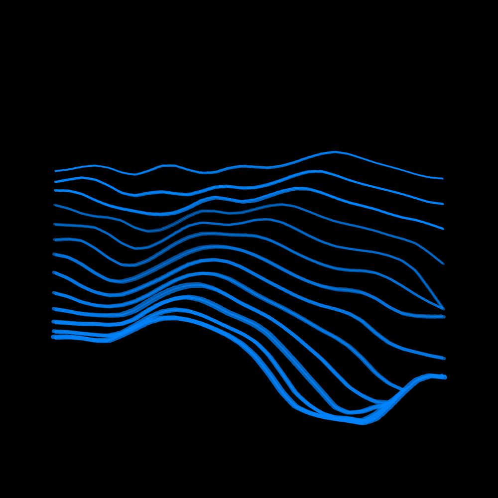
//\ Relief #197
Location: 牛腊冲新寨, 云南省, 中国
Coordinates: 23.5736, 103.9579
Elevation Range: 1370m to 1603m
Terrain type: high-hilly
#ReliefOfTheDay #DataViz #Geography
Location: 牛腊冲新寨, 云南省, 中国
Coordinates: 23.5736, 103.9579
Elevation Range: 1370m to 1603m
Terrain type: high-hilly
#ReliefOfTheDay #DataViz #Geography

December 4, 2025 at 11:13 AM
//\ Relief #197
Location: 牛腊冲新寨, 云南省, 中国
Coordinates: 23.5736, 103.9579
Elevation Range: 1370m to 1603m
Terrain type: high-hilly
#ReliefOfTheDay #DataViz #Geography
Location: 牛腊冲新寨, 云南省, 中国
Coordinates: 23.5736, 103.9579
Elevation Range: 1370m to 1603m
Terrain type: high-hilly
#ReliefOfTheDay #DataViz #Geography
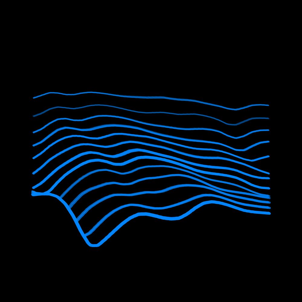
//\ Relief #196
Location: городское поселение Джебарики-Хая, Республика Саха (Якутия), Россия
Coordinates: 62.3167, 137.4544
Elevation Range: 348m to 1036m
Terrain type: hilly
#ReliefOfTheDay #DataViz #Geography
Location: городское поселение Джебарики-Хая, Республика Саха (Якутия), Россия
Coordinates: 62.3167, 137.4544
Elevation Range: 348m to 1036m
Terrain type: hilly
#ReliefOfTheDay #DataViz #Geography

December 3, 2025 at 11:12 AM
//\ Relief #196
Location: городское поселение Джебарики-Хая, Республика Саха (Якутия), Россия
Coordinates: 62.3167, 137.4544
Elevation Range: 348m to 1036m
Terrain type: hilly
#ReliefOfTheDay #DataViz #Geography
Location: городское поселение Джебарики-Хая, Республика Саха (Якутия), Россия
Coordinates: 62.3167, 137.4544
Elevation Range: 348m to 1036m
Terrain type: hilly
#ReliefOfTheDay #DataViz #Geography
//\ Relief #195
Location: Mbomou, Mbomou, Ködörösêse tî Bêafrîka / République centrafricaine
Coordinates: 5.3462, 22.1113
Elevation Range: 565m to 702m
Terrain type: rolling
#ReliefOfTheDay #DataViz #Geography
Location: Mbomou, Mbomou, Ködörösêse tî Bêafrîka / République centrafricaine
Coordinates: 5.3462, 22.1113
Elevation Range: 565m to 702m
Terrain type: rolling
#ReliefOfTheDay #DataViz #Geography

December 2, 2025 at 11:12 AM
//\ Relief #195
Location: Mbomou, Mbomou, Ködörösêse tî Bêafrîka / République centrafricaine
Coordinates: 5.3462, 22.1113
Elevation Range: 565m to 702m
Terrain type: rolling
#ReliefOfTheDay #DataViz #Geography
Location: Mbomou, Mbomou, Ködörösêse tî Bêafrîka / République centrafricaine
Coordinates: 5.3462, 22.1113
Elevation Range: 565m to 702m
Terrain type: rolling
#ReliefOfTheDay #DataViz #Geography
//\ Relief #194
Location: Tibesti تيبستي, Tibesti تيبستي, Tchad تشاد
Coordinates: 20.8885, 16.0975
Elevation Range: 713m to 1117m
Terrain type: hilly
#ReliefOfTheDay #DataViz #Geography
Location: Tibesti تيبستي, Tibesti تيبستي, Tchad تشاد
Coordinates: 20.8885, 16.0975
Elevation Range: 713m to 1117m
Terrain type: hilly
#ReliefOfTheDay #DataViz #Geography

December 1, 2025 at 11:11 AM
//\ Relief #194
Location: Tibesti تيبستي, Tibesti تيبستي, Tchad تشاد
Coordinates: 20.8885, 16.0975
Elevation Range: 713m to 1117m
Terrain type: hilly
#ReliefOfTheDay #DataViz #Geography
Location: Tibesti تيبستي, Tibesti تيبستي, Tchad تشاد
Coordinates: 20.8885, 16.0975
Elevation Range: 713m to 1117m
Terrain type: hilly
#ReliefOfTheDay #DataViz #Geography
//\ Relief #193
Location: Qeqertalik, Kalaallit Nunaat
Coordinates: 69.8328, -53.9033
Elevation Range: 395m to 1161m
Terrain type: hilly
#ReliefOfTheDay #DataViz #Geography
Location: Qeqertalik, Kalaallit Nunaat
Coordinates: 69.8328, -53.9033
Elevation Range: 395m to 1161m
Terrain type: hilly
#ReliefOfTheDay #DataViz #Geography

November 30, 2025 at 11:09 AM
//\ Relief #193
Location: Qeqertalik, Kalaallit Nunaat
Coordinates: 69.8328, -53.9033
Elevation Range: 395m to 1161m
Terrain type: hilly
#ReliefOfTheDay #DataViz #Geography
Location: Qeqertalik, Kalaallit Nunaat
Coordinates: 69.8328, -53.9033
Elevation Range: 395m to 1161m
Terrain type: hilly
#ReliefOfTheDay #DataViz #Geography
//\ Relief #192
Location: Cuatro Ciénegas, Coahuila, México
Coordinates: 26.4561, -101.8349
Elevation Range: 1093m to 2168m
Terrain type: high-mountainous
#ReliefOfTheDay #DataViz #Geography
Location: Cuatro Ciénegas, Coahuila, México
Coordinates: 26.4561, -101.8349
Elevation Range: 1093m to 2168m
Terrain type: high-mountainous
#ReliefOfTheDay #DataViz #Geography

November 29, 2025 at 11:09 AM
//\ Relief #192
Location: Cuatro Ciénegas, Coahuila, México
Coordinates: 26.4561, -101.8349
Elevation Range: 1093m to 2168m
Terrain type: high-mountainous
#ReliefOfTheDay #DataViz #Geography
Location: Cuatro Ciénegas, Coahuila, México
Coordinates: 26.4561, -101.8349
Elevation Range: 1093m to 2168m
Terrain type: high-mountainous
#ReliefOfTheDay #DataViz #Geography
//\ Relief #191
Location: Tamorot تمروت, Cercle de Bab Berred, Maroc ⵍⵎⵖⵔⵉⴱ المغرب
Coordinates: 34.9362, -4.8006
Elevation Range: 591m to 1209m
Terrain type: hilly
#ReliefOfTheDay #DataViz #Geography
Location: Tamorot تمروت, Cercle de Bab Berred, Maroc ⵍⵎⵖⵔⵉⴱ المغرب
Coordinates: 34.9362, -4.8006
Elevation Range: 591m to 1209m
Terrain type: hilly
#ReliefOfTheDay #DataViz #Geography

November 28, 2025 at 11:11 AM
//\ Relief #191
Location: Tamorot تمروت, Cercle de Bab Berred, Maroc ⵍⵎⵖⵔⵉⴱ المغرب
Coordinates: 34.9362, -4.8006
Elevation Range: 591m to 1209m
Terrain type: hilly
#ReliefOfTheDay #DataViz #Geography
Location: Tamorot تمروت, Cercle de Bab Berred, Maroc ⵍⵎⵖⵔⵉⴱ المغرب
Coordinates: 34.9362, -4.8006
Elevation Range: 591m to 1209m
Terrain type: hilly
#ReliefOfTheDay #DataViz #Geography
//\ Relief #190
Location: Route 202, Québec, Canada
Coordinates: 45.0406, -73.8785
Elevation Range: 65m to 291m
Terrain type: low-hilly
#ReliefOfTheDay #DataViz #Geography
Location: Route 202, Québec, Canada
Coordinates: 45.0406, -73.8785
Elevation Range: 65m to 291m
Terrain type: low-hilly
#ReliefOfTheDay #DataViz #Geography

November 27, 2025 at 11:11 AM
//\ Relief #190
Location: Route 202, Québec, Canada
Coordinates: 45.0406, -73.8785
Elevation Range: 65m to 291m
Terrain type: low-hilly
#ReliefOfTheDay #DataViz #Geography
Location: Route 202, Québec, Canada
Coordinates: 45.0406, -73.8785
Elevation Range: 65m to 291m
Terrain type: low-hilly
#ReliefOfTheDay #DataViz #Geography
//\ Relief #189
Location: Arharhar, Illizi, Algérie ⵍⵣⵣⴰⵢⴻⵔ الجزائر
Coordinates: 25.5385, 7.9745
Elevation Range: 1046m to 1419m
Terrain type: high-hilly
#ReliefOfTheDay #DataViz #Geography
Location: Arharhar, Illizi, Algérie ⵍⵣⵣⴰⵢⴻⵔ الجزائر
Coordinates: 25.5385, 7.9745
Elevation Range: 1046m to 1419m
Terrain type: high-hilly
#ReliefOfTheDay #DataViz #Geography

November 26, 2025 at 11:11 AM
//\ Relief #189
Location: Arharhar, Illizi, Algérie ⵍⵣⵣⴰⵢⴻⵔ الجزائر
Coordinates: 25.5385, 7.9745
Elevation Range: 1046m to 1419m
Terrain type: high-hilly
#ReliefOfTheDay #DataViz #Geography
Location: Arharhar, Illizi, Algérie ⵍⵣⵣⴰⵢⴻⵔ الجزائر
Coordinates: 25.5385, 7.9745
Elevation Range: 1046m to 1419m
Terrain type: high-hilly
#ReliefOfTheDay #DataViz #Geography
//\ Relief #188
Location: دهستان منتظریه, استان خراسان جنوبی, ایران
Coordinates: 33.5300, 56.2609
Elevation Range: 1231m to 1610m
Terrain type: high-hilly
#ReliefOfTheDay #DataViz #Geography
Location: دهستان منتظریه, استان خراسان جنوبی, ایران
Coordinates: 33.5300, 56.2609
Elevation Range: 1231m to 1610m
Terrain type: high-hilly
#ReliefOfTheDay #DataViz #Geography

November 25, 2025 at 11:11 AM
//\ Relief #188
Location: دهستان منتظریه, استان خراسان جنوبی, ایران
Coordinates: 33.5300, 56.2609
Elevation Range: 1231m to 1610m
Terrain type: high-hilly
#ReliefOfTheDay #DataViz #Geography
Location: دهستان منتظریه, استان خراسان جنوبی, ایران
Coordinates: 33.5300, 56.2609
Elevation Range: 1231m to 1610m
Terrain type: high-hilly
#ReliefOfTheDay #DataViz #Geography
//\ Relief #187
Location: 屏边县, 云南省, 中国
Coordinates: 23.0695, 103.8182
Elevation Range: 1078m to 2218m
Terrain type: high-mountainous
#ReliefOfTheDay #DataViz #Geography
Location: 屏边县, 云南省, 中国
Coordinates: 23.0695, 103.8182
Elevation Range: 1078m to 2218m
Terrain type: high-mountainous
#ReliefOfTheDay #DataViz #Geography

November 24, 2025 at 11:11 AM
//\ Relief #187
Location: 屏边县, 云南省, 中国
Coordinates: 23.0695, 103.8182
Elevation Range: 1078m to 2218m
Terrain type: high-mountainous
#ReliefOfTheDay #DataViz #Geography
Location: 屏边县, 云南省, 中国
Coordinates: 23.0695, 103.8182
Elevation Range: 1078m to 2218m
Terrain type: high-mountainous
#ReliefOfTheDay #DataViz #Geography
//\ Relief #186
Location: Les Ararys, Provence-Alpes-Côte d'Azur, France
Coordinates: 44.5176, 5.8526
Elevation Range: 802m to 1563m
Terrain type: high-hilly
#ReliefOfTheDay #DataViz #Geography
Location: Les Ararys, Provence-Alpes-Côte d'Azur, France
Coordinates: 44.5176, 5.8526
Elevation Range: 802m to 1563m
Terrain type: high-hilly
#ReliefOfTheDay #DataViz #Geography
November 23, 2025 at 11:09 AM
//\ Relief #186
Location: Les Ararys, Provence-Alpes-Côte d'Azur, France
Coordinates: 44.5176, 5.8526
Elevation Range: 802m to 1563m
Terrain type: high-hilly
#ReliefOfTheDay #DataViz #Geography
Location: Les Ararys, Provence-Alpes-Côte d'Azur, France
Coordinates: 44.5176, 5.8526
Elevation Range: 802m to 1563m
Terrain type: high-hilly
#ReliefOfTheDay #DataViz #Geography
//\ Relief #185
Location: 2440, West Virginia, United States of America
Coordinates: 39.1397, -78.5764
Elevation Range: 275m to 623m
Terrain type: hilly
#ReliefOfTheDay #DataViz #Geography
Location: 2440, West Virginia, United States of America
Coordinates: 39.1397, -78.5764
Elevation Range: 275m to 623m
Terrain type: hilly
#ReliefOfTheDay #DataViz #Geography
November 22, 2025 at 11:08 AM
//\ Relief #185
Location: 2440, West Virginia, United States of America
Coordinates: 39.1397, -78.5764
Elevation Range: 275m to 623m
Terrain type: hilly
#ReliefOfTheDay #DataViz #Geography
Location: 2440, West Virginia, United States of America
Coordinates: 39.1397, -78.5764
Elevation Range: 275m to 623m
Terrain type: hilly
#ReliefOfTheDay #DataViz #Geography
//\ Relief #184
Location: Tibagi, Paraná, Brasil
Coordinates: -24.6314, -50.1959
Elevation Range: 889m to 1238m
Terrain type: high-hilly
#ReliefOfTheDay #DataViz #Geography
Location: Tibagi, Paraná, Brasil
Coordinates: -24.6314, -50.1959
Elevation Range: 889m to 1238m
Terrain type: high-hilly
#ReliefOfTheDay #DataViz #Geography

November 21, 2025 at 11:10 AM
//\ Relief #184
Location: Tibagi, Paraná, Brasil
Coordinates: -24.6314, -50.1959
Elevation Range: 889m to 1238m
Terrain type: high-hilly
#ReliefOfTheDay #DataViz #Geography
Location: Tibagi, Paraná, Brasil
Coordinates: -24.6314, -50.1959
Elevation Range: 889m to 1238m
Terrain type: high-hilly
#ReliefOfTheDay #DataViz #Geography
//\ Relief #183
Location: Енисейский район, Красноярский край, Россия
Coordinates: 60.3454, 91.0911
Elevation Range: 350m to 673m
Terrain type: hilly
#ReliefOfTheDay #DataViz #Geography
Location: Енисейский район, Красноярский край, Россия
Coordinates: 60.3454, 91.0911
Elevation Range: 350m to 673m
Terrain type: hilly
#ReliefOfTheDay #DataViz #Geography

November 20, 2025 at 11:11 AM
//\ Relief #183
Location: Енисейский район, Красноярский край, Россия
Coordinates: 60.3454, 91.0911
Elevation Range: 350m to 673m
Terrain type: hilly
#ReliefOfTheDay #DataViz #Geography
Location: Енисейский район, Красноярский край, Россия
Coordinates: 60.3454, 91.0911
Elevation Range: 350m to 673m
Terrain type: hilly
#ReliefOfTheDay #DataViz #Geography
//\ Relief #182
Location: قربان کندی, شهرستان هشترود, ایران
Coordinates: 37.5341, 46.5773
Elevation Range: 1957m to 2345m
Terrain type: high-hilly
#ReliefOfTheDay #DataViz #Geography
Location: قربان کندی, شهرستان هشترود, ایران
Coordinates: 37.5341, 46.5773
Elevation Range: 1957m to 2345m
Terrain type: high-hilly
#ReliefOfTheDay #DataViz #Geography
November 19, 2025 at 11:10 AM
//\ Relief #182
Location: قربان کندی, شهرستان هشترود, ایران
Coordinates: 37.5341, 46.5773
Elevation Range: 1957m to 2345m
Terrain type: high-hilly
#ReliefOfTheDay #DataViz #Geography
Location: قربان کندی, شهرستان هشترود, ایران
Coordinates: 37.5341, 46.5773
Elevation Range: 1957m to 2345m
Terrain type: high-hilly
#ReliefOfTheDay #DataViz #Geography
//\ Relief #181
Location: Могод ᠮᠣᠭᠤᠳᠤ, Булган ᠪᠤᠯᠠᠭᠠᠨ, Монгол улс ᠮᠤᠩᠭᠤᠯ ᠤᠯᠤᠰ
Coordinates: 48.3229, 103.0412
Elevation Range: 1392m to 1969m
Terrain type: high-hilly
#ReliefOfTheDay #DataViz #Geography
Location: Могод ᠮᠣᠭᠤᠳᠤ, Булган ᠪᠤᠯᠠᠭᠠᠨ, Монгол улс ᠮᠤᠩᠭᠤᠯ ᠤᠯᠤᠰ
Coordinates: 48.3229, 103.0412
Elevation Range: 1392m to 1969m
Terrain type: high-hilly
#ReliefOfTheDay #DataViz #Geography

November 18, 2025 at 11:11 AM
//\ Relief #181
Location: Могод ᠮᠣᠭᠤᠳᠤ, Булган ᠪᠤᠯᠠᠭᠠᠨ, Монгол улс ᠮᠤᠩᠭᠤᠯ ᠤᠯᠤᠰ
Coordinates: 48.3229, 103.0412
Elevation Range: 1392m to 1969m
Terrain type: high-hilly
#ReliefOfTheDay #DataViz #Geography
Location: Могод ᠮᠣᠭᠤᠳᠤ, Булган ᠪᠤᠯᠠᠭᠠᠨ, Монгол улс ᠮᠤᠩᠭᠤᠯ ᠤᠯᠤᠰ
Coordinates: 48.3229, 103.0412
Elevation Range: 1392m to 1969m
Terrain type: high-hilly
#ReliefOfTheDay #DataViz #Geography
//\ Relief #180
Location: 杨集镇, 湖北省, 中国
Coordinates: 31.1808, 112.9748
Elevation Range: 201m to 521m
Terrain type: hilly
#ReliefOfTheDay #DataViz #Geography
Location: 杨集镇, 湖北省, 中国
Coordinates: 31.1808, 112.9748
Elevation Range: 201m to 521m
Terrain type: hilly
#ReliefOfTheDay #DataViz #Geography

November 17, 2025 at 11:11 AM
//\ Relief #180
Location: 杨集镇, 湖北省, 中国
Coordinates: 31.1808, 112.9748
Elevation Range: 201m to 521m
Terrain type: hilly
#ReliefOfTheDay #DataViz #Geography
Location: 杨集镇, 湖北省, 中国
Coordinates: 31.1808, 112.9748
Elevation Range: 201m to 521m
Terrain type: hilly
#ReliefOfTheDay #DataViz #Geography
//\ Relief #179
Location: 环县, 甘肃省, 中国
Coordinates: 36.2383, 106.7402
Elevation Range: 1496m to 1799m
Terrain type: high-hilly
#ReliefOfTheDay #DataViz #Geography
Location: 环县, 甘肃省, 中国
Coordinates: 36.2383, 106.7402
Elevation Range: 1496m to 1799m
Terrain type: high-hilly
#ReliefOfTheDay #DataViz #Geography

November 16, 2025 at 11:09 AM
//\ Relief #179
Location: 环县, 甘肃省, 中国
Coordinates: 36.2383, 106.7402
Elevation Range: 1496m to 1799m
Terrain type: high-hilly
#ReliefOfTheDay #DataViz #Geography
Location: 环县, 甘肃省, 中国
Coordinates: 36.2383, 106.7402
Elevation Range: 1496m to 1799m
Terrain type: high-hilly
#ReliefOfTheDay #DataViz #Geography
//\ Relief #178
Location: Красноярск - Северо-Енисейск, Красноярский край, Россия
Coordinates: 58.7108, 92.9835
Elevation Range: 129m to 417m
Terrain type: hilly
#ReliefOfTheDay #DataViz #Geography
Location: Красноярск - Северо-Енисейск, Красноярский край, Россия
Coordinates: 58.7108, 92.9835
Elevation Range: 129m to 417m
Terrain type: hilly
#ReliefOfTheDay #DataViz #Geography

November 15, 2025 at 11:08 AM
//\ Relief #178
Location: Красноярск - Северо-Енисейск, Красноярский край, Россия
Coordinates: 58.7108, 92.9835
Elevation Range: 129m to 417m
Terrain type: hilly
#ReliefOfTheDay #DataViz #Geography
Location: Красноярск - Северо-Енисейск, Красноярский край, Россия
Coordinates: 58.7108, 92.9835
Elevation Range: 129m to 417m
Terrain type: hilly
#ReliefOfTheDay #DataViz #Geography
//\ Relief #177
Location: Tierralta, Córdoba, Colombia
Coordinates: 8.0513, -75.9416
Elevation Range: 103m to 709m
Terrain type: hilly
#ReliefOfTheDay #DataViz #Geography
Location: Tierralta, Córdoba, Colombia
Coordinates: 8.0513, -75.9416
Elevation Range: 103m to 709m
Terrain type: hilly
#ReliefOfTheDay #DataViz #Geography

November 14, 2025 at 11:10 AM
//\ Relief #177
Location: Tierralta, Córdoba, Colombia
Coordinates: 8.0513, -75.9416
Elevation Range: 103m to 709m
Terrain type: hilly
#ReliefOfTheDay #DataViz #Geography
Location: Tierralta, Córdoba, Colombia
Coordinates: 8.0513, -75.9416
Elevation Range: 103m to 709m
Terrain type: hilly
#ReliefOfTheDay #DataViz #Geography
//\ Relief #176
Location: ก้อ, Li, ประเทศไทย
Coordinates: 17.5530, 98.8727
Elevation Range: 533m to 736m
Terrain type: hilly
#ReliefOfTheDay #DataViz #Geography
Location: ก้อ, Li, ประเทศไทย
Coordinates: 17.5530, 98.8727
Elevation Range: 533m to 736m
Terrain type: hilly
#ReliefOfTheDay #DataViz #Geography

November 13, 2025 at 11:11 AM
//\ Relief #176
Location: ก้อ, Li, ประเทศไทย
Coordinates: 17.5530, 98.8727
Elevation Range: 533m to 736m
Terrain type: hilly
#ReliefOfTheDay #DataViz #Geography
Location: ก้อ, Li, ประเทศไทย
Coordinates: 17.5530, 98.8727
Elevation Range: 533m to 736m
Terrain type: hilly
#ReliefOfTheDay #DataViz #Geography
//\ Relief #175
Location: Эвенкийский район, Красноярский край, Россия
Coordinates: 64.3959, 98.7306
Elevation Range: 432m to 773m
Terrain type: hilly
#ReliefOfTheDay #DataViz #Geography
Location: Эвенкийский район, Красноярский край, Россия
Coordinates: 64.3959, 98.7306
Elevation Range: 432m to 773m
Terrain type: hilly
#ReliefOfTheDay #DataViz #Geography

November 12, 2025 at 11:10 AM
//\ Relief #175
Location: Эвенкийский район, Красноярский край, Россия
Coordinates: 64.3959, 98.7306
Elevation Range: 432m to 773m
Terrain type: hilly
#ReliefOfTheDay #DataViz #Geography
Location: Эвенкийский район, Красноярский край, Россия
Coordinates: 64.3959, 98.7306
Elevation Range: 432m to 773m
Terrain type: hilly
#ReliefOfTheDay #DataViz #Geography
//\ Relief #174
Location: Lajeado Grande, Santa Catarina, Brasil
Coordinates: -26.8201, -52.5400
Elevation Range: 392m to 675m
Terrain type: hilly
#ReliefOfTheDay #DataViz #Geography
Location: Lajeado Grande, Santa Catarina, Brasil
Coordinates: -26.8201, -52.5400
Elevation Range: 392m to 675m
Terrain type: hilly
#ReliefOfTheDay #DataViz #Geography

November 11, 2025 at 11:11 AM
//\ Relief #174
Location: Lajeado Grande, Santa Catarina, Brasil
Coordinates: -26.8201, -52.5400
Elevation Range: 392m to 675m
Terrain type: hilly
#ReliefOfTheDay #DataViz #Geography
Location: Lajeado Grande, Santa Catarina, Brasil
Coordinates: -26.8201, -52.5400
Elevation Range: 392m to 675m
Terrain type: hilly
#ReliefOfTheDay #DataViz #Geography