


Paul Huttner
@paulhuttnerweather.bsky.social
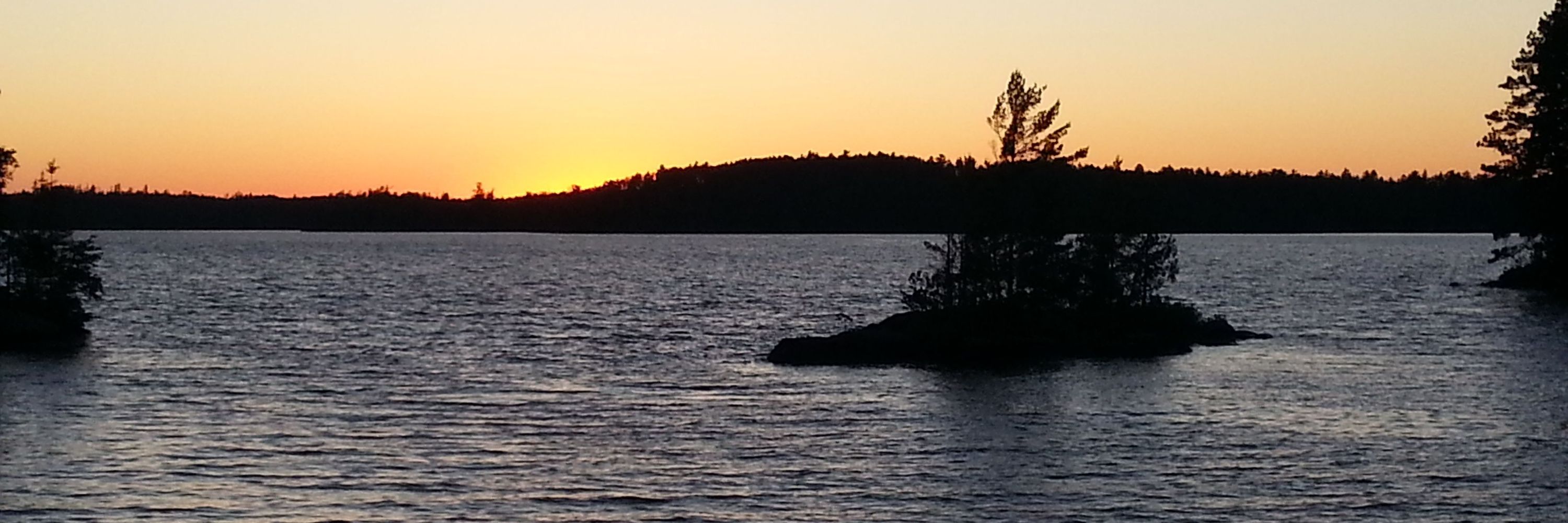
MPR News chief meteorologist. Weather, guitars, and sunsets make me happy.
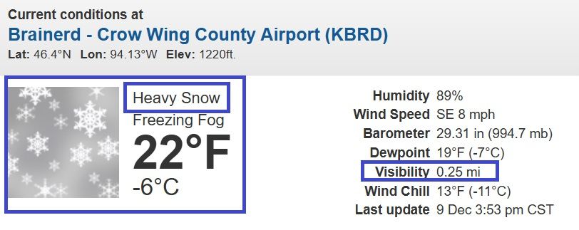
Absolutely dumping snow now across central MN.
1/4S+ (S+= heavy snow!) now at Brainerd to St. Cloud area. ❄️❄️❄️
Snowfall rates 1"-2" per hour now.
north of MSP.
Some of these heavier snow bands may work into MSP next 2-3 hours...
#mnwx
1/4S+ (S+= heavy snow!) now at Brainerd to St. Cloud area. ❄️❄️❄️
Snowfall rates 1"-2" per hour now.
north of MSP.
Some of these heavier snow bands may work into MSP next 2-3 hours...
#mnwx
December 9, 2025 at 10:06 PM
Absolutely dumping snow now across central MN.
1/4S+ (S+= heavy snow!) now at Brainerd to St. Cloud area. ❄️❄️❄️
Snowfall rates 1"-2" per hour now.
north of MSP.
Some of these heavier snow bands may work into MSP next 2-3 hours...
#mnwx
1/4S+ (S+= heavy snow!) now at Brainerd to St. Cloud area. ❄️❄️❄️
Snowfall rates 1"-2" per hour now.
north of MSP.
Some of these heavier snow bands may work into MSP next 2-3 hours...
#mnwx
It's here! ❄️
Latest 18Z HRRR model brings heavier snow of 4" to 6" into MSP core by tomorrow.
Heavy snowfall bursts are looking more likely in the Twin Cities through this evening.
Icy precip too.
Buckle up!
#mnwx
www.mprnews.org/story/2025/1...
Latest 18Z HRRR model brings heavier snow of 4" to 6" into MSP core by tomorrow.
Heavy snowfall bursts are looking more likely in the Twin Cities through this evening.
Icy precip too.
Buckle up!
#mnwx
www.mprnews.org/story/2025/1...

Storm update: Winter storm warnings include northeast Twin Cities
A powerful Clipper is delivering heavy snow and ice to much of Minnesota. High winds gusting over 50 mph will cause blowing snow through Wednesday morning especially in southwest Minnesota.
www.mprnews.org
December 9, 2025 at 7:37 PM
It's here! ❄️
Latest 18Z HRRR model brings heavier snow of 4" to 6" into MSP core by tomorrow.
Heavy snowfall bursts are looking more likely in the Twin Cities through this evening.
Icy precip too.
Buckle up!
#mnwx
www.mprnews.org/story/2025/1...
Latest 18Z HRRR model brings heavier snow of 4" to 6" into MSP core by tomorrow.
Heavy snowfall bursts are looking more likely in the Twin Cities through this evening.
Icy precip too.
Buckle up!
#mnwx
www.mprnews.org/story/2025/1...
Winter storm warnings include the northern Twin Cities.
If the storm shifts even 30 miles south, they will expand in the metro.
Fun times...
#mnwx
www.mprnews.org/story/2025/1...
If the storm shifts even 30 miles south, they will expand in the metro.
Fun times...
#mnwx
www.mprnews.org/story/2025/1...

Clipper parade: Winter storm warnings include northern Twin Cities
A potent Alberta Clipper brings heavy snow and winds to Minnesota Tuesday. Travel will be difficult especially late Tuesday and early Wednesday.
www.mprnews.org
December 8, 2025 at 11:17 PM
Winter storm warnings include the northern Twin Cities.
If the storm shifts even 30 miles south, they will expand in the metro.
Fun times...
#mnwx
www.mprnews.org/story/2025/1...
If the storm shifts even 30 miles south, they will expand in the metro.
Fun times...
#mnwx
www.mprnews.org/story/2025/1...
Happy Thanksgiving everyone! 🦃
Here's my latest thinking on the next snow event aiming for southern MN, Iowa, WI, and Chicago Fri night/Sat. ❄️
Twin Cities rides northern edge cutoff and could see less snow if dry air wins out.
Travel safely!
#mnwx
www.mprnews.org/story/2025/1...
Here's my latest thinking on the next snow event aiming for southern MN, Iowa, WI, and Chicago Fri night/Sat. ❄️
Twin Cities rides northern edge cutoff and could see less snow if dry air wins out.
Travel safely!
#mnwx
www.mprnews.org/story/2025/1...

Next snow event Friday night through Saturday from MSP southward
A long-duration fluffy snowfall event will drop snow Friday night through Saturday across southern Minnesota, Iowa, Wisconsin, and the Chicago area.
www.mprnews.org
November 27, 2025 at 8:36 PM
Happy Thanksgiving everyone! 🦃
Here's my latest thinking on the next snow event aiming for southern MN, Iowa, WI, and Chicago Fri night/Sat. ❄️
Twin Cities rides northern edge cutoff and could see less snow if dry air wins out.
Travel safely!
#mnwx
www.mprnews.org/story/2025/1...
Here's my latest thinking on the next snow event aiming for southern MN, Iowa, WI, and Chicago Fri night/Sat. ❄️
Twin Cities rides northern edge cutoff and could see less snow if dry air wins out.
Travel safely!
#mnwx
www.mprnews.org/story/2025/1...
Cue the (still too early) snowfall maps for Sat. ❄️
Next wintry storm drops heavy snow in Iowa, southern MN, WI, to Chicago Fri night & Saturday.
MSP rides north edge.
Still way early for credible snow forecasts.
Here's what we know/don't know yet.
#mnwx
www.mprnews.org/story/2025/1...
Next wintry storm drops heavy snow in Iowa, southern MN, WI, to Chicago Fri night & Saturday.
MSP rides north edge.
Still way early for credible snow forecasts.
Here's what we know/don't know yet.
#mnwx
www.mprnews.org/story/2025/1...

Winter storm watch: Heavy snow potential for southern Minnesota Friday into Saturday.
Thanksgiving travel looks dy. But the next storm system is aiming for southern Minnesota late Friday and Saturday.
www.mprnews.org
November 26, 2025 at 11:07 PM
Cue the (still too early) snowfall maps for Sat. ❄️
Next wintry storm drops heavy snow in Iowa, southern MN, WI, to Chicago Fri night & Saturday.
MSP rides north edge.
Still way early for credible snow forecasts.
Here's what we know/don't know yet.
#mnwx
www.mprnews.org/story/2025/1...
Next wintry storm drops heavy snow in Iowa, southern MN, WI, to Chicago Fri night & Saturday.
MSP rides north edge.
Still way early for credible snow forecasts.
Here's what we know/don't know yet.
#mnwx
www.mprnews.org/story/2025/1...
Welcome to instant winter. ❄️
Our first wintry storm of the season was ferocious.
High winds, tree damage, and sticky snow.
Sadly 1 storm fatality near Two Harbors.
MSP area snowfall ranges from 2" (south) to 5.7 " (north)
#mnwx
www.mprnews.org/story/2025/1...
Our first wintry storm of the season was ferocious.
High winds, tree damage, and sticky snow.
Sadly 1 storm fatality near Two Harbors.
MSP area snowfall ranges from 2" (south) to 5.7 " (north)
#mnwx
www.mprnews.org/story/2025/1...

Ferocious storm caused tree damage; hefty snowfall totals
A ferocious wintry storm in late November caused travel problems and tree damage around parts of Minnesota and Wisconsin.
www.mprnews.org
November 26, 2025 at 7:48 PM
Welcome to instant winter. ❄️
Our first wintry storm of the season was ferocious.
High winds, tree damage, and sticky snow.
Sadly 1 storm fatality near Two Harbors.
MSP area snowfall ranges from 2" (south) to 5.7 " (north)
#mnwx
www.mprnews.org/story/2025/1...
Our first wintry storm of the season was ferocious.
High winds, tree damage, and sticky snow.
Sadly 1 storm fatality near Two Harbors.
MSP area snowfall ranges from 2" (south) to 5.7 " (north)
#mnwx
www.mprnews.org/story/2025/1...
Rain quickly changing to snow now across MSP from west to east.
Snowfall totals so far
Baxter 7"
Rothsay 7"
Brainerd 6.5"
Pelican Rapids 6.3"
Duluth 4.5"
Latest storm update.
#mnwx
www.mprnews.org/story/2025/1...
Snowfall totals so far
Baxter 7"
Rothsay 7"
Brainerd 6.5"
Pelican Rapids 6.3"
Duluth 4.5"
Latest storm update.
#mnwx
www.mprnews.org/story/2025/1...

Storm update: Snowfall totals and high winds increasing into Wednesday morning.
A feisty wintry storm is dumping wind-blown snow across much of Minnesota overnight into Wednesday morning. Weather conditions will gradually improve later Wednesday.
www.mprnews.org
November 26, 2025 at 3:39 AM
Rain quickly changing to snow now across MSP from west to east.
Snowfall totals so far
Baxter 7"
Rothsay 7"
Brainerd 6.5"
Pelican Rapids 6.3"
Duluth 4.5"
Latest storm update.
#mnwx
www.mprnews.org/story/2025/1...
Snowfall totals so far
Baxter 7"
Rothsay 7"
Brainerd 6.5"
Pelican Rapids 6.3"
Duluth 4.5"
Latest storm update.
#mnwx
www.mprnews.org/story/2025/1...

November 26, 2025 at 1:27 AM
Storm update: Heavy snow (1"-2"/hour) already falling I-94 Fargo-Alexandria.
Rain (thunder?) to snow tonight MSP 6-10 p.m.
Wind-whipped snow overnight.
3" to 6" range likely MSP. (heaviest north)
5" to 10"+ central MN -North Shore.
Icy AM commute!
#mnwx
www.mprnews.org/story/2025/1...
Rain (thunder?) to snow tonight MSP 6-10 p.m.
Wind-whipped snow overnight.
3" to 6" range likely MSP. (heaviest north)
5" to 10"+ central MN -North Shore.
Icy AM commute!
#mnwx
www.mprnews.org/story/2025/1...

Winter storm update: Heavy snow and high winds increasing through Tuesday night
The season’s first major wintry storm impacts Minnesota through Wednesday morning.
www.mprnews.org
November 25, 2025 at 9:04 PM
Storm update: Heavy snow (1"-2"/hour) already falling I-94 Fargo-Alexandria.
Rain (thunder?) to snow tonight MSP 6-10 p.m.
Wind-whipped snow overnight.
3" to 6" range likely MSP. (heaviest north)
5" to 10"+ central MN -North Shore.
Icy AM commute!
#mnwx
www.mprnews.org/story/2025/1...
Rain (thunder?) to snow tonight MSP 6-10 p.m.
Wind-whipped snow overnight.
3" to 6" range likely MSP. (heaviest north)
5" to 10"+ central MN -North Shore.
Icy AM commute!
#mnwx
www.mprnews.org/story/2025/1...
Here's an update on the late evening forecast model trends for more snow and wind in the Twin Cities Tuesday night into Wednesday morning's rush hour.
Still time to see where the models trend Tuesday before the snow flies for real.
#mnwx
www.mprnews.org/story/2025/1...
Still time to see where the models trend Tuesday before the snow flies for real.
#mnwx
www.mprnews.org/story/2025/1...
www.mprnews.org
November 25, 2025 at 5:15 AM
Here's an update on the late evening forecast model trends for more snow and wind in the Twin Cities Tuesday night into Wednesday morning's rush hour.
Still time to see where the models trend Tuesday before the snow flies for real.
#mnwx
www.mprnews.org/story/2025/1...
Still time to see where the models trend Tuesday before the snow flies for real.
#mnwx
www.mprnews.org/story/2025/1...
Latest Monday evening 0Z HRRR continues southward trend with Tuesday storm. If verified that would increase snowfall totals forecast for MSP area by Wednesday AM. Stay tuned, snowfall forecast may "inch up" Tuesday before the snow flies.
#mnwx
#mnwx

November 25, 2025 at 1:56 AM
Latest Monday evening 0Z HRRR continues southward trend with Tuesday storm. If verified that would increase snowfall totals forecast for MSP area by Wednesday AM. Stay tuned, snowfall forecast may "inch up" Tuesday before the snow flies.
#mnwx
#mnwx
First REAL wintry storm much of MN Tue-Wed AM. ❄️
Snow NW after midnight - spreads across the north Tuesday.
Heaviest wind-driven snow w/ 40 mph+ gusts northern half of MN.
Quick burst of 1"-3" Twin Cities Tue night-Wed AM.
Windy/slick Wed AM commute MSP.
It begins...
#mnwx
Snow NW after midnight - spreads across the north Tuesday.
Heaviest wind-driven snow w/ 40 mph+ gusts northern half of MN.
Quick burst of 1"-3" Twin Cities Tue night-Wed AM.
Windy/slick Wed AM commute MSP.
It begins...
#mnwx

November 24, 2025 at 9:06 PM
First REAL wintry storm much of MN Tue-Wed AM. ❄️
Snow NW after midnight - spreads across the north Tuesday.
Heaviest wind-driven snow w/ 40 mph+ gusts northern half of MN.
Quick burst of 1"-3" Twin Cities Tue night-Wed AM.
Windy/slick Wed AM commute MSP.
It begins...
#mnwx
Snow NW after midnight - spreads across the north Tuesday.
Heaviest wind-driven snow w/ 40 mph+ gusts northern half of MN.
Quick burst of 1"-3" Twin Cities Tue night-Wed AM.
Windy/slick Wed AM commute MSP.
It begins...
#mnwx
Watching rain to windy snow scenario Tuesday into Wednesday morning. Best chance for significant accumulations north of MSP through northern half of Minnesota.
Could be gnarly travel especially north of MSP Tuesday night Wed AM.
Stay tuned...
#mnwx
Could be gnarly travel especially north of MSP Tuesday night Wed AM.
Stay tuned...
#mnwx

November 23, 2025 at 8:59 PM
Watching rain to windy snow scenario Tuesday into Wednesday morning. Best chance for significant accumulations north of MSP through northern half of Minnesota.
Could be gnarly travel especially north of MSP Tuesday night Wed AM.
Stay tuned...
#mnwx
Could be gnarly travel especially north of MSP Tuesday night Wed AM.
Stay tuned...
#mnwx
One more balmy weekend in our seemingly perpetual autumn. 🌡️
Weather maps hit change mode next week.
Showers Mon w/ snow in the far north Tue.
Forecast models wrestling with a potentially bigger rain/snow event Thanksgiving weekend. 🌧️❄️
Stay tuned.
#mnwx
www.mprnews.org/story/2025/1...
Weather maps hit change mode next week.
Showers Mon w/ snow in the far north Tue.
Forecast models wrestling with a potentially bigger rain/snow event Thanksgiving weekend. 🌧️❄️
Stay tuned.
#mnwx
www.mprnews.org/story/2025/1...

Mild weekend ahead; still watching possible snow chances late Thanksgiving weekend
A nice for November weekend is ahead. Then we’re watching forecast models become more unsettled as we move through Thanksgiving week.
www.mprnews.org
November 21, 2025 at 11:22 PM
One more balmy weekend in our seemingly perpetual autumn. 🌡️
Weather maps hit change mode next week.
Showers Mon w/ snow in the far north Tue.
Forecast models wrestling with a potentially bigger rain/snow event Thanksgiving weekend. 🌧️❄️
Stay tuned.
#mnwx
www.mprnews.org/story/2025/1...
Weather maps hit change mode next week.
Showers Mon w/ snow in the far north Tue.
Forecast models wrestling with a potentially bigger rain/snow event Thanksgiving weekend. 🌧️❄️
Stay tuned.
#mnwx
www.mprnews.org/story/2025/1...
European model trending toward rain changing to accumulating snow next Tuesday.
Keeping an eye on this as we approach pre-Thanksgiving travel!
#mnwx
Keeping an eye on this as we approach pre-Thanksgiving travel!
#mnwx

November 20, 2025 at 11:49 PM
European model trending toward rain changing to accumulating snow next Tuesday.
Keeping an eye on this as we approach pre-Thanksgiving travel!
#mnwx
Keeping an eye on this as we approach pre-Thanksgiving travel!
#mnwx
Don't look now, but the weather maps are hinting at some "interesting" - possibly wintry - weather by Thanksgiving weekend.
It's still 10 days out so forecast confidence is low at this point. But we're watching...
#mnwx
www.mprnews.org/story/2025/1...
It's still 10 days out so forecast confidence is low at this point. But we're watching...
#mnwx
www.mprnews.org/story/2025/1...

Much colder and possible snow by Thanksgiving weekend
It’s been a mild November around Minnesota. But weather patterns look likely to shift as we head toward Thanksgiving weekend.
www.mprnews.org
November 19, 2025 at 8:20 PM
Don't look now, but the weather maps are hinting at some "interesting" - possibly wintry - weather by Thanksgiving weekend.
It's still 10 days out so forecast confidence is low at this point. But we're watching...
#mnwx
www.mprnews.org/story/2025/1...
It's still 10 days out so forecast confidence is low at this point. But we're watching...
#mnwx
www.mprnews.org/story/2025/1...
Cold Turkey? 🦃
A frigid air mass looks likely to invade Minnesota by Thanksgiving.
Looks like you can keep the beverages on the porch this Thanksgiving. Just make sure they don't freeze.
#mnwx
www.mprnews.org/story/2025/1...
A frigid air mass looks likely to invade Minnesota by Thanksgiving.
Looks like you can keep the beverages on the porch this Thanksgiving. Just make sure they don't freeze.
#mnwx
www.mprnews.org/story/2025/1...

Cold Turkey? Frigid air mass likely to arrive by Thanksgiving weekend
The season’s coldest air mass so far looks likely to arrive by Thanksgiving weekend.
www.mprnews.org
November 18, 2025 at 11:16 PM
Cold Turkey? 🦃
A frigid air mass looks likely to invade Minnesota by Thanksgiving.
Looks like you can keep the beverages on the porch this Thanksgiving. Just make sure they don't freeze.
#mnwx
www.mprnews.org/story/2025/1...
A frigid air mass looks likely to invade Minnesota by Thanksgiving.
Looks like you can keep the beverages on the porch this Thanksgiving. Just make sure they don't freeze.
#mnwx
www.mprnews.org/story/2025/1...
We dodged the snow in southern Minnesota Tuesday morning but a good soaking rain fell to the south.
Highs will ease back into the 50s this week. 🌡️
Thanksgiving weekend looks much colder!
#mnwx
www.mprnews.org/story/2025/1...
Highs will ease back into the 50s this week. 🌡️
Thanksgiving weekend looks much colder!
#mnwx
www.mprnews.org/story/2025/1...

Soaking rains fell south of MSP Tuesday morning; milder days ahead this week
Our Tuesday morning weather system produced mostly rain south of the Twin Cities. Highs in the 50s return this week.
www.mprnews.org
November 18, 2025 at 9:09 PM
We dodged the snow in southern Minnesota Tuesday morning but a good soaking rain fell to the south.
Highs will ease back into the 50s this week. 🌡️
Thanksgiving weekend looks much colder!
#mnwx
www.mprnews.org/story/2025/1...
Highs will ease back into the 50s this week. 🌡️
Thanksgiving weekend looks much colder!
#mnwx
www.mprnews.org/story/2025/1...
Latest forecast model runs suggest a slightly warmer system. That COULD mean more rain/sleet than snow in some areas overnight.
Lower than usual confidence forecast due to model shifts.
Winter weather advisory includes southern Twin Cities.
Good times!
www.mprnews.org/story/2025/1...
Lower than usual confidence forecast due to model shifts.
Winter weather advisory includes southern Twin Cities.
Good times!
www.mprnews.org/story/2025/1...

Winter weather advisory for (possible) sloppy snow includes southern Twin Cities
A messy weather system brings rain and possible slushy snowfall accumulations overnight into Tuesday morning. Favored accumulation zone runs from the southern Twin Cities southward to I-90.
www.mprnews.org
November 17, 2025 at 10:43 PM
Latest forecast model runs suggest a slightly warmer system. That COULD mean more rain/sleet than snow in some areas overnight.
Lower than usual confidence forecast due to model shifts.
Winter weather advisory includes southern Twin Cities.
Good times!
www.mprnews.org/story/2025/1...
Lower than usual confidence forecast due to model shifts.
Winter weather advisory includes southern Twin Cities.
Good times!
www.mprnews.org/story/2025/1...
And so it begins!
Slushy snow ❄️ accumulations likely overnight especially S of MSP.
NWS graphic seems reasonable given latest models.
Locally higher totals possible within the wider snow zone.
Let the games begin.
#mnwx
Slushy snow ❄️ accumulations likely overnight especially S of MSP.
NWS graphic seems reasonable given latest models.
Locally higher totals possible within the wider snow zone.
Let the games begin.
#mnwx

November 17, 2025 at 6:23 PM
And so it begins!
Slushy snow ❄️ accumulations likely overnight especially S of MSP.
NWS graphic seems reasonable given latest models.
Locally higher totals possible within the wider snow zone.
Let the games begin.
#mnwx
Slushy snow ❄️ accumulations likely overnight especially S of MSP.
NWS graphic seems reasonable given latest models.
Locally higher totals possible within the wider snow zone.
Let the games begin.
#mnwx

Get ready for an October flashback Friday.
Bank thermometers will flash 70F in southwest Minnesota Friday afternoon. 🌡️ (and maybe the southwest Twin Cities)
Near-record warmth gives way to a cooler (but mainly dry) weekend ahead.
#mnwx
www.mprnews.org/story/2025/1...
Bank thermometers will flash 70F in southwest Minnesota Friday afternoon. 🌡️ (and maybe the southwest Twin Cities)
Near-record warmth gives way to a cooler (but mainly dry) weekend ahead.
#mnwx
www.mprnews.org/story/2025/1...

Near record warmth Friday; cooler again this weekend
A balmy air mass will bring highs to near 70 degrees in southwest Minnesota Friday afternoon.
www.mprnews.org
November 13, 2025 at 11:03 PM
Get ready for an October flashback Friday.
Bank thermometers will flash 70F in southwest Minnesota Friday afternoon. 🌡️ (and maybe the southwest Twin Cities)
Near-record warmth gives way to a cooler (but mainly dry) weekend ahead.
#mnwx
www.mprnews.org/story/2025/1...
Bank thermometers will flash 70F in southwest Minnesota Friday afternoon. 🌡️ (and maybe the southwest Twin Cities)
Near-record warmth gives way to a cooler (but mainly dry) weekend ahead.
#mnwx
www.mprnews.org/story/2025/1...
Fire in the sky.
What we just saw Tuesday night was a once in a lifetime northern lights event for many Minnesotans.
Here are more remarkable photos & explainers on what just happened last night.
There's a (lesser) chance we could see more tonight.
#mnwx
www.mprnews.org/story/2025/1...
What we just saw Tuesday night was a once in a lifetime northern lights event for many Minnesotans.
Here are more remarkable photos & explainers on what just happened last night.
There's a (lesser) chance we could see more tonight.
#mnwx
www.mprnews.org/story/2025/1...

Fire in the sky: Remarkable once in a lifetime northern lights show dazzles Minnesotans
A powerful geomagnetic storm caused one the best best northern lights displays of a lifetime for many Minnesotans. There is a chance for more northern lights Wednesday night.
www.mprnews.org
November 12, 2025 at 8:39 PM
Fire in the sky.
What we just saw Tuesday night was a once in a lifetime northern lights event for many Minnesotans.
Here are more remarkable photos & explainers on what just happened last night.
There's a (lesser) chance we could see more tonight.
#mnwx
www.mprnews.org/story/2025/1...
What we just saw Tuesday night was a once in a lifetime northern lights event for many Minnesotans.
Here are more remarkable photos & explainers on what just happened last night.
There's a (lesser) chance we could see more tonight.
#mnwx
www.mprnews.org/story/2025/1...
Just incredible.
Best aurora show I've ever seen in Minnesota.
Green, red, and pink curtains from horizon to directly overhead.
Surreal.
Seeing some amazing pictures tonight.
I captured this around 8:30 p.m. in Victoria, MN.
Hope you saw it!
#mnwx
#northernlights
Best aurora show I've ever seen in Minnesota.
Green, red, and pink curtains from horizon to directly overhead.
Surreal.
Seeing some amazing pictures tonight.
I captured this around 8:30 p.m. in Victoria, MN.
Hope you saw it!
#mnwx
#northernlights

November 12, 2025 at 3:23 AM
Just incredible.
Best aurora show I've ever seen in Minnesota.
Green, red, and pink curtains from horizon to directly overhead.
Surreal.
Seeing some amazing pictures tonight.
I captured this around 8:30 p.m. in Victoria, MN.
Hope you saw it!
#mnwx
#northernlights
Best aurora show I've ever seen in Minnesota.
Green, red, and pink curtains from horizon to directly overhead.
Surreal.
Seeing some amazing pictures tonight.
I captured this around 8:30 p.m. in Victoria, MN.
Hope you saw it!
#mnwx
#northernlights