justincat66.bsky.social
@justincat66.bsky.social
72 followers 73 following 49 posts
Mississippi State Broadcast/Operational Meteorology student and passionate weather activist/enthusiast. MN Sports plus Mississippi State fan.
Posts Media Videos Starter Packs
Please say we’re finally learning our lesson from running Biden again in 2024

Time to hand the torches over to the next generation. As Tuesday proved
NEW: Keep an eye on Steny Hoyer, sources tell @axios.com

The 86-year-old former House majority leader “will” retire, one senior House Democrat predicted.

Another lawmaker said he “has been looking for a replacement” to endorse for his seat.

More here: www.axios.com/2025/11/07/n...
"Follow her example": Pelosi's retirement reignites Democrats' generational warfare
Several House Democrats said they expect Pelosi's former No. 2, Steny Hoyer, to retire next.
www.axios.com
Reposted
NEW: Keep an eye on Steny Hoyer, sources tell @axios.com

The 86-year-old former House majority leader “will” retire, one senior House Democrat predicted.

Another lawmaker said he “has been looking for a replacement” to endorse for his seat.

More here: www.axios.com/2025/11/07/n...
"Follow her example": Pelosi's retirement reignites Democrats' generational warfare
Several House Democrats said they expect Pelosi's former No. 2, Steny Hoyer, to retire next.
www.axios.com
While we’ve obviously seen far worse then this being in the north, the first event is always a shock to the system even if you’re used to the cold weather.
Heads up to my #Minnesota, #Wisconsin and people in other surrounding states as the wind chill forecasts Sunday morning through Monday evening looks pretty brutal for early to mid November. You will need an extra layer and bundles if you’re going out. #mnwx #wiwx #ndwx #sdwx #iawx #newx
The next generation of Democrats are no longer waiting for their turn to run. They are already here
Here’s a fun fact: More than 1000 people have signed up at runforwhat.net to run for office since last night. 😈😈😈
Reposted
Free and fair elections are good for business. Having a stable rule of law is important to the economy. Not having people afraid to go to work because they might be beaten up or disappeared is essential to a productive workforce. Democracy is essential for a strong economy.
If you are a snow lover like I am, this would be great news. Finally it is worth mentioning the global model runs are currently extremely inconsistent at this range, but as long as the ensembles show this idea, I like the chances. Watching this closely
Currently all of the ensemble guidance clearly shows a flip to a -PNA west troughing with an east ridge combo. If this verifies, this should not only lead to a more active pattern across the western to central US, but these systems should have more cold air available to them as well.
not expecting any significant snowfall with this. However, there are some initial signals hinting at more favorable changes for snow around or just after the November 10th timeframe
Eventually, likely by the end of next week to next weekend. One or mutiple troughs from the Pacific may be able to penetrate eastward. This could lead to one or mutiple storm systems, although specifics are still a little murky at this time. However because of the Pacific jet extension, I am…
In the middle to latter portion of next week, I’d expect a big warmup across most of the CONUS as our Pacific jet extension takes over. This will provide an overwhelming portion of the country with westerlies and warm mild Pacific air
Beginning with shorter term, most of the country should continue to see colder then average conditions the next few days. The one exception could be in the west where we will get mutiple atmospheric rivers and warm mild Pacific air. This is also where most of our precip will be
Want to discuss my current thinking for how I believe the weather pattern across the CONUS unfolds the next couple weeks. Thread #weather #usweather #uswx
Reposted
Following Hurricane Melissa's devastation, Jamaica’s decade-long effort to build financial resilience will be tested. Its $150 million catastrophe bond, triggered by a storm’s low pressure and path, will provide quick relief. Jamaica’s model may serve as a guide for other climate-vulnerable nations.
Jamaica invested heavily in climate disaster insurance. It looks about to pay off | CBC News
Jamaica’s decade-long effort to build layers of financial protection in case of natural disasters might help the country access millions of dollars in the immediate aftermath of Hurricane Melissa — an...
www.cbc.ca
Unreal
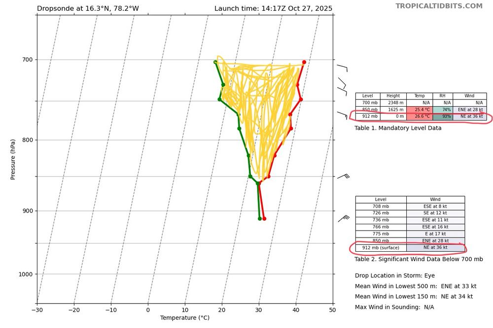
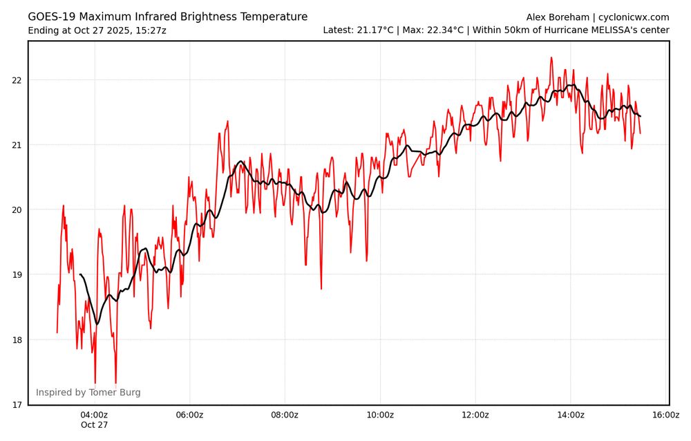
And there we have it. #Melissa's WV eye temperature has broken -5°C, making it warmer than any other eye observed through geostationary water vapor imagery. Takes an upper echelon warm core for this
Reposted
From a crewmember on yesterday's Teal 74 mission into now-Category 5 Hurricane #Melissa. As clear of an eye as you will see in the Atlantic basin.
This is almost certainly far stronger then 165mph that the NHC has right now
The newest Dropsonde is absolute mind boggling, and might be the craziest Dropsonde I have ever seen in a hurricane. We have sustained winds of 163kts recorded at the sfc but not even 10mb off the surface, there are almost 200kts of winds. Even if we count this as a gust, that is ultra impressive
Reposted
Something to watch out for over the next day is precisely where Melissa makes the turn to the north, as do far it continues to drift west or just south of west.

The longer this continues, the farther west its landfall location shifts in Jamaica.
In addition the Southeast #Bahamas and the #Turks&Caicos need to be preparing for a possible hurricane strike on Wednesday with hurricane conditions, life threatening storm surge and heavy rainfall all possible from #Melissa there.
Portions of #Haiti and the #DomincanRepublic and eastern #Cuba need to also be prepared for a significant hurricane strike from #Melissa with heavy rainfall, flash flooding/mudslides and life threatening storm surge/destructive winds likely later this week.
As expected the NHC is using very dire wording that rivals some of the most powerful landfalling hurricanes the Atlantic basin has ever seen. This will be a historic and unprecended event for #Jamaica and prayers go out to everyone there who have a extremely rough next 24-48 hrs ahead
Mutiple dropsondes from the hurricane hunters show this idea very clearly. In the SE eyewall sustained winds were found to be 137kts, but not even 30mb off the surface, there were winds of up over 160kts recorded. There was also a clear temperature spike and a pressure of 908-909mb found in the eye
Both the average WV and IR temperatures has been warming fast over the past 12 hrs, indicating a very healthy system. The more warming/sinking air and subsidence there is in the eye, the more latent heat is being released from the intense thunderstorms in the core of Melissa, lowering sfc pressures