


James Aydelott
@jamesaydelott.bsky.social
He/Him/His
-😍Daddy to 2
-4th Gen Okie
-BS OU Meteorology -MS OkState Emergency Mngmnt
-PhD student OkState Emergency Mngmnt
-Pilot
-Raconteur
-Antagonist
‘Gram: @jamesaydelottwx
Threads: @jamesaydelottwx
-😍Daddy to 2
-4th Gen Okie
-BS OU Meteorology -MS OkState Emergency Mngmnt
-PhD student OkState Emergency Mngmnt
-Pilot
-Raconteur
-Antagonist
‘Gram: @jamesaydelottwx
Threads: @jamesaydelottwx
November 20, 2025 at 5:27 AM
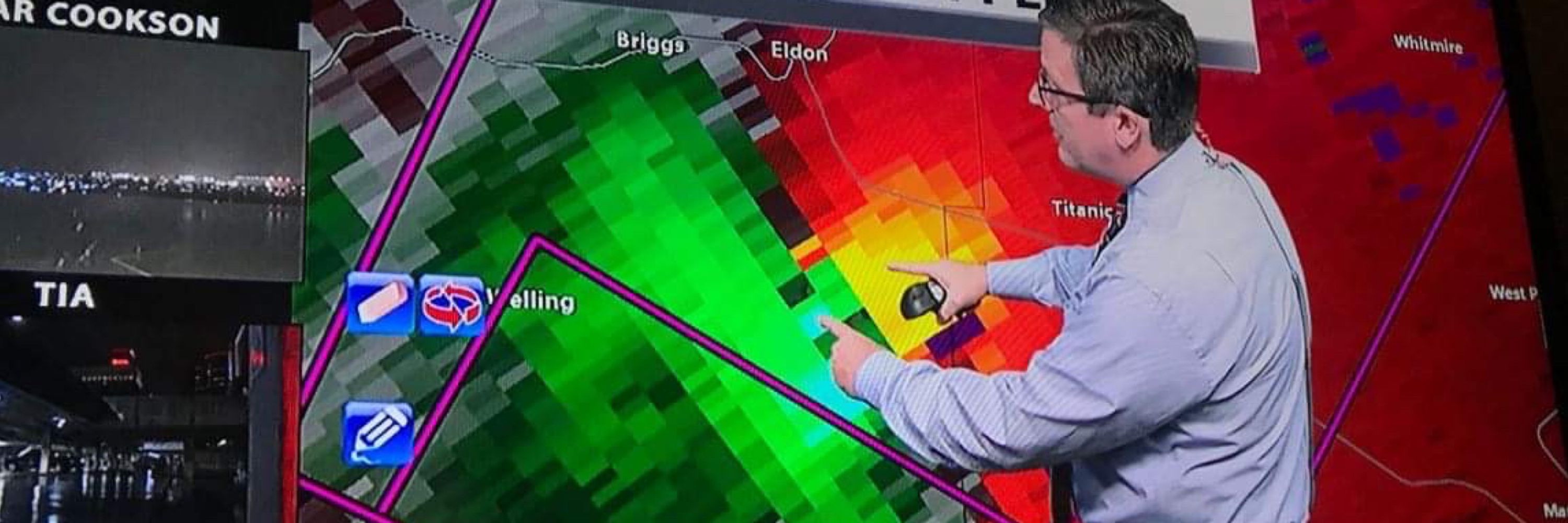
1045pm-Radar update
Severe Storm in SE Washington County, moving NE toward Nowata. Slow weakening trend noted, but still capable of quarter sized hail. No rotation. #okwx
Severe Storm in SE Washington County, moving NE toward Nowata. Slow weakening trend noted, but still capable of quarter sized hail. No rotation. #okwx
November 20, 2025 at 4:46 AM
1045pm-Radar update
Severe Storm in SE Washington County, moving NE toward Nowata. Slow weakening trend noted, but still capable of quarter sized hail. No rotation. #okwx
Severe Storm in SE Washington County, moving NE toward Nowata. Slow weakening trend noted, but still capable of quarter sized hail. No rotation. #okwx
936pm-Radar update
Severe storm moving over Mannford now. Hail up to half-dollar size possible. Post pics of the hail in replies if you can. #okwx
Severe storm moving over Mannford now. Hail up to half-dollar size possible. Post pics of the hail in replies if you can. #okwx
November 20, 2025 at 3:38 AM
936pm-Radar update
Severe storm moving over Mannford now. Hail up to half-dollar size possible. Post pics of the hail in replies if you can. #okwx
Severe storm moving over Mannford now. Hail up to half-dollar size possible. Post pics of the hail in replies if you can. #okwx
Skipperdog noticed the sweaty patio.
Not rain, this happens when winds bring humid air in over cold ground/pavement.
The dewpoint is higher than the ground temp, and that moisture condenses on cooler surfaces.
Usually happens in spring and fall when a humid south wind develops quickly. #okwx
Not rain, this happens when winds bring humid air in over cold ground/pavement.
The dewpoint is higher than the ground temp, and that moisture condenses on cooler surfaces.
Usually happens in spring and fall when a humid south wind develops quickly. #okwx

November 14, 2025 at 5:51 PM
Skipperdog noticed the sweaty patio.
Not rain, this happens when winds bring humid air in over cold ground/pavement.
The dewpoint is higher than the ground temp, and that moisture condenses on cooler surfaces.
Usually happens in spring and fall when a humid south wind develops quickly. #okwx
Not rain, this happens when winds bring humid air in over cold ground/pavement.
The dewpoint is higher than the ground temp, and that moisture condenses on cooler surfaces.
Usually happens in spring and fall when a humid south wind develops quickly. #okwx
Seems about right....

November 13, 2025 at 3:46 AM
Seems about right....
Tulsa/BA drivers:
Crash on the BA Expy at 145th E Ave, Eastbound.
Backup about five miles to 41st Street.
Crash on the BA Expy at 145th E Ave, Eastbound.
Backup about five miles to 41st Street.

November 12, 2025 at 11:44 PM
Tulsa/BA drivers:
Crash on the BA Expy at 145th E Ave, Eastbound.
Backup about five miles to 41st Street.
Crash on the BA Expy at 145th E Ave, Eastbound.
Backup about five miles to 41st Street.
Meanwhile, in SE Wisconsin, the joy of Lake Effect Snow forecasting this week.
High-Resolution satellite shows just how short the distance is from heavy snow to zero! #snOMG
High-Resolution satellite shows just how short the distance is from heavy snow to zero! #snOMG

November 12, 2025 at 8:59 PM
Meanwhile, in SE Wisconsin, the joy of Lake Effect Snow forecasting this week.
High-Resolution satellite shows just how short the distance is from heavy snow to zero! #snOMG
High-Resolution satellite shows just how short the distance is from heavy snow to zero! #snOMG
Currently. Speed 0.
BA Expy eastbound to 169 southbound.
BA Expy eastbound to 169 southbound.


November 12, 2025 at 12:39 AM
Currently. Speed 0.
BA Expy eastbound to 169 southbound.
BA Expy eastbound to 169 southbound.
Tulsa drivers:
Another wreck on the BA Expressway, at I-44, westbound direction.
Tulsa's most poorly designed interchange. Bad idea to have entering traffic, exiting traffic, and a lane ending, all in 1/4 mile. Bad, Bad design that needs to be addressed.
Another wreck on the BA Expressway, at I-44, westbound direction.
Tulsa's most poorly designed interchange. Bad idea to have entering traffic, exiting traffic, and a lane ending, all in 1/4 mile. Bad, Bad design that needs to be addressed.

November 10, 2025 at 11:30 PM
Tulsa drivers:
Another wreck on the BA Expressway, at I-44, westbound direction.
Tulsa's most poorly designed interchange. Bad idea to have entering traffic, exiting traffic, and a lane ending, all in 1/4 mile. Bad, Bad design that needs to be addressed.
Another wreck on the BA Expressway, at I-44, westbound direction.
Tulsa's most poorly designed interchange. Bad idea to have entering traffic, exiting traffic, and a lane ending, all in 1/4 mile. Bad, Bad design that needs to be addressed.
Reposted by James Aydelott

From my house

November 8, 2025 at 11:38 PM
From my house
"We are holding our own."
The last message received from the SS Edmund Fitzgerald OTD in 1975
www.facebook.com/share/p/17gB...
The last message received from the SS Edmund Fitzgerald OTD in 1975
www.facebook.com/share/p/17gB...
Redirecting...
www.facebook.com
November 10, 2025 at 4:21 PM
"We are holding our own."
The last message received from the SS Edmund Fitzgerald OTD in 1975
www.facebook.com/share/p/17gB...
The last message received from the SS Edmund Fitzgerald OTD in 1975
www.facebook.com/share/p/17gB...
hahahahahahahaha
🐀🌶️
🐀🌶️

November 8, 2025 at 12:31 AM
hahahahahahahaha
🐀🌶️
🐀🌶️
This sunset!! Another incredible one! #okwx #TulsaTime

November 8, 2025 at 12:26 AM
This sunset!! Another incredible one! #okwx #TulsaTime
Reposted by James Aydelott
but the lights at Pine and Sheridan have been on a broken timer for 3 years!
November 7, 2025 at 12:03 AM
but the lights at Pine and Sheridan have been on a broken timer for 3 years!

Tulsa drivers:
Traffic signal at 101st and Memorial in South Tulsa is not working for southbound traffic. Huge backup, all the way back to 169/Mingo Rd.
Traffic signal at 101st and Memorial in South Tulsa is not working for southbound traffic. Huge backup, all the way back to 169/Mingo Rd.

November 6, 2025 at 11:02 PM
Tulsa drivers:
Traffic signal at 101st and Memorial in South Tulsa is not working for southbound traffic. Huge backup, all the way back to 169/Mingo Rd.
Traffic signal at 101st and Memorial in South Tulsa is not working for southbound traffic. Huge backup, all the way back to 169/Mingo Rd.
Weathergami for Tulsa..... Because Summer is often so stagnant, our most common high temp/low temp occurrence in our weather records is 93° and 72°. That combo has happened 79 times! from 1938 to 2023.

November 6, 2025 at 10:33 PM
Weathergami for Tulsa..... Because Summer is often so stagnant, our most common high temp/low temp occurrence in our weather records is 93° and 72°. That combo has happened 79 times! from 1938 to 2023.
148pm—
Meteorologists at the @nwsspc are closely monitoring areas along and SE of I-44 for a tornado watch. Conditions still favorable for severe storms and possibly tornado warnings #okwx
Meteorologists at the @nwsspc are closely monitoring areas along and SE of I-44 for a tornado watch. Conditions still favorable for severe storms and possibly tornado warnings #okwx

September 23, 2025 at 6:48 PM
148pm—
Meteorologists at the @nwsspc are closely monitoring areas along and SE of I-44 for a tornado watch. Conditions still favorable for severe storms and possibly tornado warnings #okwx
Meteorologists at the @nwsspc are closely monitoring areas along and SE of I-44 for a tornado watch. Conditions still favorable for severe storms and possibly tornado warnings #okwx
1145am—severe weather update
Upgrade to severe weather and tornado risk. Both have increased.
Impact: hail to 2”, damaging wind, tornadoes possible
Location: Mainly SE of I-44
Timing: developing as early as 3pm near I-44, moving east and into Arkansas by 9pm #okwx
Upgrade to severe weather and tornado risk. Both have increased.
Impact: hail to 2”, damaging wind, tornadoes possible
Location: Mainly SE of I-44
Timing: developing as early as 3pm near I-44, moving east and into Arkansas by 9pm #okwx


September 23, 2025 at 4:47 PM
1145am—severe weather update
Upgrade to severe weather and tornado risk. Both have increased.
Impact: hail to 2”, damaging wind, tornadoes possible
Location: Mainly SE of I-44
Timing: developing as early as 3pm near I-44, moving east and into Arkansas by 9pm #okwx
Upgrade to severe weather and tornado risk. Both have increased.
Impact: hail to 2”, damaging wind, tornadoes possible
Location: Mainly SE of I-44
Timing: developing as early as 3pm near I-44, moving east and into Arkansas by 9pm #okwx