


Florida Tropics
@floridatropics1.bsky.social
Florida Wx throughout the year, with a special focus on the tropics during Hurricane Season. For official information, please refer to the NWS & NHC.
Hurricane season ends today with no impacts to Florida! Let’s carry this energy into 2026 also.
November 30, 2025 at 8:40 PM
Hurricane season ends today with no impacts to Florida! Let’s carry this energy into 2026 also.
Happy Thanksgiving everyone! Enjoy lots of food, family and football today!

a greeting card that says happy thanksgiving
ALT: a greeting card that says happy thanksgiving
media.tenor.com
November 27, 2025 at 12:09 PM
Happy Thanksgiving everyone! Enjoy lots of food, family and football today!
Good morning! Still a very small signal for a potential system at the end of November/early December in the western Caribbean. GFS has been consistent but it may be consistently wrong as usual.


November 23, 2025 at 4:56 PM
Good morning! Still a very small signal for a potential system at the end of November/early December in the western Caribbean. GFS has been consistent but it may be consistently wrong as usual.
It's been a while but here are the 12z ensembles for potential late season activity in the western Caribbean. Low probability but Google showing the chance gives a little more credibility.


November 22, 2025 at 10:37 PM
It's been a while but here are the 12z ensembles for potential late season activity in the western Caribbean. Low probability but Google showing the chance gives a little more credibility.
Today's drought monitor update has introduced exceptional drought (highest level) to portions of Gadsden, Leon, Jefferson and Madison counties. This is the first time since 2012 that exceptional drought conditions have been seen in the state.

November 21, 2025 at 2:19 AM
Today's drought monitor update has introduced exceptional drought (highest level) to portions of Gadsden, Leon, Jefferson and Madison counties. This is the first time since 2012 that exceptional drought conditions have been seen in the state.
Update on the significant pattern change from the Climate Prediction Center.

November 15, 2025 at 1:41 AM
Update on the significant pattern change from the Climate Prediction Center.
Yesterday's drought monitor update expanded the extreme drought in the panhandle, as well as the moderate drought in the Tampa Bay area. No significant rainfall is forecast for the next 7 days.

November 15, 2025 at 1:40 AM
Yesterday's drought monitor update expanded the extreme drought in the panhandle, as well as the moderate drought in the Tampa Bay area. No significant rainfall is forecast for the next 7 days.
Record low temperatures tied in Miami and Naples this morning.


November 11, 2025 at 10:12 PM
Record low temperatures tied in Miami and Naples this morning.
Thank you to our veterans for serving our country! God bless America!

a poster for veterans day with an american flag and stars
ALT: a poster for veterans day with an american flag and stars
media.tenor.com
November 11, 2025 at 5:39 PM
Thank you to our veterans for serving our country! God bless America!
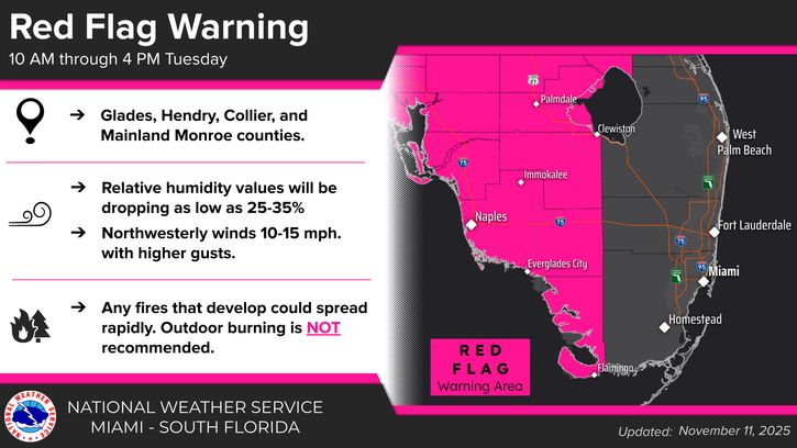
Red Flag Warnings are in effect for much of central and SWFL Florida today. Avoid outdoor burning!

November 11, 2025 at 2:07 PM
Red Flag Warnings are in effect for much of central and SWFL Florida today. Avoid outdoor burning!
From NWS Tampa: numerous record lows tied or broken this morning, including a 133-year-old record in Tampa!

November 11, 2025 at 12:57 PM
From NWS Tampa: numerous record lows tied or broken this morning, including a 133-year-old record in Tampa!
Messaging from NWS Jacksonville, NWS Tampa Bay and NWS Tallahassee regarding the cold weather coming tonight. Protect your plants, pets and pipes!


November 10, 2025 at 2:44 PM
Messaging from NWS Jacksonville, NWS Tampa Bay and NWS Tallahassee regarding the cold weather coming tonight. Protect your plants, pets and pipes!
This is a little ridiculous for November 11 🥶

November 8, 2025 at 2:10 AM
This is a little ridiculous for November 11 🥶
I've seen murmurings about potential development in the Caribbean in the 7-10 day range. Unless Google starts perking up, consider me uninterested.

November 5, 2025 at 9:54 PM
I've seen murmurings about potential development in the Caribbean in the 7-10 day range. Unless Google starts perking up, consider me uninterested.
It's looking to get cold next week. 30s and 40s possible for much of northern and central Florida.

November 5, 2025 at 1:33 PM
It's looking to get cold next week. 30s and 40s possible for much of northern and central Florida.
A nice clean map on today's Global Tropics Hazards Outlook. Less than a month to go in hurricane season!

November 4, 2025 at 7:40 PM
A nice clean map on today's Global Tropics Hazards Outlook. Less than a month to go in hurricane season!
FYI if you have Jamaica vacation plans the next 3 months - a number of Hyatt properties have cancelled reservations through January 2026 due to storm damage from Melissa.

November 1, 2025 at 9:56 PM
FYI if you have Jamaica vacation plans the next 3 months - a number of Hyatt properties have cancelled reservations through January 2026 due to storm damage from Melissa.
Don't forget to change your clocks tonight! We also get the model runs an hour earlier, which is nice!

November 1, 2025 at 1:31 PM
Don't forget to change your clocks tonight! We also get the model runs an hour earlier, which is nice!
Google Deep Mind ensembles showing a very quiet Atlantic for the first 2 weeks of November. Enjoy Halloween!

October 31, 2025 at 9:11 PM
Google Deep Mind ensembles showing a very quiet Atlantic for the first 2 weeks of November. Enjoy Halloween!
The NHC has just issued its last advisory on Hurricane Melissa as it is now a post-tropical cyclone. Safe to say we won't see the name return in 2031.
October 31, 2025 at 2:43 PM
The NHC has just issued its last advisory on Hurricane Melissa as it is now a post-tropical cyclone. Safe to say we won't see the name return in 2031.
Happy Halloween everyone! 🎃 👻
October 31, 2025 at 11:16 AM
Happy Halloween everyone! 🎃 👻
Unsurprising to see Google Deep Mind (GDMI) leading the way this season on track. It’s been on fire. AVNI is the GFS and doing the worst after 72 hours.

October 30, 2025 at 2:06 AM
Unsurprising to see Google Deep Mind (GDMI) leading the way this season on track. It’s been on fire. AVNI is the GFS and doing the worst after 72 hours.
Unbelievable before and after photos from White House and Black River in Jamaica, near where landfall occurred.
📸: Dylan Federico
📸: Dylan Federico

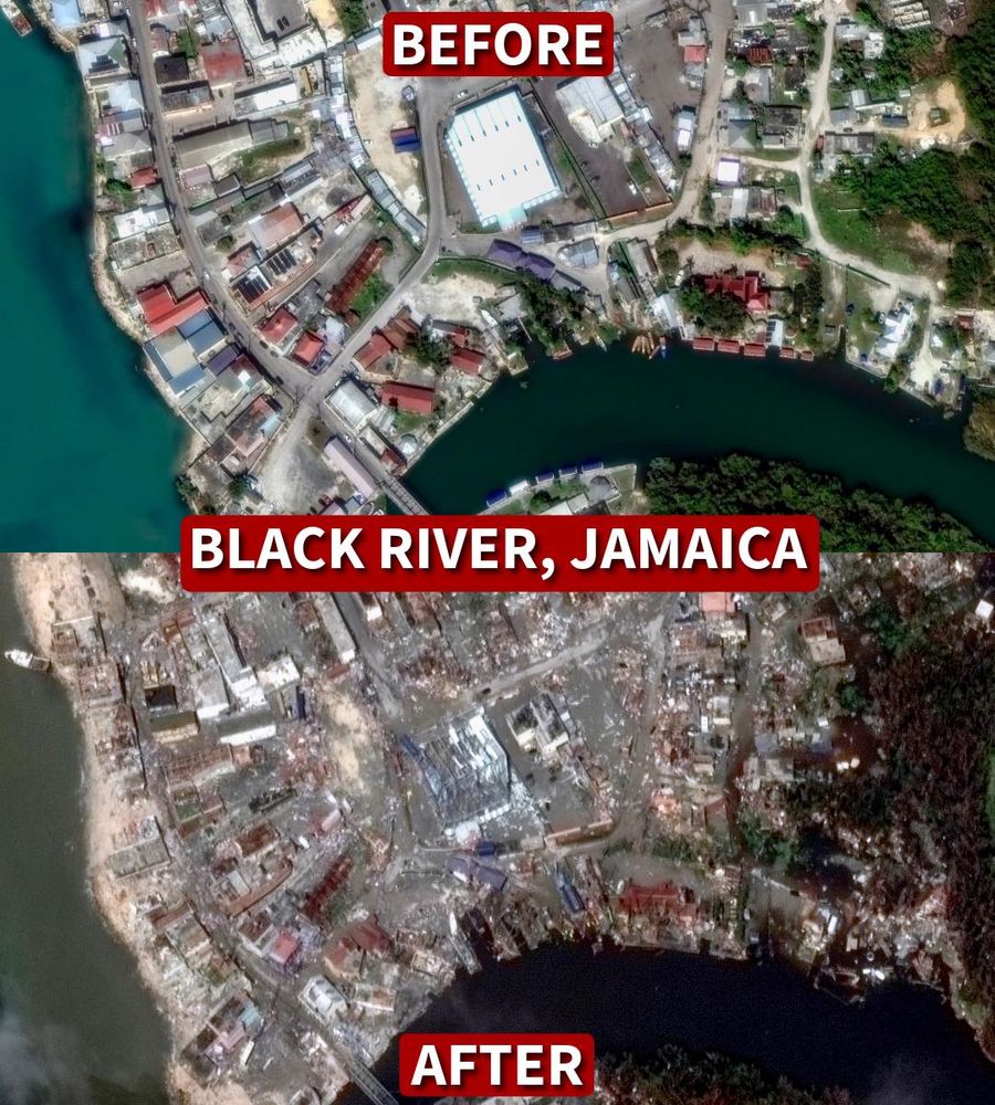
October 29, 2025 at 11:44 PM
Unbelievable before and after photos from White House and Black River in Jamaica, near where landfall occurred.
📸: Dylan Federico
📸: Dylan Federico
Sadly, 54 fatalities have been reported thus far from Melissa in Haiti, Dominican Republic, Jamaica and Panama.
October 29, 2025 at 11:39 PM
Sadly, 54 fatalities have been reported thus far from Melissa in Haiti, Dominican Republic, Jamaica and Panama.
Video from St. Elizabeth Parish in Jamaica showing the aftermath of Hurricane Melissa's landfall.
From X user GiovanniRDennis
From X user GiovanniRDennis
October 29, 2025 at 3:01 PM
Video from St. Elizabeth Parish in Jamaica showing the aftermath of Hurricane Melissa's landfall.
From X user GiovanniRDennis
From X user GiovanniRDennis