


Dave Petley
@davepetley.bsky.social
Vice-Chancellor at the University of Hull in England. Landslides, hazards, risk, vulnerability and resilience, plus a bit of Coventry City. #pusb #Breturn
Reposted by Dave Petley
Impressive rock avalanche on the Dent de Crolles (2062 m asl) in the Chartreuse Massif, French Prealps yesterday 😲
Release area ~1800 m asl
📷 Sylvain Thiabaud
Release area ~1800 m asl
📷 Sylvain Thiabaud

November 29, 2025 at 10:46 AM
Impressive rock avalanche on the Dent de Crolles (2062 m asl) in the Chartreuse Massif, French Prealps yesterday 😲
Release area ~1800 m asl
📷 Sylvain Thiabaud
Release area ~1800 m asl
📷 Sylvain Thiabaud
A somewhat unexpected trip to the CBS for me today. I was supposed to fly to Hong Kong yesterday from Manchester, thwarted by a refuelling truck hitting my aircraft. A very unhelpful #Emirates eventually rebooked me tonight from Heathrow. It would be rude not to take in the match en route! #pusb


November 29, 2025 at 8:12 AM
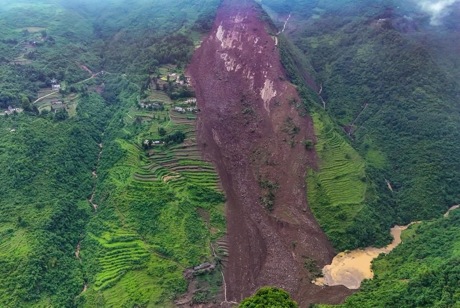
Another tailings storage facility failure has occurred, this time in Mwense District in Zambia.
www.linkedin.com/posts/holy-p...
www.linkedin.com/posts/holy-p...

Another TSF failure in Zambia, Mwense District. | Holy Pola, P.Eng | 21 comments
Another TSF failure in Zambia, Mwense District. | 21 comments on LinkedIn
www.linkedin.com
November 27, 2025 at 6:05 PM
Another tailings storage facility failure has occurred, this time in Mwense District in Zambia.
www.linkedin.com/posts/holy-p...
www.linkedin.com/posts/holy-p...
Over the weekend, @planet.com captured almost perfect satellite imagery of the 4 November 2025 landslide at Mae Moh Mine in Thailand.
eos.org/thelandslide...
eos.org/thelandslide...

Planet imagery of the 4 November 2025 landslide at Mae Moh Mine
Over the weekend, Planet captured almost perfect imagery of the 4 November 2025 landslide at Mae Moh Mine in Thailand.
eos.org
November 24, 2025 at 8:02 AM
Over the weekend, @planet.com captured almost perfect satellite imagery of the 4 November 2025 landslide at Mae Moh Mine in Thailand.
eos.org/thelandslide...
eos.org/thelandslide...
Reposted by Dave Petley

Tune in for tonight's news @ctvnewscalgary.bsky.social (and probably every CTV station across the country) for an interview about landslides. tsunamis, and pipelines. @timmctv.bsky.social ⚒️
I wrote about the under-appreciated hazard of landslide-triggered tsunamis, which need serious consideration in discussions of new pipelines from Alberta 🧪⚒️
@theglobeandmail.com @davidebybc.bsky.social @natural-resources.canada.ca @mark-carney.bsky.social @ucalgaryscience.bsky.social
@theglobeandmail.com @davidebybc.bsky.social @natural-resources.canada.ca @mark-carney.bsky.social @ucalgaryscience.bsky.social

New northwest pipeline risks hazard of landslide tsunamis
Major Projects Office needs to be wary in its planning for pipeline projects to tidewater
www.theglobeandmail.com
November 21, 2025 at 8:05 PM
Tune in for tonight's news @ctvnewscalgary.bsky.social (and probably every CTV station across the country) for an interview about landslides. tsunamis, and pipelines. @timmctv.bsky.social ⚒️
Imagery from @planet.com has captured the 4 November 2025 landslide at Mae Moh Mine in Thailand. It shows the failure was about 4.8 km long and 1.4 km wide. There appears to have been coal waste dumping on the area that failed in the weeks before the landslide.
eos.org/thelandslide...
eos.org/thelandslide...

November 20, 2025 at 8:16 AM
Imagery from @planet.com has captured the 4 November 2025 landslide at Mae Moh Mine in Thailand. It shows the failure was about 4.8 km long and 1.4 km wide. There appears to have been coal waste dumping on the area that failed in the weeks before the landslide.
eos.org/thelandslide...
eos.org/thelandslide...
Reposted by Dave Petley
I wrote about the under-appreciated hazard of landslide-triggered tsunamis, which need serious consideration in discussions of new pipelines from Alberta 🧪⚒️
@theglobeandmail.com @davidebybc.bsky.social @natural-resources.canada.ca @mark-carney.bsky.social @ucalgaryscience.bsky.social
@theglobeandmail.com @davidebybc.bsky.social @natural-resources.canada.ca @mark-carney.bsky.social @ucalgaryscience.bsky.social
New northwest pipeline risks hazard of landslide tsunamis
Major Projects Office needs to be wary in its planning for pipeline projects to tidewater
www.theglobeandmail.com
November 19, 2025 at 5:26 PM
I wrote about the under-appreciated hazard of landslide-triggered tsunamis, which need serious consideration in discussions of new pipelines from Alberta 🧪⚒️
@theglobeandmail.com @davidebybc.bsky.social @natural-resources.canada.ca @mark-carney.bsky.social @ucalgaryscience.bsky.social
@theglobeandmail.com @davidebybc.bsky.social @natural-resources.canada.ca @mark-carney.bsky.social @ucalgaryscience.bsky.social
Satellite imagery from BlackSky shows the aftermath of the 11 November 2025 landslide at Hongqi Bridge in China.
eos.org/thelandslide...
eos.org/thelandslide...

November 17, 2025 at 7:38 AM
Satellite imagery from BlackSky shows the aftermath of the 11 November 2025 landslide at Hongqi Bridge in China.
eos.org/thelandslide...
eos.org/thelandslide...
It's a huge pleasure to be a part of my first #NTU open day today. As always, the students are the stars of the show.
#proudtobeNTU
#proudtobeNTU

November 15, 2025 at 10:00 AM
It's a huge pleasure to be a part of my first #NTU open day today. As always, the students are the stars of the show.
#proudtobeNTU
#proudtobeNTU
Reposted by Dave Petley

🗓️ Artificial Intelligence for Natural Hazards Workshop - Thursday 20th November
Are you an industry or research institution interested in the applications of AI in Earth Observation and natural hazards?
Are you an industry or research institution interested in the applications of AI in Earth Observation and natural hazards?

November 11, 2025 at 12:02 PM
🗓️ Artificial Intelligence for Natural Hazards Workshop - Thursday 20th November
Are you an industry or research institution interested in the applications of AI in Earth Observation and natural hazards?
Are you an industry or research institution interested in the applications of AI in Earth Observation and natural hazards?
On 11 November 2025, a massive landslide at Hongqi Bridge in Sichuan Province, China occurred during impoundment of the 312 m high Shuangjiangkou Dam. A major highway bridge was destroyed.
eos.org/thelandslide...
eos.org/thelandslide...

The 11 November 2025 landslide at Hongqi Bridge in China
The 11 November 2025 landslide at Hongqi Bridge in China. This occurred during impoundment of the 312 m high Shuangjiangkou Dam.
eos.org
November 14, 2025 at 8:28 AM
On 11 November 2025, a massive landslide at Hongqi Bridge in Sichuan Province, China occurred during impoundment of the 312 m high Shuangjiangkou Dam. A major highway bridge was destroyed.
eos.org/thelandslide...
eos.org/thelandslide...
In #Sheffield, someone has had a bad morning. Completely stuck, blocking the tram tracks. They've driven over 100 metres off road along the tracks to get to this point.

November 13, 2025 at 7:14 AM
In #Sheffield, someone has had a bad morning. Completely stuck, blocking the tram tracks. They've driven over 100 metres off road along the tracks to get to this point.
In August 2025, I recorded 104 fatal landslides, a record total number of landslides for August. 2025 is shaping up to be a terrible year for fatal landslides, with the cumulative total to that point being close to the highest year, in 2024.
eos.org/thelandslide...
eos.org/thelandslide...

November 11, 2025 at 7:15 AM
In August 2025, I recorded 104 fatal landslides, a record total number of landslides for August. 2025 is shaping up to be a terrible year for fatal landslides, with the cumulative total to that point being close to the highest year, in 2024.
eos.org/thelandslide...
eos.org/thelandslide...
A new paper in the journal Geoarchaeology (Garcia et al, 2025) hypothesises that an earthquake-induced debris flow in about 900 AD may have played a role in the abandonment of the archaeological site at Pikillaqta in Peru.
eos.org/thelandslide...
eos.org/thelandslide...

November 10, 2025 at 7:51 AM
A new paper in the journal Geoarchaeology (Garcia et al, 2025) hypothesises that an earthquake-induced debris flow in about 900 AD may have played a role in the abandonment of the archaeological site at Pikillaqta in Peru.
eos.org/thelandslide...
eos.org/thelandslide...
On 4 November 2025, a very large landslide in a coal waste slope at Mae Moh Mine in Thailand, causing extensive damage.
It appears that the landslide was associated with very heavy rainfall.
eos.org/thelandslide...
It appears that the landslide was associated with very heavy rainfall.
eos.org/thelandslide...

November 7, 2025 at 8:41 AM
On 4 November 2025, a very large landslide in a coal waste slope at Mae Moh Mine in Thailand, causing extensive damage.
It appears that the landslide was associated with very heavy rainfall.
eos.org/thelandslide...
It appears that the landslide was associated with very heavy rainfall.
eos.org/thelandslide...
This enormous landslide occurred at the Mae Moh mine in Thailand at about 3 am on 4 November 2025. The trigger appears to have been heavy rainfall. Mae Moh is an enormous mine site at [18.3422, 99.7279].
The image was released by the operator, EGAT.
The image was released by the operator, EGAT.

November 5, 2025 at 8:06 AM
This enormous landslide occurred at the Mae Moh mine in Thailand at about 3 am on 4 November 2025. The trigger appears to have been heavy rainfall. Mae Moh is an enormous mine site at [18.3422, 99.7279].
The image was released by the operator, EGAT.
The image was released by the operator, EGAT.
Satellite images from @Planet show the series of debris flows on 31 October 2025 at Chesongoch in Kenya, which killed about 50 people.
eos.org/thelandslide...
eos.org/thelandslide...

November 4, 2025 at 8:06 AM
Satellite images from @Planet show the series of debris flows on 31 October 2025 at Chesongoch in Kenya, which killed about 50 people.
eos.org/thelandslide...
eos.org/thelandslide...
A train has derailed near to Shap in Cumbria in northern England after it struck a landslide. Fortunately, it remained upright, so there is no loss of life. Some people have suffered minor injuries.
www.bbc.co.uk/news/live/cz...
www.bbc.co.uk/news/live/cz...

West Coast Main Line: Train derails in Cumbria with 'days' of disruption expected
The train was carrying around 85 passengers when it derailed at 06:10 - Avanti West Coast advises customers not to travel north of Preston today.
www.bbc.co.uk
November 3, 2025 at 12:47 PM
A train has derailed near to Shap in Cumbria in northern England after it struck a landslide. Fortunately, it remained upright, so there is no loss of life. Some people have suffered minor injuries.
www.bbc.co.uk/news/live/cz...
www.bbc.co.uk/news/live/cz...
Reposted by Dave Petley
Holy moly - this glacier detachment in Tajikistan is WILD. It appears that there was a large piece of glacier ice much farther down the valley from a first detachment which then got pushed by a second soon thereafter. 🧵@planet.com @davepetley.bsky.social 🧪⚒️
November 1, 2025 at 2:07 PM
Holy moly - this glacier detachment in Tajikistan is WILD. It appears that there was a large piece of glacier ice much farther down the valley from a first detachment which then got pushed by a second soon thereafter. 🧵@planet.com @davepetley.bsky.social 🧪⚒️
Some videos have emerged from Afghanistan, reportedly showing landslides and rockfalls triggered by the M=6.3 earthquake early this morning. The road between Mazar and Kabul is reportedly blocked, which will impact the delivery of emergency assistance.
eos.org/thelandslide...
eos.org/thelandslide...

November 3, 2025 at 7:40 AM
Some videos have emerged from Afghanistan, reportedly showing landslides and rockfalls triggered by the M=6.3 earthquake early this morning. The road between Mazar and Kabul is reportedly blocked, which will impact the delivery of emergency assistance.
eos.org/thelandslide...
eos.org/thelandslide...

On 31 October 2025, a landslide occurred at Kukas in Enga Province, Papua New Guinea, triggered by heavy rainfall at about 2 am. Reports indicate that at least 22 people were killed. This image, from Facebook, suggests that it occurred in a steep gully.
eos.org/thelandslide...
eos.org/thelandslide...

October 31, 2025 at 8:09 AM
On 31 October 2025, a landslide occurred at Kukas in Enga Province, Papua New Guinea, triggered by heavy rainfall at about 2 am. Reports indicate that at least 22 people were killed. This image, from Facebook, suggests that it occurred in a steep gully.
eos.org/thelandslide...
eos.org/thelandslide...
On 22 May 2025, the 1.4 million cubic metre Qingyang landslide in Guizhou Province, China killed 19 people. A new paper in the journal Landslides (Wen et al. 2025) shows that adverse geological conditions caused the landslide, and heavy rainfall was the trigger.
eos.org/thelandslide...
eos.org/thelandslide...
October 30, 2025 at 7:58 AM
On 22 May 2025, the 1.4 million cubic metre Qingyang landslide in Guizhou Province, China killed 19 people. A new paper in the journal Landslides (Wen et al. 2025) shows that adverse geological conditions caused the landslide, and heavy rainfall was the trigger.
eos.org/thelandslide...
eos.org/thelandslide...
Reposted by Dave Petley
UTTERLY SURREAL LOW ANGLE GLACIER SLIDE!! 😮😱
On Saturday at 11:00 am, a 2 km-long, 25 m-high, and 150-200 m in width section detached off the Ismoil Somoni Glacier (Tajikistan) and slid down the gorge! 🧊🌊
asiaplustj.info/en/node/354309
📽️ via @volcaholic1
On Saturday at 11:00 am, a 2 km-long, 25 m-high, and 150-200 m in width section detached off the Ismoil Somoni Glacier (Tajikistan) and slid down the gorge! 🧊🌊
asiaplustj.info/en/node/354309
📽️ via @volcaholic1
October 28, 2025 at 4:10 PM
UTTERLY SURREAL LOW ANGLE GLACIER SLIDE!! 😮😱
On Saturday at 11:00 am, a 2 km-long, 25 m-high, and 150-200 m in width section detached off the Ismoil Somoni Glacier (Tajikistan) and slid down the gorge! 🧊🌊
asiaplustj.info/en/node/354309
📽️ via @volcaholic1
On Saturday at 11:00 am, a 2 km-long, 25 m-high, and 150-200 m in width section detached off the Ismoil Somoni Glacier (Tajikistan) and slid down the gorge! 🧊🌊
asiaplustj.info/en/node/354309
📽️ via @volcaholic1
Reposted by Dave Petley
While most eyes are on Jamaica and #HurricaneMelissa, central Vietnam just received over 1m of rain (>39”) in 24 hours

Vietnam's weather agency has recorded its highest level of rainfall for a 24-hour period in the historic city of Hue.

Record rains drive flooding in Vietnam, submerging ancient city
Vietnam's weather agency has recorded its highest level of rainfall for a 24-hour period in the historic city of Hue.
bit.ly
October 28, 2025 at 2:48 PM
While most eyes are on Jamaica and #HurricaneMelissa, central Vietnam just received over 1m of rain (>39”) in 24 hours