


CanwarnQC VE2CWQ
@canwarnqc.bsky.social
Ce site est consacré à la météorologie. Nous sommes un club radioamateur qui lors de temps violent diffusons des réseaux météo à travers tout le Québec sur les ondes VHF/UHF et HF. www.ve2cwq.ca
Reposted by CanwarnQC VE2CWQ
Le @washingtonpost.com a attiré mon attention :
❄️ 𝐀𝐥𝐞𝐫𝐭𝐞 𝐌𝐞́𝐭𝐞́𝐨 : 𝐍𝐨𝐬 𝐬𝐞𝐧𝐭𝐢𝐧𝐞𝐥𝐥𝐞𝐬 𝐬𝐨𝐧𝐭 𝐚̀ 𝐛𝐨𝐮𝐭 ! ⚠️
"L'hiver est là, mais le @nws.noaa.gov aux États-Unis n'a jamais été aussi mal préparé. Nos météorologues experts en prévisions sont en grave sous-effectif dans plus d'une demi-douzaine d'États !
❄️ 𝐀𝐥𝐞𝐫𝐭𝐞 𝐌𝐞́𝐭𝐞́𝐨 : 𝐍𝐨𝐬 𝐬𝐞𝐧𝐭𝐢𝐧𝐞𝐥𝐥𝐞𝐬 𝐬𝐨𝐧𝐭 𝐚̀ 𝐛𝐨𝐮𝐭 ! ⚠️
"L'hiver est là, mais le @nws.noaa.gov aux États-Unis n'a jamais été aussi mal préparé. Nos météorologues experts en prévisions sont en grave sous-effectif dans plus d'une demi-douzaine d'États !
December 7, 2025 at 2:59 PM
Le @washingtonpost.com a attiré mon attention :
❄️ 𝐀𝐥𝐞𝐫𝐭𝐞 𝐌𝐞́𝐭𝐞́𝐨 : 𝐍𝐨𝐬 𝐬𝐞𝐧𝐭𝐢𝐧𝐞𝐥𝐥𝐞𝐬 𝐬𝐨𝐧𝐭 𝐚̀ 𝐛𝐨𝐮𝐭 ! ⚠️
"L'hiver est là, mais le @nws.noaa.gov aux États-Unis n'a jamais été aussi mal préparé. Nos météorologues experts en prévisions sont en grave sous-effectif dans plus d'une demi-douzaine d'États !
❄️ 𝐀𝐥𝐞𝐫𝐭𝐞 𝐌𝐞́𝐭𝐞́𝐨 : 𝐍𝐨𝐬 𝐬𝐞𝐧𝐭𝐢𝐧𝐞𝐥𝐥𝐞𝐬 𝐬𝐨𝐧𝐭 𝐚̀ 𝐛𝐨𝐮𝐭 ! ⚠️
"L'hiver est là, mais le @nws.noaa.gov aux États-Unis n'a jamais été aussi mal préparé. Nos météorologues experts en prévisions sont en grave sous-effectif dans plus d'une demi-douzaine d'États !
Reposted by CanwarnQC VE2CWQ
𝗖'𝗲𝘀𝘁 𝗰𝗿𝗶𝘁𝗶𝗾𝘂𝗲 :
➡️ Certains bureaux (Goodland, Kansas), près de 1/2 des postes de météorologue sont vacants.
➡️Le bureau du Kansas a dû arrêter ses prévisions 24h/24 faute de personnel!
➡️Des spécialistes essentiels pour aviser des dangers, gérer les crues et déployer les ressources d'urgence.
➡️ Certains bureaux (Goodland, Kansas), près de 1/2 des postes de météorologue sont vacants.
➡️Le bureau du Kansas a dû arrêter ses prévisions 24h/24 faute de personnel!
➡️Des spécialistes essentiels pour aviser des dangers, gérer les crues et déployer les ressources d'urgence.
December 7, 2025 at 2:59 PM
𝗖'𝗲𝘀𝘁 𝗰𝗿𝗶𝘁𝗶𝗾𝘂𝗲 :
➡️ Certains bureaux (Goodland, Kansas), près de 1/2 des postes de météorologue sont vacants.
➡️Le bureau du Kansas a dû arrêter ses prévisions 24h/24 faute de personnel!
➡️Des spécialistes essentiels pour aviser des dangers, gérer les crues et déployer les ressources d'urgence.
➡️ Certains bureaux (Goodland, Kansas), près de 1/2 des postes de météorologue sont vacants.
➡️Le bureau du Kansas a dû arrêter ses prévisions 24h/24 faute de personnel!
➡️Des spécialistes essentiels pour aviser des dangers, gérer les crues et déployer les ressources d'urgence.
Reposted by CanwarnQC VE2CWQ
𝗣𝗼𝘂𝗿𝗾𝘂𝗼𝗶 𝗰'𝗲𝘀𝘁 𝗶𝗻𝗾𝘂𝗶𝗲́𝘁𝗮𝗻𝘁 ? 👇
Les tempêtes hivernales sont souvent sous-estimées, mais elles peuvent être mortelles. Les experts craignent qu'en cas de forte tempête, la pénurie actuelle ne se traduise par des dommages et des pertes de vie plus importants.
Les tempêtes hivernales sont souvent sous-estimées, mais elles peuvent être mortelles. Les experts craignent qu'en cas de forte tempête, la pénurie actuelle ne se traduise par des dommages et des pertes de vie plus importants.
December 7, 2025 at 2:59 PM
𝗣𝗼𝘂𝗿𝗾𝘂𝗼𝗶 𝗰'𝗲𝘀𝘁 𝗶𝗻𝗾𝘂𝗶𝗲́𝘁𝗮𝗻𝘁 ? 👇
Les tempêtes hivernales sont souvent sous-estimées, mais elles peuvent être mortelles. Les experts craignent qu'en cas de forte tempête, la pénurie actuelle ne se traduise par des dommages et des pertes de vie plus importants.
Les tempêtes hivernales sont souvent sous-estimées, mais elles peuvent être mortelles. Les experts craignent qu'en cas de forte tempête, la pénurie actuelle ne se traduise par des dommages et des pertes de vie plus importants.
Reposted by CanwarnQC VE2CWQ
Les employés restants sont épuisés et font face à un stress immense. Un employé a dit : « Nous sommes comme une voiture qui manque lentement d'essence. Nous roulons encore, mais on sait que ça ne durera pas éternellement. »
Prudence cet hiver, car l'équipe qui veille sur nous est en mode survie. 🙏
Prudence cet hiver, car l'équipe qui veille sur nous est en mode survie. 🙏
December 7, 2025 at 2:59 PM
Les employés restants sont épuisés et font face à un stress immense. Un employé a dit : « Nous sommes comme une voiture qui manque lentement d'essence. Nous roulons encore, mais on sait que ça ne durera pas éternellement. »
Prudence cet hiver, car l'équipe qui veille sur nous est en mode survie. 🙏
Prudence cet hiver, car l'équipe qui veille sur nous est en mode survie. 🙏
À Schefferville aujourd'hui, on observe un parhélie, ou un "faux soleil". Un phénomène de réfraction de la lumière solaire sur les cristaux de glace de l'atmosphère, qui résulte en deux répliques de l'image du soleil de part et d'autre de celui-ci! 📷
@navcanada
#meteoQC Source: ECCC Météo Québec
@navcanada
#meteoQC Source: ECCC Météo Québec

December 6, 2025 at 2:42 PM
À Schefferville aujourd'hui, on observe un parhélie, ou un "faux soleil". Un phénomène de réfraction de la lumière solaire sur les cristaux de glace de l'atmosphère, qui résulte en deux répliques de l'image du soleil de part et d'autre de celui-ci! 📷
@navcanada
#meteoQC Source: ECCC Météo Québec
@navcanada
#meteoQC Source: ECCC Météo Québec
Une Metnote est en vigueur concernant le froid de cette nuit. Veuillez consulter notre site internet pour plus de précisions. ow.ly/VRMH50XCb8f
#meteoQC Source: EC
#meteoQC Source: EC

December 4, 2025 at 10:25 PM
Une Metnote est en vigueur concernant le froid de cette nuit. Veuillez consulter notre site internet pour plus de précisions. ow.ly/VRMH50XCb8f
#meteoQC Source: EC
#meteoQC Source: EC
Reposted by CanwarnQC VE2CWQ

Original post: mastodon.hams.social/@VE6LK/11565...

December 3, 2025 at 3:17 AM
Original post: mastodon.hams.social/@VE6LK/11565...
Reposted by CanwarnQC VE2CWQ

Precipitation over the next week looks to focus across the Pac NW and Gulf Coast regions with a decent soaking for each, along with lake effect precipitation falling downwind of the Great Lakes. What's in store for you? Check it out at weather.gov

December 3, 2025 at 4:26 PM
Precipitation over the next week looks to focus across the Pac NW and Gulf Coast regions with a decent soaking for each, along with lake effect precipitation falling downwind of the Great Lakes. What's in store for you? Check it out at weather.gov
Reposted by CanwarnQC VE2CWQ
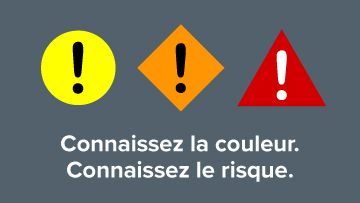
💡 Fini les seuils chiffrés!
Voici comment les nouvelles alertes météo colorées d'ECCC vont vous protéger.
C'est un changement historique!
Environnement et Changement climatique Canada (ECCC) lance un nouveau système d'alertes par codes de couleur pour les phénomènes extrêmes.
Voici comment les nouvelles alertes météo colorées d'ECCC vont vous protéger.
C'est un changement historique!
Environnement et Changement climatique Canada (ECCC) lance un nouveau système d'alertes par codes de couleur pour les phénomènes extrêmes.
November 27, 2025 at 10:38 PM
💡 Fini les seuils chiffrés!
Voici comment les nouvelles alertes météo colorées d'ECCC vont vous protéger.
C'est un changement historique!
Environnement et Changement climatique Canada (ECCC) lance un nouveau système d'alertes par codes de couleur pour les phénomènes extrêmes.
Voici comment les nouvelles alertes météo colorées d'ECCC vont vous protéger.
C'est un changement historique!
Environnement et Changement climatique Canada (ECCC) lance un nouveau système d'alertes par codes de couleur pour les phénomènes extrêmes.
Reposted by CanwarnQC VE2CWQ
👉 Le nouveau facteur clé : la vulnérabilité régionale. 🗺️
Le même verglas (ex. : 10 mm) n'aura pas la même couleur selon si vous êtes dans une région avec des infrastructures modernes ou une zone très vulnérable.
Les météorologues croisent maintenant les données chiffrées avec cette vulnérabilité.
Le même verglas (ex. : 10 mm) n'aura pas la même couleur selon si vous êtes dans une région avec des infrastructures modernes ou une zone très vulnérable.
Les météorologues croisent maintenant les données chiffrées avec cette vulnérabilité.

November 27, 2025 at 10:38 PM
👉 Le nouveau facteur clé : la vulnérabilité régionale. 🗺️
Le même verglas (ex. : 10 mm) n'aura pas la même couleur selon si vous êtes dans une région avec des infrastructures modernes ou une zone très vulnérable.
Les météorologues croisent maintenant les données chiffrées avec cette vulnérabilité.
Le même verglas (ex. : 10 mm) n'aura pas la même couleur selon si vous êtes dans une région avec des infrastructures modernes ou une zone très vulnérable.
Les météorologues croisent maintenant les données chiffrées avec cette vulnérabilité.
Reposted by CanwarnQC VE2CWQ
Le choix de la couleur dépendra de deux facteurs cruciaux:
1- L'impact potentiel sur les gens, les biens et les collectivités.
2- Le degré de confiance des météorologues dans la prévision.
Rappel : Lisez toujours le texte complet de l'alerte pour les mesures de sécurité spécifiques!
1- L'impact potentiel sur les gens, les biens et les collectivités.
2- Le degré de confiance des météorologues dans la prévision.
Rappel : Lisez toujours le texte complet de l'alerte pour les mesures de sécurité spécifiques!

November 27, 2025 at 10:38 PM
Le choix de la couleur dépendra de deux facteurs cruciaux:
1- L'impact potentiel sur les gens, les biens et les collectivités.
2- Le degré de confiance des météorologues dans la prévision.
Rappel : Lisez toujours le texte complet de l'alerte pour les mesures de sécurité spécifiques!
1- L'impact potentiel sur les gens, les biens et les collectivités.
2- Le degré de confiance des météorologues dans la prévision.
Rappel : Lisez toujours le texte complet de l'alerte pour les mesures de sécurité spécifiques!
Reposted by CanwarnQC VE2CWQ

MISE EN GARD DE NEIGE ABONDANTE publiée par Météo Laurentides pour le secteur CENTRE des Laurentides. Tous les détails au www.meteolaurentides.com

November 29, 2025 at 5:31 PM
MISE EN GARD DE NEIGE ABONDANTE publiée par Météo Laurentides pour le secteur CENTRE des Laurentides. Tous les détails au www.meteolaurentides.com
Reposted by CanwarnQC VE2CWQ

Les passagers de JetBlue ont eu chaud 😨 https://ow.ly/Zk8850XzvN6

Tempêtes solaires : des vols affectés - MétéoMédia
Un avion qui plonge soudainement, des vols retardés… Le Soleil en fait voir de toutes les couleurs aux compagnies aériennes depuis quelques semaines.
ow.ly
November 29, 2025 at 11:46 PM
Les passagers de JetBlue ont eu chaud 😨 https://ow.ly/Zk8850XzvN6
Reposted by CanwarnQC VE2CWQ
Les conditions routières sont à surveiller ce dimanche. Tous les détails. ❄️🚗
https://ow.ly/VbAO50XzK57
#meteoqc #neige #bordee #conditionsroutieres
https://ow.ly/VbAO50XzK57
#meteoqc #neige #bordee #conditionsroutieres
Jusqu’à 20 cm de neige dimanche : voyez ce qui attend votre secteur - MétéoMédia
La neige pourrait compliquer les déplacements, ce dimanche, alors que des accumulations allant jusqu’à 20 cm sont possibles pour certaines régions du Québec. Prévision.
ow.ly
November 30, 2025 at 1:36 PM
Les conditions routières sont à surveiller ce dimanche. Tous les détails. ❄️🚗
https://ow.ly/VbAO50XzK57
#meteoqc #neige #bordee #conditionsroutieres
https://ow.ly/VbAO50XzK57
#meteoqc #neige #bordee #conditionsroutieres
Reposted by CanwarnQC VE2CWQ
La Niña est là… mais en sourdine. Cet hiver, d’autres forces pourraient bien dicter la météo au Québec. Découvrez lesquelles.
https://ow.ly/akjy50XsnSE
#LaNiña #MétéoQuébec #PrévisionsMétéo #Météo
https://ow.ly/akjy50XsnSE
#LaNiña #MétéoQuébec #PrévisionsMétéo #Météo

La Niña faible : quels impacts pour l’hiver au Québec? - MétéoMédia
La Niña est bel et bien installée dans le Pacifique, mais dans une version faible, ce qui rend son influence plus discrète. Vortex polaire, canicule marine, blocage atmosphérique : cet hiver, le Québec pourrait davantage ressentir les effets d’autres acteurs climatiques majeurs.
ow.ly
November 16, 2025 at 7:16 PM
La Niña est là… mais en sourdine. Cet hiver, d’autres forces pourraient bien dicter la météo au Québec. Découvrez lesquelles.
https://ow.ly/akjy50XsnSE
#LaNiña #MétéoQuébec #PrévisionsMétéo #Météo
https://ow.ly/akjy50XsnSE
#LaNiña #MétéoQuébec #PrévisionsMétéo #Météo
Reposted by CanwarnQC VE2CWQ
Jusqu'à 20 cm de neige et 40 mm de pluie par endroits, d'ici lundi soir. Tous les détails. ❄️☔
https://ow.ly/NlLi50XsmaJ
#meteoqc #neige #pluie
https://ow.ly/NlLi50XsmaJ
#meteoqc #neige #pluie

La neige se poursuit et une finale en pluie pour ces secteurs - MétéoMédia
Si l’ouest et le sud de la province ont particulièrement goûté aux foudres hivernales de Mère Nature pour débuter le week-end, le système a désormais d’autres cibles dans sa mire. De la neige, mais aussi de la pluie sont au rendez-vous, d’ici lundi soir. Prévision.
ow.ly
November 16, 2025 at 2:10 PM
Jusqu'à 20 cm de neige et 40 mm de pluie par endroits, d'ici lundi soir. Tous les détails. ❄️☔
https://ow.ly/NlLi50XsmaJ
#meteoqc #neige #pluie
https://ow.ly/NlLi50XsmaJ
#meteoqc #neige #pluie
Jusqu'à 20 cm de neige et jusqu'à 15 mm de pluie verglaçante sont attendus de samedi soir à dimanche sur certains secteurs. Consultez les alertes ici : ow.ly/NUxA50Xs0VJ #meteoQC Source: Env.Canada

November 15, 2025 at 5:20 AM
Jusqu'à 20 cm de neige et jusqu'à 15 mm de pluie verglaçante sont attendus de samedi soir à dimanche sur certains secteurs. Consultez les alertes ici : ow.ly/NUxA50Xs0VJ #meteoQC Source: Env.Canada
Reposted by CanwarnQC VE2CWQ

Reposted by CanwarnQC VE2CWQ
Une station allemande secrète au Labrador a été découverte en 1977
https://ow.ly/2ZEa50Xq3rZ
https://ow.ly/2ZEa50Xq3rZ

Les nazis avaient une station météo secrèete tout près du Québec - MétéoMédia
Durant la seconde guerre mondiale, les nazis sont débarqués à quelques kilomètres du Québec. Mais on a découvert leur présence que 35 ans plus tard. Voici la fascinante histoire d’une station météo secrète.
ow.ly
November 11, 2025 at 4:21 PM
Une station allemande secrète au Labrador a été découverte en 1977
https://ow.ly/2ZEa50Xq3rZ
https://ow.ly/2ZEa50Xq3rZ
Reposted by CanwarnQC VE2CWQ

Qui dit #panne d’électricité comme celle de cette semaine dit aussi beaucoup d’activité sur nos médias sociaux.
C’est sous cet angle des questions posées par le public sur nos plateformes que l’équipe de « On va se le dire » à @info.radio-canada.ca a orienté l’entrevue que nous leur avons accordée.
C’est sous cet angle des questions posées par le public sur nos plateformes que l’équipe de « On va se le dire » à @info.radio-canada.ca a orienté l’entrevue que nous leur avons accordée.

4 questions au sujet des pannes d’électricité | On va se le dire
Pourquoi tant de pannes dès la première tempête de neige?
ici.radio-canada.ca
November 14, 2025 at 8:58 PM
Qui dit #panne d’électricité comme celle de cette semaine dit aussi beaucoup d’activité sur nos médias sociaux.
C’est sous cet angle des questions posées par le public sur nos plateformes que l’équipe de « On va se le dire » à @info.radio-canada.ca a orienté l’entrevue que nous leur avons accordée.
C’est sous cet angle des questions posées par le public sur nos plateformes que l’équipe de « On va se le dire » à @info.radio-canada.ca a orienté l’entrevue que nous leur avons accordée.
Reposted by CanwarnQC VE2CWQ
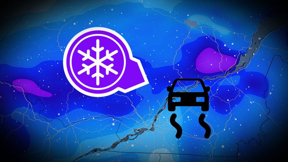
Avec des températures qui oscillent autour de 0 °C, il suffit de peu pour passer d'une chaussée mouillée à une patinoire. https://ow.ly/q1Oe50Xs19u #MétéoQc

Verglas et neige : les risques à surveiller - MétéoMédia
Les prochains jours s’annoncent délicats sur les routes du Québec. Un système venu du nord-ouest apportera un cocktail météo : neige, pluie verglaçante, grésil et pluie pourraient se succéder selon les secteurs et parfois varier sur quelques kilomètres seulement. Avec des températures qui oscillent autour de 0 °C, plusieurs facteurs pourraient faire la différence entre chaussée mouillée, glacée ou enneigée.
ow.ly
November 14, 2025 at 10:53 PM
Avec des températures qui oscillent autour de 0 °C, il suffit de peu pour passer d'une chaussée mouillée à une patinoire. https://ow.ly/q1Oe50Xs19u #MétéoQc
Le soleil a produit un gros X-Flare vers la terre, les chances d’aurores boréales seront fortes lors des deux prochaines nuits.
Mais les chances de nuages aussi, sur pas mal toutes la province 😑.
Citation
NOAA Space Weather Prediction Center
@NWSSWPC
Source: Pierre-Marc Doucet
Mais les chances de nuages aussi, sur pas mal toutes la province 😑.
Citation
NOAA Space Weather Prediction Center
@NWSSWPC
Source: Pierre-Marc Doucet

November 11, 2025 at 7:40 PM
Le soleil a produit un gros X-Flare vers la terre, les chances d’aurores boréales seront fortes lors des deux prochaines nuits.
Mais les chances de nuages aussi, sur pas mal toutes la province 😑.
Citation
NOAA Space Weather Prediction Center
@NWSSWPC
Source: Pierre-Marc Doucet
Mais les chances de nuages aussi, sur pas mal toutes la province 😑.
Citation
NOAA Space Weather Prediction Center
@NWSSWPC
Source: Pierre-Marc Doucet
À la suite de la neige de dimanche, une deuxième impulsion a apporté des accumulations supplémentaires depuis lundi soir sur le sud et le centre de la province. Cela a causé de nombreuses pannes de courant dans plusieurs régions. #meteoQC Source: Env.Canada

November 11, 2025 at 7:36 PM
À la suite de la neige de dimanche, une deuxième impulsion a apporté des accumulations supplémentaires depuis lundi soir sur le sud et le centre de la province. Cela a causé de nombreuses pannes de courant dans plusieurs régions. #meteoQC Source: Env.Canada
Reposted by CanwarnQC VE2CWQ
Les conditions météorologiques des dernières heures causent des #pannes dans plusieurs régions du Québec. La neige mouillée et lourde, accompagnée de vents forts a fragilisé la végétation qui tombe sur le réseau. Montréal et la Montérégie sont les régions les plus touchées.
November 11, 2025 at 3:19 AM
Les conditions météorologiques des dernières heures causent des #pannes dans plusieurs régions du Québec. La neige mouillée et lourde, accompagnée de vents forts a fragilisé la végétation qui tombe sur le réseau. Montréal et la Montérégie sont les régions les plus touchées.
