Keshab Thapa
banner
naksaa.bsky.social
Keshab Thapa
@naksaa.bsky.social
21 followers 33 following 36 posts
I love maps and mapping from the decolonizing lens, two-eyed seeing, and Indigenous land stewardship. I live in the Treaty One Native land on Turtle Island. I grew up in a rural village in Western Nepal. I use both open source GIS and Esri’s GIS.
Posts Media Videos Starter Packs
A video about using ArcGIS living atlas in ArcGIS Pro:
How to Use Esri's Living Atlas in ArcGIS Pro
youtu.be/ZroXEbE1tP0
How to Use Esri's Living Atlas in ArcGIS Pro
YouTube video by GIS Writes
youtu.be
Sonam Wangchuk from Ladakh is a climate activist and scientist, not a criminal. He is detained in jail with no valid reasons. Aren’t the Indian Government’s democratic values in question? #sonamwangchuk #justiceforsonamwangchuk
Most UN member states have failed to meet their biodiversity targets over the last two decades, marking two notable failures. In this paper, we discuss how Indigenous Peoples' governance of conservation can help avoid a third failure in 2030. #IPCA #30X30targets
www.preprints.org/manuscript/2...
www.preprints.org
❤️❤️❤️
I created this beautiful creature on QGIS while playing with layer overlays! Then, I added a brand “नक्शा" in Nepali language, which means map (relates to vision in some sense). We do not need paid GIS software for mapping, as the open-source alternative is still competitive!
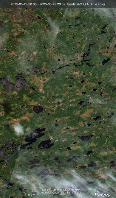
Wildfires in Manitoba continue although the government's priority may have switched to resource extraction projects. See the split map through this link to observe the progression of wildfires around Pimicikamak in Manitoba.

go.nasa.gov/3TUcJ8G
Worldview: Explore Your Dynamic Planet
The NASA Worldview app provides a satellite's perspective of the planet as it looks today and as it has in the past through daily satellite images. Worldview is part of NASA’s Earth Science Data and I...
go.nasa.gov
Reposted by Keshab Thapa
Wildfire recorded on June 12th, 2025 near Cat Lake First Nation, Northwestern Ontario with the satellite image of the area before the wildfire. Source: Copernicus Sentinel 2
A wildfire was recorded on Sentinel 2 near Flin Flon, Canada. More than 300,000 ha of forest burned.
Thanks Dr. Wu 🙏
Your class recordings made the course accessible to students from anywhere in the universe, not only in Tennessee. Thank you for sharing your knowledge with the world. I have been following your videos at my own pace.
No worries. Thank you for the information. See you tomorrow.
Is this workshop today or tomorrow?
It would be great if non-US students could watch the course recordings later!
Please share the link if your talk will be recorded.
Reposted by Keshab Thapa
18F was doing exactly the type of work that DOGE claims to want – yet we were eliminated shortly after midnight. Read our letter to the American people:
18f.org
We're not done yet | 18F
18f.org
Reposted by Keshab Thapa
Today marks the end of #BlackHistoryMonth2025.

As far as I'm concerned, Black History is twenty-four seven, three-hundred sixty five.

Never stop posting our stories and contributions to the world.

Black History is forever. 🌍

#ProudBlue
#ResistanceUnited
#USDemocracy
This is a cool feature!