Richard Heatwave Berler
banner
heatwavekgns.bsky.social
Richard Heatwave Berler
@heatwavekgns.bsky.social
380 followers 510 following 5K posts
I love weather! CBS Duluth, MN May 23, 1976-80, KGNS Laredo, TX Feb 14, 1980-now. NCEI/NWS coop site 415060 June 10, 1985 to December 31, 2023. NWS Jefferson Award. AMS CBM#18
Posts Media Videos Starter Packs
Tuesday 4:10 pm: Melissa is emerging from the north shore of Jamaica. 1st image ~1 hour before landfall, 2nd as it exits land. NHC Key Messages and track forecast:
Tuesday 12:28 pm: Still looks like a near 7 pm arrival of the arrival of the north wind:
Reposted by Richard Heatwave Berler
Update #4: By the metric of observed maximum flight level winds at 700 mb, 10-sec average, preliminary data suggests that #Melissa is now the TOP Atlantic hurricane in the modern era of aircraft reconnaissance (since ~1977).
Tuesday 10:43 am: Melissa’s eye just reaching western Jamaica. NHC shows mile diameter eye. 185 mph winds gusting to 220 mph. Rather compact system wind wise, 75 mph winds confined mainly within 25 miles of center. Much larger geographical scale of flooding rain, storm surge.
Brian’s list of sub 900 mb Atlantic hurricanes…892 mb ties Melissa with 1935 Florida Keys LaborDay hurricane for 3rd lowest pressure.
Tall cloud tower surrounding eye is a prolific lightning producer:
Tuesday 8:38 am: For weather nerds: A 35 minute detailed sampling of Melissa’s eye from 7:36 am CDT to 8:11 am:
Tuesday 8:27 am: Mid/high 90’s, plenty of sun today. Cannot entirely rule out isolated shower as north wind picks up quickly between 6 and 7 pm, gusting 35 mph. 50’s at dawn, low/mid 70’s, sunny, breezy with very dry air Wednesday.
Tuesday 8:05 am: New NHC Update continues to show Hurricane Melissa strengthening with sustained winds of 180 mph, pressure at 896 mb, latest reconnaissance flight measuring as low as 893 mb.
This!
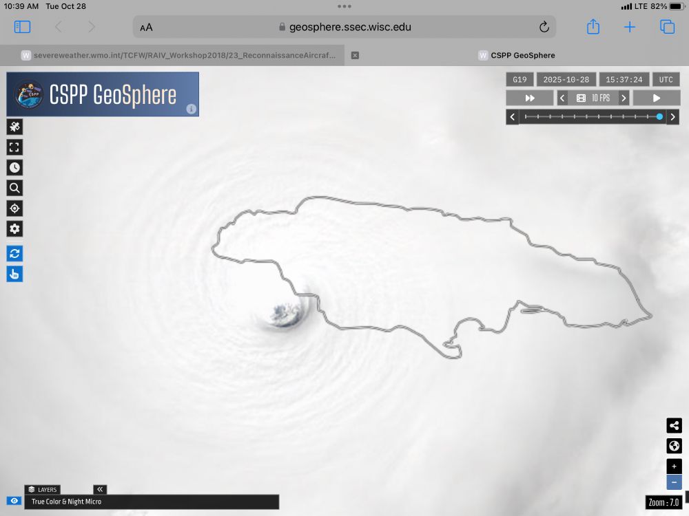
Melissa is a great example of the value of in-situ observations - without recon flights, we largely rely on satellite estimates to assess a storm's current intensity. And current satellite estimates for Melissa are much more intense than what recon has recorded so far.
There's the tie for the record.
I got to watch Koufax pitch at Shea in 1966, Drysdale as well as a 12 year old growing up in Connecticut!
Official advisory showing winds estimated to be gusting to ~215 mph.
Monday 10:17 pm: The key messages from NHC (2nd image) re impact of this storm are sobering, to say the least.
Thanks for this, was wondering about Patricia, Wilma, Gilbert on these methodologies. Amazingly stead state last 24 hours re warm core definition, estimated surface pressure and wind.
Would have made a 4 pm map, but had $165 of groceries stolen from the hatchback of my car at HEB in ~40 seconds while I returned cart to the cart corral. Did not discover until I got home. Here is my 8 pm analysis. Similar heat Tuesday, much cooler Wednesday, 50’s dawn, 70’s pm.
Monday 1:27 pm: Melissa now with sustained 175 mph wind. Rather compact, hurricane force wind (75 mph) extend just 30 miles out from the center. The impact discussion that I am including only speaks to wind, not the exceptional rainfall and storm surge with this storm.
I imagine that dropsondes have helped with estimating surface winds over the one box fits all assumptions based upon winds at flight level, and Dvorak and automated Dvorak estimates. Automated Dvorak has been much higher than what reconnaissance has observed with Melissa.
Reposted by Richard Heatwave Berler
From a crewmember on yesterday's Teal 74 mission into now-Category 5 Hurricane #Melissa. As clear of an eye as you will see in the Atlantic basin.
Reposted by Richard Heatwave Berler
"The NOAA aircraft left the storm early after
experiencing severe turbulence in the southwestern eyewall."

These men and women are not being paid due to the US government shutdown. Not to mention that according to AOML's director emeritus Robert Atlas, they are down 40-50% staff. #Melissa
Monday 9:10 am: Magnitude of pronounced warm core and core of high winds in eyewall are remarkable. 205 mph gust at 700 mb flight level was observed by reconnaissance aircraft.
Monday 8:50 am: A hot airmass will be our weather control through Tuesday afternoon, marginally dry air, high 90’s each day. Much cooler air arrives from Rockies Tuesday night, not enough moisture available for rain.
Reposted by Richard Heatwave Berler
Lightning flashes within the powerful eye wall of Hurricane Melissa.

Incredible imagery this morning of Melissa, a Category 5 storm, south of Jamaica.