Derek Law
@gisbandit.bsky.social
2K followers 210 following 530 posts
Product Manager at Esri | Interests #GIS, #HealthGIS, #Maps, #DataViz
Posts Media Videos Starter Packs
gisbandit.bsky.social
Introducing #ArcGIS #Topographic #Mapping: A unified extension designed for you tinyurl.com/44a8bmf5

#defense #production #maps #series #GIS #esri #cartography #GISchat #geospatial #TheScienceOfWhere #geosky
Reposted by Derek Law

woodwellclimate.bsky.social
4️⃣This shows the presence of ship activity in the Arctic Ocean from 2009-2018. Patterns of blue (low ship numbers) to white (high ship numbers) reflect the human presence in this new, largely becoming ice-free, part of the world.

Data Source: Berkman et al 2020, Esri.
Map by @gfiske.bsky.social
Reposted by Derek Law
civixplorer.bsky.social
🏘️ The most and least expensive land in the contiguous United States.
It highlights high-value areas, such as major urban centers in the Northeast, California, and the Midwest's fertile agricultural zones, where land prices can exceed $500,000 per hectare. In contrast, remote and arid regions in the Southwest and Western plateaus show significantly lower values, often under $5,000 per hectare. 

The map illustrates how factors like population density, economic activity, and local policies shape land values, while public lands and Native American reservations are excluded from the private market valuation.
gisbandit.bsky.social
#ArcGIS Field #Maps: Introducing Tasks tinyurl.com/585s6phx

#FieldOperations #WorkOrders #mobile #GIS #AssetManagement #esri #mapping #GISchat #geospatial #TheScienceOfWhere #geosky
Reposted by Derek Law
geographers.bsky.social
Are you ready? #GeoWeek2025 takes place November 17-21! It’s not too early to get involved. Here’s how you can take action:
🌎 Become a GeoAdvocate.
🌟 Be a Promotional Partner.
📆 Help Us Publicize Your Events.
🌱 Get Classroom Resources from AAG.

Learn more: buff.ly/oukmzeD #EduSKy #GeoSky
Graphic promoting the 2025 Geography Awareness Week theme with earth from the atmosphere.
Reposted by Derek Law
civixplorer.bsky.social
Roads of the Roman Empire.

🔎 researchremora
Reposted by Derek Law
civixplorer.bsky.social
🛢️ U.S. oil production by state.

🔎 Elements
gisbandit.bsky.social
Nice #Urban Centre Explorer #dashboard by City of Kelowna built w/ #ArcGISDashboards tinyurl.com/3c6e2dfx

#Kelowna #BC #dataviz #govtech #municipal #community #GIS #esri #esriCanada #arcgis #ArcGISApps #GISchat #geospatial #TheScienceOfWhere #geosky
Reposted by Derek Law
hydrology.nl
It looks like British Columbia is nice as well.
Reposted by Derek Law
civixplorer.bsky.social
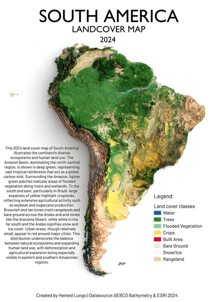
🌳 South America landcover map.
Reposted by Derek Law
civixplorer.bsky.social
The Roman Empire, by National Geographic Society.
Reposted by Derek Law
southarrowmaps.co.nz
This animation shows the difference between rotating the orthographic camera (first half) which produces foreshortening, and adjusting the Y-value of the input normal to the displacement node (second half).
gisbandit.bsky.social
#Esridevs, please complete the #Esri #Developer #AI survey tinyurl.com/yv4b7pp3

#geodev #GIS #arcgis #GISchat #geospatial #SDK #mapping #TheScienceOfWhere #geosky
Reposted by Derek Law
ignfrance.bsky.social
Avancement du programme #LiDARHD

✔️​ 93 % de la couverture finale volée > 512 000 km2 (acquisition des données)
✔️​ 466 865 km2 de nuages de points diffusés > 84 % de la couverture finale
✔️​ 419 561 km2 de MNx diffusés > 75 % de la couverture finale

La Région Normandie rejoint le programme 🤝
Reposted by Derek Law
brilliantmaps.bsky.social
Host cities for the 2026 FIFA World Cup

credit: cbssportsgolazo
Reposted by Derek Law
deepseadawn.bsky.social
Did you know that you can now bring Google Earth Engine data right into ArcGIS Pro?

Here’s a new storymap with details and a link to the tool on @github.com and thoughts on a possible interoperability of GEE and ArcGIS Pro.

storymaps.arcgis.com/stories/bf22...
#gischat #geogchat #geogsky ⚒️ 🌎 🌍 🌏
Bring Google Earth Engine’s Data Right into ArcGIS Pro
Access Google Earth Engine's Data Catalog in ArcGIS Pro
storymaps.arcgis.com
Reposted by Derek Law
rauljimenez.info
Developers, UX designers, and the rest of the crew... 𝐭𝐡𝐢𝐬 𝐨𝐧𝐞’𝐬 𝐟𝐨𝐫 𝐲𝐨𝐮! 👀

If this doesn’t show what makes feature services + ArcGIS Maps SDKs special ... well, I give up 😂: www.esri.com/arcgis-blog/...

This article is part of a 📚 blog series I’m writing: lnkd.in/euvBHXqH 🦄 🤣
Reposted by Derek Law
edyhsgr.mastodon.social.ap.brid.gy
'USA Structures Data' (ArcGIS feature layer utilizing Federal Emergency Management Agency data) - U.S. Federal Datasets Shared by Esri
https://fedmaps.maps.arcgis.com/home/item.html?id=0ec8512ad21e4bb987d7e848d14e7e24
#gis #demography #popmastodon
ArcGIS
fedmaps.maps.arcgis.com
Reposted by Derek Law
pablohernandezb.bsky.social
📢 New Map Alert! Just finished this detailed 3D hydrologic map of Venezuela🇻🇪. See the country's rivers like never before!

It's time for another #1Week1Project📅💻, find out how you can make your own gorgeous map too!

Let's open a 🧵👇🏽

#HydrologicMap💧🗺
#DataArt🎨📊
Reposted by Derek Law
archive.pants.place
Author: carly.aprx Handle: carly.aprx

honestly never a doubt. shoutout esri💙✨ #GIS #maps #gulfofmexico #esri #meme #tiktok #archive
gisbandit.bsky.social
In 2 weeks, join #Esri's free #MOOC to explore modern approaches to visualize, process, and maximize insights from #imagery & #RemoteSensing #data tinyurl.com/28fzh7un

#images #sensors #GIS #arcgis #mapping #GISchat #geospatial #geography #EsriTraining #TheScienceOfWhere #geosky
Reposted by Derek Law
transitdiagrams.bsky.social
🚆 Carinthia’s public transport network is getting a redesign for 2025 due to the opening auf the Koralmbahn rail tunnel.
I designed the new official network map for Verkehrsverbund Kärnten.

👉 www.kaerntner-linien.at/news/koralmb...

#Koralmbahn #Carinthia #Kärnten #PublicTransport #TransitDiagrams
transit map Kärnten as of Dec 2025