
➡️ Airborne Laser Scanning (ALS) is operational for forest inventory in Canada enabling EFIs.
➡️ Coverage exceeds 66% of Canada’s managed forest area (~230 million ha). #lidar
🔗 doi.org/10.1139/cjfr...

Reposted by Michael A. Wulder
Check out the line up of workshops, speakers, field tour & social events! 👉 www.silvilaser2025.com/program
Which plenary session are you most looking forward to?!
Registration for extra activities closes Sep 10
📍 Quebec City Convention Centre
Reposted by Michael A. Wulder

dx.doi.org/10.1109/LGRS...
📖: Geoscience and Remote Sensing Letters
✍️: Ye, Coops, Hermosilla @txominhermos.bsky.social, Wulder @mikewulder.bsky.social, Gergel
#Segmentation #ChangeDetection #Landsat #ubcforestry

Research themes:
-Vegetation Resilience in Boreal Ecosystems
-Satellite Data and Model Integration
-Climate Change Impacts
-Early Warning Indicators
➡️https://www.researchgate.net/profile/Ramon-Melser

Reposted by Michael A. Wulder
He joins the wall after successfully defending his thesis: “Enhanced assessment of boreal vegetation productivity using integrated satellite-derived datasets and analysis approaches.”
#IRSSLab #UBCForestry
Reposted by Michael A. Wulder
Yrttimaa et al. Quantifying architectural uniqueness of Scots pine trees using terrestrial laser scanning: toward individual tree fingerprinting. #lidar #tls
academic.oup.com/forestry/art...
academic.oup.com/forestry/art...
Check out the link below for collection of High-Impact Research from Forestry 👇👇
Reposted by Michael A. Wulder
This week away gave lab members the chance to share research updates, pick up new skills from colleagues and guests, and, of course, enjoy some much-needed R&R!
#UBCForestry #remotesensing


Reposted by Michael A. Wulder
Reposted by Michael A. Wulder, Matthias Cuntz
“Retrieving yearly forest growth from satellite data: A deep learning based approach.”
📖 Published in Remote Sensing of Environment:
www.sciencedirect.com/science/arti...
1/4

Paper: doi.org/10.1093/fore...
Download data opendata.nfis.org/mapserver/nf...
Data on #GEE: gee-community-catalog.org/projects/ca_...
Reposted by Michael A. Wulder

📝 doi.org/10.7717/peer...
🖥️ stac.openlandmap.org/gpw_ugpp.dai...

by Mike Flannigan — Reposted by Michael A. Wulder, Stephen D. Murphy, Mike Flannigan
thetradeoff.substack.com/p/north-amer...

Insight from Prof Trisalyn Nelson, Jack & Laura Dangermond Chair of Geography, UCSB.
www.independent.com/2025/08/20/g...

Reposted by Michael A. Wulder
Diószegi et al. develop a workflow that automates and optimises CBH detection in already segmented individual trees.
🗞️ doi.org/10.1093/fore...
🔧 github.com/DijoG/treecbh

Reposted by Michael A. Wulder
Reposted by Michael A. Wulder
Reposted by Michael A. Wulder
Reposted by Michael A. Wulder

Reposted by Michael A. Wulder
Reposted by Michael A. Wulder
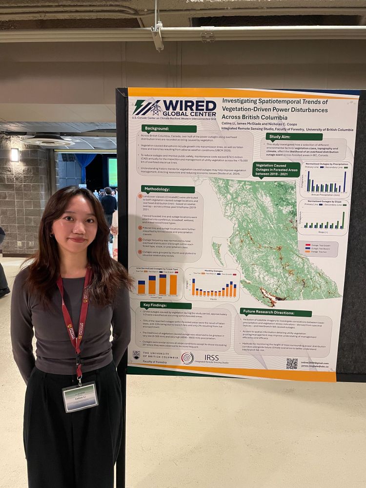
Wonderful work from James (@jamesmcglade.bsky.social), Eliceo and Celine!
#IRSSlab #ubcforestry


Reposted by Michael A. Wulder

Thanks to all who demo’d the Outdoors Tips & Tricks!🔨
@la-stack.bsky.social with the #Trimble, @jamesmcglade.bsky.social with the the #GeoSlam & Liam with PostEx👏
@irssubc.bsky.social @forestry.ubc.ca @metafor-ulaval.bsky.social


Are you asking "how much" or "if" climate change has impacted your system, then this paper is for you!
🧪🌏🌐🍁🌺🌱🌿
onlinelibrary.wiley.com/doi/10.1111/...
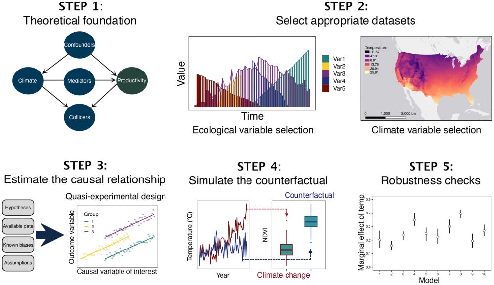

📜 doi.org/10.1111/nph....

Reposted by Michael A. Wulder
We have a call for papers for a new Special Issue with
@silvilaser2025.bsky.social
SilviLaser 2025: Laser scanning applications in forest management
⏰ Submission deadline: 30th November 2025
More information here👇
academic.oup.com/forestry/pag...
