


An updated version of the EPS-SG SCAtterometer (SCA) L1b test data (version 3) has been released to users bit.ly/47Oy6jT

November 13, 2025 at 3:38 PM
An updated version of the EPS-SG SCAtterometer (SCA) L1b test data (version 3) has been released to users bit.ly/47Oy6jT
Special Weather Statement issued November 4 at 6:00PM ChST by NWS Tiyan GU
Additional Details Here.
Additional Details Here.


November 4, 2025 at 8:15 AM
Special Weather Statement issued November 4 at 6:00PM ChST by NWS Tiyan GU
Additional Details Here.
Additional Details Here.
Special Weather Statement issued November 4 at 5:36AM ChST by NWS Tiyan GU
Additional Details Here.
Additional Details Here.

November 3, 2025 at 7:45 PM
Special Weather Statement issued November 4 at 5:36AM ChST by NWS Tiyan GU
Additional Details Here.
Additional Details Here.
Special Weather Statement issued November 3 at 3:03PM ChST by NWS Tiyan GU
Additional Details Here.
Additional Details Here.

November 3, 2025 at 5:15 AM
Special Weather Statement issued November 3 at 3:03PM ChST by NWS Tiyan GU
Additional Details Here.
Additional Details Here.

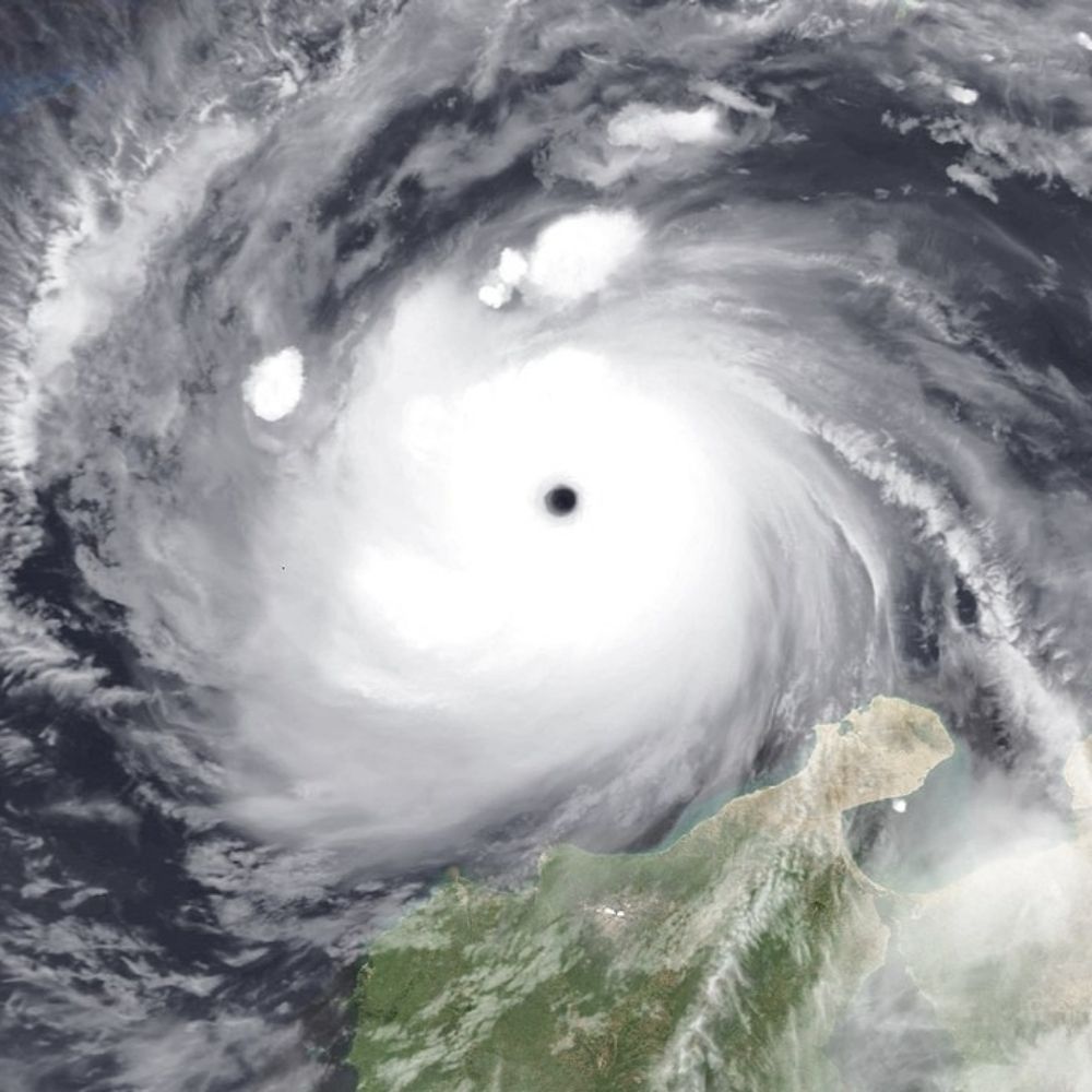
The scatterometer data we use to retrieve wind allow measuring the wind speed and direction over open ocean. Due to land contamination of the data, we however remove the biased information in coastal areas. That is why our measurement miss here the centre of the hurricane.
October 29, 2025 at 3:14 PM
The scatterometer data we use to retrieve wind allow measuring the wind speed and direction over open ocean. Due to land contamination of the data, we however remove the biased information in coastal areas. That is why our measurement miss here the centre of the hurricane.

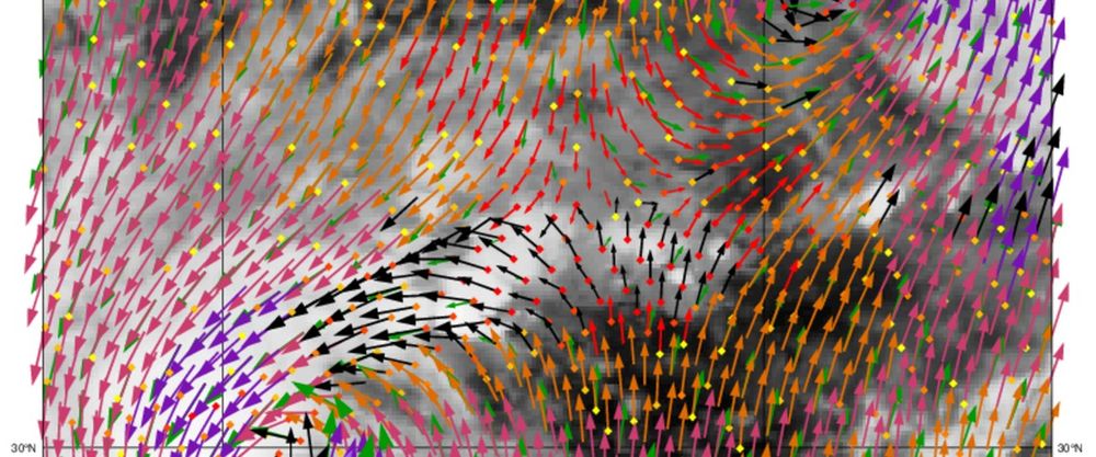
Vanochtend vroeg werden de tropische orkanen Humberto en Imelda gelijktijdig vastgelegd door de Chinese HY2-C wind scatterometer. Het KNMI leverde de windsnelheden en-richtingen van de wind boven zee die bij beide orkanen horen.
Humberto en Imelda samen gespot
Vanochtend vroeg werden de tropische orkanen Humberto en Imelda gelijktijdig vastgelegd door de Chinese HY2-C wind scatterometer. Het KNMI leverde de windsnelheden en-richtingen van de wind boven zee
www.knmi.nl
October 1, 2025 at 10:30 AM
Vanochtend vroeg werden de tropische orkanen Humberto en Imelda gelijktijdig vastgelegd door de Chinese HY2-C wind scatterometer. Het KNMI leverde de windsnelheden en-richtingen van de wind boven zee die bij beide orkanen horen.

Vanochtend vroeg werden de tropische orkanen Humberto en Imelda gelijktijdig vastgelegd door de Chinese HY2-C wind scatterometer. Het KNMI leverde de windsnelheden en-richtingen van de wind boven zee die bij beide orkanen horen.

Humberto en Imelda samen gespot
Vanochtend vroeg werden de tropische orkanen Humberto en Imelda gelijktijdig vastgelegd door de Chinese HY2-C wind scatterometer. Het KNMI leverde de windsnelheden en-richtingen van de wind boven zee
www.knmi.nl
October 1, 2025 at 10:30 AM
Vanochtend vroeg werden de tropische orkanen Humberto en Imelda gelijktijdig vastgelegd door de Chinese HY2-C wind scatterometer. Het KNMI leverde de windsnelheden en-richtingen van de wind boven zee die bij beide orkanen horen.
NWS National Hurricane Center Miami FL
1100 AM PDT Mon Sep 29 2025
For the eastern and central North Pacific east of 180 longitude:
1100 AM PDT Mon Sep 29 2025
For the eastern and central North Pacific east of 180 longitude:


September 29, 2025 at 10:54 PM
NWS National Hurricane Center Miami FL
1100 AM PDT Mon Sep 29 2025
For the eastern and central North Pacific east of 180 longitude:
1100 AM PDT Mon Sep 29 2025
For the eastern and central North Pacific east of 180 longitude:
NHC Eastern North Pacific Outlook update for Mon, 29 Sep 2025 17:49:44 UTC
Additional Details Here.
Additional Details Here.


September 29, 2025 at 6:00 PM
NHC Eastern North Pacific Outlook update for Mon, 29 Sep 2025 17:49:44 UTC
Additional Details Here.
Additional Details Here.

Scatterometer is used in ERA5. See table 4: rmets.onlinelibrary.wiley.com/doi/abs/10.1...
Contrast with ERA5-land, which assimilated no data.
Contrast with ERA5-land, which assimilated no data.

The ERA5 global reanalysis
This paper presents a comprehensive overview of the ERA5 global reanalysis from 1979 onwards, which is produced at ECMWF as part of the Copernicus Climate Change Service. It provides a detailed...
rmets.onlinelibrary.wiley.com
September 24, 2025 at 2:38 PM
Scatterometer is used in ERA5. See table 4: rmets.onlinelibrary.wiley.com/doi/abs/10.1...
Contrast with ERA5-land, which assimilated no data.
Contrast with ERA5-land, which assimilated no data.
Special Weather Statement issued September 21 at 5:42PM ChST by NWS Tiyan GU
Additional Details Here.
Additional Details Here.

September 21, 2025 at 7:45 AM
Special Weather Statement issued September 21 at 5:42PM ChST by NWS Tiyan GU
Additional Details Here.
Additional Details Here.
Of course the opposite side is currently obscured by deep convection but advanced scatterometer data from this afternoon shows us that stronger winds are in the north(west) and this is consistent with modelling and typical storm evolution in these parts.


September 10, 2025 at 10:05 PM
Of course the opposite side is currently obscured by deep convection but advanced scatterometer data from this afternoon shows us that stronger winds are in the north(west) and this is consistent with modelling and typical storm evolution in these parts.
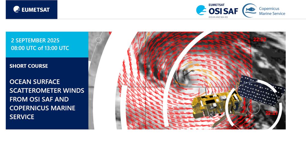
If you missed our webinar on #Ocean Surface #Scatterometer #Winds products 🌬️🛰️, or want to see it again, you can now access a recorded version on our youtube!
youtu.be/-tTiskP0seU
@copernicusmarine.bsky.social @knmi.nl @hayleyeversking.bsky.social @gwenbras.bsky.social
youtu.be/-tTiskP0seU
@copernicusmarine.bsky.social @knmi.nl @hayleyeversking.bsky.social @gwenbras.bsky.social

Webinar: Ocean Surface Scatterometer Winds from OSI SAF and Copenicus Marine Service (02/09/2025)
YouTube video by OSI SAF
youtu.be
September 5, 2025 at 1:12 PM
If you missed our webinar on #Ocean Surface #Scatterometer #Winds products 🌬️🛰️, or want to see it again, you can now access a recorded version on our youtube!
youtu.be/-tTiskP0seU
@copernicusmarine.bsky.social @knmi.nl @hayleyeversking.bsky.social @gwenbras.bsky.social
youtu.be/-tTiskP0seU
@copernicusmarine.bsky.social @knmi.nl @hayleyeversking.bsky.social @gwenbras.bsky.social
Last day to register to our #scatterometer #wind webinar!
Next week, on Tuesday 02/09/2025, our #ocean #wind #scatterometer retrieval team at @knmi.nl will explain all you need to know about these products 🌬️🛰️ from the catalogue of @osi-saf.eumetsat.int
and @copernicusmarine.bsky.social .
Don't forget to register on: eumetsat.zoom.us/webinar/regi...
and @copernicusmarine.bsky.social .
Don't forget to register on: eumetsat.zoom.us/webinar/regi...
September 1, 2025 at 11:51 AM
Last day to register to our #scatterometer #wind webinar!
Next week, on Tuesday 02/09/2025, our #ocean #wind #scatterometer retrieval team at @knmi.nl will explain all you need to know about these products 🌬️🛰️ from the catalogue of @osi-saf.eumetsat.int
and @copernicusmarine.bsky.social .
Don't forget to register on: eumetsat.zoom.us/webinar/regi...
and @copernicusmarine.bsky.social .
Don't forget to register on: eumetsat.zoom.us/webinar/regi...
August 26, 2025 at 8:35 AM
Next week, on Tuesday 02/09/2025, our #ocean #wind #scatterometer retrieval team at @knmi.nl will explain all you need to know about these products 🌬️🛰️ from the catalogue of @osi-saf.eumetsat.int
and @copernicusmarine.bsky.social .
Don't forget to register on: eumetsat.zoom.us/webinar/regi...
and @copernicusmarine.bsky.social .
Don't forget to register on: eumetsat.zoom.us/webinar/regi...
On Tuesday 02/09/2025, our #ocean #wind #scatterometer retrieval team at @knmi.nl will explain all you need to know about these satellite products 🌬️🛰️ from the catalogue of @osi-saf.eumetsat.int and @copernicusmarine.bsky.social.
Register now to this free seminar: eumetsat.zoom.us/webinar/regi...
Register now to this free seminar: eumetsat.zoom.us/webinar/regi...

August 14, 2025 at 7:26 AM
On Tuesday 02/09/2025, our #ocean #wind #scatterometer retrieval team at @knmi.nl will explain all you need to know about these satellite products 🌬️🛰️ from the catalogue of @osi-saf.eumetsat.int and @copernicusmarine.bsky.social.
Register now to this free seminar: eumetsat.zoom.us/webinar/regi...
Register now to this free seminar: eumetsat.zoom.us/webinar/regi...

Congrats to the ESA for launching the 1st part of the Second Generation MetOp mission!
I for one am very excited about Metop-SG B1 follow on that is planning launch in January 2026 since it includes another C-band scatterometer.
space.oscar.wmo.int/instruments/...
I for one am very excited about Metop-SG B1 follow on that is planning launch in January 2026 since it includes another C-band scatterometer.
space.oscar.wmo.int/instruments/...
August 13, 2025 at 2:44 PM
Congrats to the ESA for launching the 1st part of the Second Generation MetOp mission!
I for one am very excited about Metop-SG B1 follow on that is planning launch in January 2026 since it includes another C-band scatterometer.
space.oscar.wmo.int/instruments/...
I for one am very excited about Metop-SG B1 follow on that is planning launch in January 2026 since it includes another C-band scatterometer.
space.oscar.wmo.int/instruments/...
Are you using #scatterometer retrieval of #ocean #wind from @osi-saf.eumetsat.int or @copernicusmarine.bsky.social, or planning to?
On Tuesday 02/09/2025, our @knmi.nl specialists will answer all your questions about these satellite products 🌬️🛰️
register on: eumetsat.zoom.us/webinar/regi...
On Tuesday 02/09/2025, our @knmi.nl specialists will answer all your questions about these satellite products 🌬️🛰️
register on: eumetsat.zoom.us/webinar/regi...
July 17, 2025 at 9:56 AM
Are you using #scatterometer retrieval of #ocean #wind from @osi-saf.eumetsat.int or @copernicusmarine.bsky.social, or planning to?
On Tuesday 02/09/2025, our @knmi.nl specialists will answer all your questions about these satellite products 🌬️🛰️
register on: eumetsat.zoom.us/webinar/regi...
On Tuesday 02/09/2025, our @knmi.nl specialists will answer all your questions about these satellite products 🌬️🛰️
register on: eumetsat.zoom.us/webinar/regi...

Our proposal for Earth Explorer 11 was "STREAM" using a Doppler scatterometer and estimated to be too expensive. I then helped a little with SEASTAR (using a better measuring technique with ATI SAR, but a much narrower swath).. and now there is a little hope that WIVERN can deliver some currents.
July 9, 2025 at 8:19 AM
Our proposal for Earth Explorer 11 was "STREAM" using a Doppler scatterometer and estimated to be too expensive. I then helped a little with SEASTAR (using a better measuring technique with ATI SAR, but a much narrower swath).. and now there is a little hope that WIVERN can deliver some currents.
The Advanced Scatterometer (ASCAT) Data Products manati.star.nesdis.noaa.gov/datasets/ASC...
This is the amazing tool that predicts and tracks hurricanes and other storms. The Trump administration has decided that in a month, this data will only be available to the military.
This is the amazing tool that predicts and tracks hurricanes and other storms. The Trump administration has decided that in a month, this data will only be available to the military.
The Advanced Scatterometer (ASCAT) Data Products
manati.star.nesdis.noaa.gov
July 2, 2025 at 4:35 AM
The Advanced Scatterometer (ASCAT) Data Products manati.star.nesdis.noaa.gov/datasets/ASC...
This is the amazing tool that predicts and tracks hurricanes and other storms. The Trump administration has decided that in a month, this data will only be available to the military.
This is the amazing tool that predicts and tracks hurricanes and other storms. The Trump administration has decided that in a month, this data will only be available to the military.

An
earlier scatterometer pass around 1629 UTC showed a peak wind of 47
kt, and helped to refine the current tropical-storm-force wind
radii. Latest objective and subjective satellite intensity estimates
range from 45 to 55 kt, including a T/3.5 from TAFB.
earlier scatterometer pass around 1629 UTC showed a peak wind of 47
kt, and helped to refine the current tropical-storm-force wind
radii. Latest objective and subjective satellite intensity estimates
range from 45 to 55 kt, including a T/3.5 from TAFB.
June 30, 2025 at 9:35 PM
An
earlier scatterometer pass around 1629 UTC showed a peak wind of 47
kt, and helped to refine the current tropical-storm-force wind
radii. Latest objective and subjective satellite intensity estimates
range from 45 to 55 kt, including a T/3.5 from TAFB.
earlier scatterometer pass around 1629 UTC showed a peak wind of 47
kt, and helped to refine the current tropical-storm-force wind
radii. Latest objective and subjective satellite intensity estimates
range from 45 to 55 kt, including a T/3.5 from TAFB.
This wind field matches the satellite-derived scatterometer wind
data at 1619 UTC which showed a closed circulation, but with peak
winds of only 24 kt.
data at 1619 UTC which showed a closed circulation, but with peak
winds of only 24 kt.
June 28, 2025 at 11:12 PM
This wind field matches the satellite-derived scatterometer wind
data at 1619 UTC which showed a closed circulation, but with peak
winds of only 24 kt.
data at 1619 UTC which showed a closed circulation, but with peak
winds of only 24 kt.

Shallow convection and weak circulation but fishy enough. Quick assist from the subtropics while the tropical Atlantic sleeps? I've seen worse. NHC says 20% for now. Narrow window and no threat to land regardless.


June 22, 2025 at 8:02 PM
Shallow convection and weak circulation but fishy enough. Quick assist from the subtropics while the tropical Atlantic sleeps? I've seen worse. NHC says 20% for now. Narrow window and no threat to land regardless.

Universitat Hamburg is hiring:
Research Associate for the DFG Project “MultiSCOSS” concerned with scatterometer sea-ice studies
Research Associate for the DFG Project “MultiSCOSS” concerned with scatterometer sea-ice studies
May 30, 2025 at 5:06 AM
Universitat Hamburg is hiring:
Research Associate for the DFG Project “MultiSCOSS” concerned with scatterometer sea-ice studies
Research Associate for the DFG Project “MultiSCOSS” concerned with scatterometer sea-ice studies

#Radartechnologie gilt als aktives Fernerkundungssystem, da sie aktiv einen #Mikrowellenimpuls sendet und die reflektierte Energie erfasst. Dopplerradar, Scatterometer und Radarhöhenmesser sind Beispiele für aktive Fernerkundungsinstrumente, die Mikrowellenfrequenzen nutzen...

Microwaves - NASA Science
You may be familiar with microwave images as they are used on TV weather news and you can even use microwaves to cook your food. Microwave ovens work by using
science-nasa-gov.translate.goog
May 18, 2025 at 4:07 PM
#Radartechnologie gilt als aktives Fernerkundungssystem, da sie aktiv einen #Mikrowellenimpuls sendet und die reflektierte Energie erfasst. Dopplerradar, Scatterometer und Radarhöhenmesser sind Beispiele für aktive Fernerkundungsinstrumente, die Mikrowellenfrequenzen nutzen...