


🚀 GeoAI v0.16.0 is here!
Train image segmentation models and instantly visualize performance metrics with a single line of Python code. 💡
📦 GitHub: github.com/opengeos/geoai
📓 Example notebook: opengeoai.org/examples/tra...
#GeoAI #DeepLearning #GeospatialAI #Python #OpenSource #RemoteSensing
Train image segmentation models and instantly visualize performance metrics with a single line of Python code. 💡
📦 GitHub: github.com/opengeos/geoai
📓 Example notebook: opengeoai.org/examples/tra...
#GeoAI #DeepLearning #GeospatialAI #Python #OpenSource #RemoteSensing

October 16, 2025 at 10:06 PM
🚀 GeoAI v0.16.0 is here!
Train image segmentation models and instantly visualize performance metrics with a single line of Python code. 💡
📦 GitHub: github.com/opengeos/geoai
📓 Example notebook: opengeoai.org/examples/tra...
#GeoAI #DeepLearning #GeospatialAI #Python #OpenSource #RemoteSensing
Train image segmentation models and instantly visualize performance metrics with a single line of Python code. 💡
📦 GitHub: github.com/opengeos/geoai
📓 Example notebook: opengeoai.org/examples/tra...
#GeoAI #DeepLearning #GeospatialAI #Python #OpenSource #RemoteSensing

Curious about AI's role in geospatial work? Check out Eyes on Earth Episode 131 to learn how it's revolutionizing the field! #GeospatialAI
https://www.youtube.com/watch?v=2CWzUntJdOo
https://www.youtube.com/watch?v=2CWzUntJdOo
- YouTube
Enjoy the videos and music you love, upload original content, and share it all with friends, family, and the world on YouTube.
www.youtube.com
March 3, 2025 at 9:52 PM
Curious about AI's role in geospatial work? Check out Eyes on Earth Episode 131 to learn how it's revolutionizing the field! #GeospatialAI
https://www.youtube.com/watch?v=2CWzUntJdOo
https://www.youtube.com/watch?v=2CWzUntJdOo

🚀 Exciting News! Lander Analytics is proud to partner with Kinetica, a leader in GPU-accelerated analytics, to drive geospatial AI & large-scale ML innovation. Together, we're pushing real-time insights to the next level!
Read more: bit.ly/PRKLA
#GeospatialAI #ML #AI
Read more: bit.ly/PRKLA
#GeospatialAI #ML #AI
Kinetica and Lander Analytics Partner to Drive Next-Generation Geospatial AI and Data Science Innovation
Arlington, VA & New York, NY – [March 24th, 2025] – Kinetica, the real-time database for generative retrieval and analytics, today announced a strategic partnership with Lander Analytics, a leading da...
bit.ly
March 25, 2025 at 4:11 PM
🚀 Exciting News! Lander Analytics is proud to partner with Kinetica, a leader in GPU-accelerated analytics, to drive geospatial AI & large-scale ML innovation. Together, we're pushing real-time insights to the next level!
Read more: bit.ly/PRKLA
#GeospatialAI #ML #AI
Read more: bit.ly/PRKLA
#GeospatialAI #ML #AI

Microsoft's Planetary Computer Pro is unlocking AI-powered geospatial insights for enterprises, enhancing decision-making and offering scalable solutions to complex global challenges. #GeospatialAI #AzureInnovations

Microsoft Planetary Computer Pro: Unlocking AI-powered geospatial insights for enterprises across industries | Microsoft Azure Blog
We are excited to introduce the Public Preview of Microsoft Planetary Computer Pro, a comprehensive platform that makes it dramatically easier for organizations to harness geospatial data for real-world impact. Learn more.
azure.microsoft.com
July 6, 2025 at 6:15 PM
Microsoft's Planetary Computer Pro is unlocking AI-powered geospatial insights for enterprises, enhancing decision-making and offering scalable solutions to complex global challenges. #GeospatialAI #AzureInnovations

🌍 Voices of Sentinel at #LPS2025
Aravind Ravichandran, founder of #TerraWatchSpace, shares his reflections on a standout theme at this year’s symposium: the growing role of Sentinel data in powering #FoundationModels.
#VoicesOfSentinel #EarthObservation #Copernicus #SentinelData #GeospatialAI
Aravind Ravichandran, founder of #TerraWatchSpace, shares his reflections on a standout theme at this year’s symposium: the growing role of Sentinel data in powering #FoundationModels.
#VoicesOfSentinel #EarthObservation #Copernicus #SentinelData #GeospatialAI
September 10, 2025 at 9:40 AM
🌍 Voices of Sentinel at #LPS2025
Aravind Ravichandran, founder of #TerraWatchSpace, shares his reflections on a standout theme at this year’s symposium: the growing role of Sentinel data in powering #FoundationModels.
#VoicesOfSentinel #EarthObservation #Copernicus #SentinelData #GeospatialAI
Aravind Ravichandran, founder of #TerraWatchSpace, shares his reflections on a standout theme at this year’s symposium: the growing role of Sentinel data in powering #FoundationModels.
#VoicesOfSentinel #EarthObservation #Copernicus #SentinelData #GeospatialAI

🌍 AI + GIS = Smarter Business Strategies
Geospatial AI is transforming industries with predictive analytics, risk assessment, and spatial intelligence.
Are you ready for what’s next? Read more: quarticle.ro/blog/geospat...
#GeospatialAI #MachineLearning #GIS #AI #PredictiveAnalytics
Geospatial AI is transforming industries with predictive analytics, risk assessment, and spatial intelligence.
Are you ready for what’s next? Read more: quarticle.ro/blog/geospat...
#GeospatialAI #MachineLearning #GIS #AI #PredictiveAnalytics

February 13, 2025 at 8:22 AM
🌍 AI + GIS = Smarter Business Strategies
Geospatial AI is transforming industries with predictive analytics, risk assessment, and spatial intelligence.
Are you ready for what’s next? Read more: quarticle.ro/blog/geospat...
#GeospatialAI #MachineLearning #GIS #AI #PredictiveAnalytics
Geospatial AI is transforming industries with predictive analytics, risk assessment, and spatial intelligence.
Are you ready for what’s next? Read more: quarticle.ro/blog/geospat...
#GeospatialAI #MachineLearning #GIS #AI #PredictiveAnalytics

#AINews 🌍 DragOSM revolutionizes urban analysis with AI framework that enhances building extraction precision from aerial images. A game-changer for smart cities! #GeospatialAI #SmarterWithAI

September 29, 2025 at 7:17 PM
#AINews 🌍 DragOSM revolutionizes urban analysis with AI framework that enhances building extraction precision from aerial images. A game-changer for smart cities! #GeospatialAI #SmarterWithAI

Bay Area Teen Showcases Deepfake Detection Research At Conference
Full Story: indiawest.com/bay-area-tee...
#VaishnavAnand #DeepfakeDetection #AIResearch #CybersecurityAwareness #SatelliteSecurity #GeospatialAI #MITURTC #IEEEConference #DanvilleInnovator #AthenianSchool #TeenScientist
Full Story: indiawest.com/bay-area-tee...
#VaishnavAnand #DeepfakeDetection #AIResearch #CybersecurityAwareness #SatelliteSecurity #GeospatialAI #MITURTC #IEEEConference #DanvilleInnovator #AthenianSchool #TeenScientist
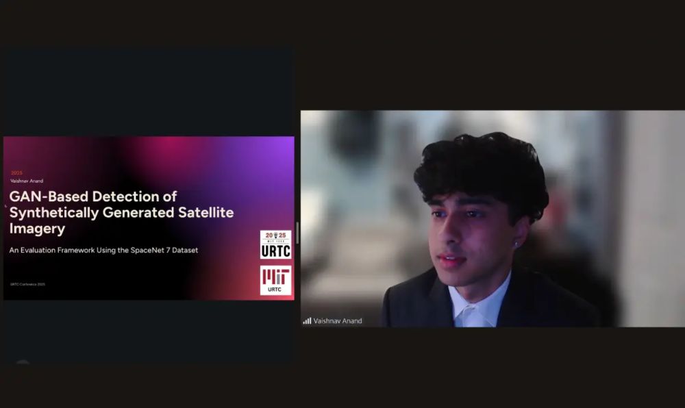
Bay Area Teen Showcases Deepfake Detection Research At Conference - IndiaWest News
Bay Area Teen Showcases Deepfake Detection Research At Conference.
indiawest.com
October 18, 2025 at 11:52 AM
Bay Area Teen Showcases Deepfake Detection Research At Conference
Full Story: indiawest.com/bay-area-tee...
#VaishnavAnand #DeepfakeDetection #AIResearch #CybersecurityAwareness #SatelliteSecurity #GeospatialAI #MITURTC #IEEEConference #DanvilleInnovator #AthenianSchool #TeenScientist
Full Story: indiawest.com/bay-area-tee...
#VaishnavAnand #DeepfakeDetection #AIResearch #CybersecurityAwareness #SatelliteSecurity #GeospatialAI #MITURTC #IEEEConference #DanvilleInnovator #AthenianSchool #TeenScientist

🚀 Just published! Our method uses aerial imagery, POIs & ML (LightGBM, GBDT) to classify building uses & estimate heights in data-limited areas. Scalable for global urban planning! 🌍 Read more: www.mdpi.com/2072-4292/16...
#UrbanPlanning #AI #GeospatialAI
#UrbanPlanning #AI #GeospatialAI

Open Data-Driven 3D Building Models for Micro-Population Mapping in a Data-Limited Setting
Urban planning and management increasingly depend on accurate building and population data. However, many regions lack sufficient resources to acquire and maintain these data, creating challenges in d...
www.mdpi.com
November 30, 2024 at 11:12 PM
🚀 Just published! Our method uses aerial imagery, POIs & ML (LightGBM, GBDT) to classify building uses & estimate heights in data-limited areas. Scalable for global urban planning! 🌍 Read more: www.mdpi.com/2072-4292/16...
#UrbanPlanning #AI #GeospatialAI
#UrbanPlanning #AI #GeospatialAI
Date: Friday, 7th November 2025
Time: 4:00 PM (WAT)
Venue: DSN General Telegram Community
In this session, you’ll learn the core principles of satellite image processing and how to extract meaningful environmental insights using Python.
#datasciencenigeria #GeospatialAI #GIS
Time: 4:00 PM (WAT)
Venue: DSN General Telegram Community
In this session, you’ll learn the core principles of satellite image processing and how to extract meaningful environmental insights using Python.
#datasciencenigeria #GeospatialAI #GIS
November 5, 2025 at 9:37 AM
Date: Friday, 7th November 2025
Time: 4:00 PM (WAT)
Venue: DSN General Telegram Community
In this session, you’ll learn the core principles of satellite image processing and how to extract meaningful environmental insights using Python.
#datasciencenigeria #GeospatialAI #GIS
Time: 4:00 PM (WAT)
Venue: DSN General Telegram Community
In this session, you’ll learn the core principles of satellite image processing and how to extract meaningful environmental insights using Python.
#datasciencenigeria #GeospatialAI #GIS

Exciting times ahead—welcome, Omar! 🚀
hashtag#WelcomeToTheTeam hashtag#GeospatialAI hashtag#RiskAssessment hashtag#MachineLearning hashtag#DurhamUniversity
hashtag#WelcomeToTheTeam hashtag#GeospatialAI hashtag#RiskAssessment hashtag#MachineLearning hashtag#DurhamUniversity
March 12, 2025 at 9:15 AM
Exciting times ahead—welcome, Omar! 🚀
hashtag#WelcomeToTheTeam hashtag#GeospatialAI hashtag#RiskAssessment hashtag#MachineLearning hashtag#DurhamUniversity
hashtag#WelcomeToTheTeam hashtag#GeospatialAI hashtag#RiskAssessment hashtag#MachineLearning hashtag#DurhamUniversity

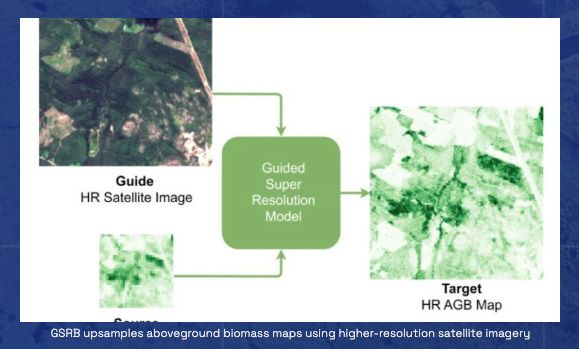
🌿 New research alert from #Embed2Scale ‼️
❓ How can we improve aboveground biomass mapping when only low-resolution data is available? 🛰️
📄 Read the publication: embed2scale.eu/download/gsr...
#EarthObservation #RemoteSensing #Biomass #Sentinel #AI4EO #Copernicus #GeospatialAI #ClimateData
❓ How can we improve aboveground biomass mapping when only low-resolution data is available? 🛰️
📄 Read the publication: embed2scale.eu/download/gsr...
#EarthObservation #RemoteSensing #Biomass #Sentinel #AI4EO #Copernicus #GeospatialAI #ClimateData
June 5, 2025 at 8:48 AM
🌿 New research alert from #Embed2Scale ‼️
❓ How can we improve aboveground biomass mapping when only low-resolution data is available? 🛰️
📄 Read the publication: embed2scale.eu/download/gsr...
#EarthObservation #RemoteSensing #Biomass #Sentinel #AI4EO #Copernicus #GeospatialAI #ClimateData
❓ How can we improve aboveground biomass mapping when only low-resolution data is available? 🛰️
📄 Read the publication: embed2scale.eu/download/gsr...
#EarthObservation #RemoteSensing #Biomass #Sentinel #AI4EO #Copernicus #GeospatialAI #ClimateData

Want to see AI in action on satellite imagery?
Check out what we’re building at FlyPix AI:
🔗 flypix.ai
From automated change detection to infrastructure monitoring – we turn pixels into decisions.
Curious? Let’s talk! 🚀🌍
#GeospatialAI #EarthObservation #Satellites #FlyPixAI
Check out what we’re building at FlyPix AI:
🔗 flypix.ai
From automated change detection to infrastructure monitoring – we turn pixels into decisions.
Curious? Let’s talk! 🚀🌍
#GeospatialAI #EarthObservation #Satellites #FlyPixAI
flypix.ai
July 2, 2025 at 7:21 AM
Want to see AI in action on satellite imagery?
Check out what we’re building at FlyPix AI:
🔗 flypix.ai
From automated change detection to infrastructure monitoring – we turn pixels into decisions.
Curious? Let’s talk! 🚀🌍
#GeospatialAI #EarthObservation #Satellites #FlyPixAI
Check out what we’re building at FlyPix AI:
🔗 flypix.ai
From automated change detection to infrastructure monitoring – we turn pixels into decisions.
Curious? Let’s talk! 🚀🌍
#GeospatialAI #EarthObservation #Satellites #FlyPixAI

🥈 We’re proud to announce that Datalayer secured 2nd place in the AI for Earthquake Response challenge by ESA Φ-lab!
Our approach: Siamese network, image registration, and more.
Infrastructure powered by Datalayer. 🚀
Full breakdown 👉 datalayer.blog/2025/09/12/a...
#GeospatialAI #DeepLearning
Our approach: Siamese network, image registration, and more.
Infrastructure powered by Datalayer. 🚀
Full breakdown 👉 datalayer.blog/2025/09/12/a...
#GeospatialAI #DeepLearning

How We Won the 2nd Place in the AI for Earthquake Response Challenge
Discover our approach to building AI models for rapid earthquake damage assessment using satellite imagery.
datalayer.blog
October 2, 2025 at 2:23 PM
🥈 We’re proud to announce that Datalayer secured 2nd place in the AI for Earthquake Response challenge by ESA Φ-lab!
Our approach: Siamese network, image registration, and more.
Infrastructure powered by Datalayer. 🚀
Full breakdown 👉 datalayer.blog/2025/09/12/a...
#GeospatialAI #DeepLearning
Our approach: Siamese network, image registration, and more.
Infrastructure powered by Datalayer. 🚀
Full breakdown 👉 datalayer.blog/2025/09/12/a...
#GeospatialAI #DeepLearning

🌍🧠 Geospatial AI evolves! Google's research links natural language and satellite data for faster insights. Dive in: research.google/blog/geospat... #GeospatialAI #GenerativeAI #ClimateTech #GoogleResearch

Geospatial Reasoning: Unlocking insights with generative AI and multiple foundation models
research.google
April 17, 2025 at 1:44 AM
🌍🧠 Geospatial AI evolves! Google's research links natural language and satellite data for faster insights. Dive in: research.google/blog/geospat... #GeospatialAI #GenerativeAI #ClimateTech #GoogleResearch

LGND raises $9M to help AI models analyze geospatial data #Technology #Business #Startups #GeospatialAI #FundingNews #TechStartups

LGND raises $9M to help AI models analyze geospatial data
LGND AI Inc. has raised $9 million in funding to enhance its namesake cloud platform, which helps artificial intelligence models process satellite images. The startup announced the seed round on Thursday....
puretech.news
July 11, 2025 at 9:02 PM
LGND raises $9M to help AI models analyze geospatial data #Technology #Business #Startups #GeospatialAI #FundingNews #TechStartups
📢 #Embed2Scale takes the stage on 📅 𝟲 𝗠𝗮𝘆 at the
🔹 𝗘𝗦𝗔-𝗡𝗔𝗦𝗔 𝗪𝗼𝗿𝗸𝘀𝗵𝗼𝗽 🔹 to present our work on AI-powered compression for #EarthObservation data:
❇️ 𝗝𝗢𝗜𝗡 𝗨𝗦
👉 embed2scale.eu/2025/04/03/e...
📌 “𝗘𝗮𝗿𝘁𝗵𝟮𝗩𝗲𝗰 𝗫𝗰𝗵𝗮𝗻𝗴𝗲:
👉 embed2scale.eu/2025/05/01/e...
@euspa.bsky.social
#FoundationModels #GeospatialAI
🔹 𝗘𝗦𝗔-𝗡𝗔𝗦𝗔 𝗪𝗼𝗿𝗸𝘀𝗵𝗼𝗽 🔹 to present our work on AI-powered compression for #EarthObservation data:
❇️ 𝗝𝗢𝗜𝗡 𝗨𝗦
👉 embed2scale.eu/2025/04/03/e...
📌 “𝗘𝗮𝗿𝘁𝗵𝟮𝗩𝗲𝗰 𝗫𝗰𝗵𝗮𝗻𝗴𝗲:
👉 embed2scale.eu/2025/05/01/e...
@euspa.bsky.social
#FoundationModels #GeospatialAI
May 2, 2025 at 11:42 AM
📢 #Embed2Scale takes the stage on 📅 𝟲 𝗠𝗮𝘆 at the
🔹 𝗘𝗦𝗔-𝗡𝗔𝗦𝗔 𝗪𝗼𝗿𝗸𝘀𝗵𝗼𝗽 🔹 to present our work on AI-powered compression for #EarthObservation data:
❇️ 𝗝𝗢𝗜𝗡 𝗨𝗦
👉 embed2scale.eu/2025/04/03/e...
📌 “𝗘𝗮𝗿𝘁𝗵𝟮𝗩𝗲𝗰 𝗫𝗰𝗵𝗮𝗻𝗴𝗲:
👉 embed2scale.eu/2025/05/01/e...
@euspa.bsky.social
#FoundationModels #GeospatialAI
🔹 𝗘𝗦𝗔-𝗡𝗔𝗦𝗔 𝗪𝗼𝗿𝗸𝘀𝗵𝗼𝗽 🔹 to present our work on AI-powered compression for #EarthObservation data:
❇️ 𝗝𝗢𝗜𝗡 𝗨𝗦
👉 embed2scale.eu/2025/04/03/e...
📌 “𝗘𝗮𝗿𝘁𝗵𝟮𝗩𝗲𝗰 𝗫𝗰𝗵𝗮𝗻𝗴𝗲:
👉 embed2scale.eu/2025/05/01/e...
@euspa.bsky.social
#FoundationModels #GeospatialAI

🚀 Our first BEGIN Seminar of 2025 is happening next week! 🗓 Feb 25 | 15:00| Online (Teams) 🎙 Dr. Weiming Huang (Univ. of Leeds) will talk about Geospatial Foundation Models—how large-scale models can transform geospatial analysis. Register here
#GeospatialAI #FoundationModels #BEGINseminar
#GeospatialAI #FoundationModels #BEGINseminar

February 22, 2025 at 3:13 PM
🚀 Our first BEGIN Seminar of 2025 is happening next week! 🗓 Feb 25 | 15:00| Online (Teams) 🎙 Dr. Weiming Huang (Univ. of Leeds) will talk about Geospatial Foundation Models—how large-scale models can transform geospatial analysis. Register here
#GeospatialAI #FoundationModels #BEGINseminar
#GeospatialAI #FoundationModels #BEGINseminar
Venue: DSN Geospatial Training Telegram Group.
Not on the group yet?
Join here>https://t.me/+4M0CWRbB0NMxYWI0
#datasciencenigeria #GeospatialAI
Not on the group yet?
Join here>https://t.me/+4M0CWRbB0NMxYWI0
#datasciencenigeria #GeospatialAI
July 8, 2025 at 1:10 PM
Venue: DSN Geospatial Training Telegram Group.
Not on the group yet?
Join here>https://t.me/+4M0CWRbB0NMxYWI0
#datasciencenigeria #GeospatialAI
Not on the group yet?
Join here>https://t.me/+4M0CWRbB0NMxYWI0
#datasciencenigeria #GeospatialAI

New AI Model Forecasts Wildfire Activity by Tracking Fuel, Not Just Fire Risk
#AI #AIforecasting #WildfirePrediction #ClimateTech #MachineLearning #EnvironmentalAI #ECMWF #PoFmodel #WeatherAI #FireRisk #GeospatialAI
#AI #AIforecasting #WildfirePrediction #ClimateTech #MachineLearning #EnvironmentalAI #ECMWF #PoFmodel #WeatherAI #FireRisk #GeospatialAI

New AI Model Forecasts Wildfire Activity by Tracking Fuel, Not Just Fire Risk - WinBuzzer
ECMWF has developed an AI model that forecasts actual wildfire activity using data on vegetation, weather, and ignition sources.
winbuzzer.com
April 2, 2025 at 1:41 PM
New AI Model Forecasts Wildfire Activity by Tracking Fuel, Not Just Fire Risk
#AI #AIforecasting #WildfirePrediction #ClimateTech #MachineLearning #EnvironmentalAI #ECMWF #PoFmodel #WeatherAI #FireRisk #GeospatialAI
#AI #AIforecasting #WildfirePrediction #ClimateTech #MachineLearning #EnvironmentalAI #ECMWF #PoFmodel #WeatherAI #FireRisk #GeospatialAI
Topic: Spatio-Temporal Crime Hotspot Analysis using QGIS: From Data to Decision-Making.
Date: Friday, 10th October 2025
Time: 4:00pm
Venue: DSN Community Telegram Channel.
#datasciencenigeria #GeospatialAI #QGIS
Date: Friday, 10th October 2025
Time: 4:00pm
Venue: DSN Community Telegram Channel.
#datasciencenigeria #GeospatialAI #QGIS
October 7, 2025 at 4:50 PM
Topic: Spatio-Temporal Crime Hotspot Analysis using QGIS: From Data to Decision-Making.
Date: Friday, 10th October 2025
Time: 4:00pm
Venue: DSN Community Telegram Channel.
#datasciencenigeria #GeospatialAI #QGIS
Date: Friday, 10th October 2025
Time: 4:00pm
Venue: DSN Community Telegram Channel.
#datasciencenigeria #GeospatialAI #QGIS
Whether you joined Part 1 or not, this is your chance to catch the wave of smarter geospatial work.
No more manual steps. Just smart code, fast results
#datasciencenigeria #GeospatialAI
No more manual steps. Just smart code, fast results
#datasciencenigeria #GeospatialAI
August 6, 2025 at 10:56 AM
Whether you joined Part 1 or not, this is your chance to catch the wave of smarter geospatial work.
No more manual steps. Just smart code, fast results
#datasciencenigeria #GeospatialAI
No more manual steps. Just smart code, fast results
#datasciencenigeria #GeospatialAI

KOJIMA PRODUCTIONS 10周年記念イベント
「Beyond The Strand」
Niantic Spatial との技術的パートナーシップを締結を発表
#KojimaProductions #KJP10th #NianticSpatial #GeospatialAI
「Beyond The Strand」
Niantic Spatial との技術的パートナーシップを締結を発表
#KojimaProductions #KJP10th #NianticSpatial #GeospatialAI
September 24, 2025 at 2:23 PM
KOJIMA PRODUCTIONS 10周年記念イベント
「Beyond The Strand」
Niantic Spatial との技術的パートナーシップを締結を発表
#KojimaProductions #KJP10th #NianticSpatial #GeospatialAI
「Beyond The Strand」
Niantic Spatial との技術的パートナーシップを締結を発表
#KojimaProductions #KJP10th #NianticSpatial #GeospatialAI

🙌 Huge thanks to the team:
Muhammad Sohail Danish, Muhammad Akhtar Munir, Syed Roshaan Ali Shah, Kartik Kuckreja, Fahad Khan, Paolo Fraccaro, Alexandre Lacoste, Salman Khan
Follow for updates!
#ICCV2025 #VLMs #AI4EO #RemoteSensing #GeospatialAI #MachineLearning #Benchmarking
Muhammad Sohail Danish, Muhammad Akhtar Munir, Syed Roshaan Ali Shah, Kartik Kuckreja, Fahad Khan, Paolo Fraccaro, Alexandre Lacoste, Salman Khan
Follow for updates!
#ICCV2025 #VLMs #AI4EO #RemoteSensing #GeospatialAI #MachineLearning #Benchmarking
July 2, 2025 at 12:47 PM
🙌 Huge thanks to the team:
Muhammad Sohail Danish, Muhammad Akhtar Munir, Syed Roshaan Ali Shah, Kartik Kuckreja, Fahad Khan, Paolo Fraccaro, Alexandre Lacoste, Salman Khan
Follow for updates!
#ICCV2025 #VLMs #AI4EO #RemoteSensing #GeospatialAI #MachineLearning #Benchmarking
Muhammad Sohail Danish, Muhammad Akhtar Munir, Syed Roshaan Ali Shah, Kartik Kuckreja, Fahad Khan, Paolo Fraccaro, Alexandre Lacoste, Salman Khan
Follow for updates!
#ICCV2025 #VLMs #AI4EO #RemoteSensing #GeospatialAI #MachineLearning #Benchmarking

IBM et l’ESA lancent TerraMind, une IA open source pour analyser les données géospatiales et améliorer la surveillance environnementale 🌍🛰️. #GeospatialAI
👉 [lire]
👉 [lire]

April 24, 2025 at 6:23 AM
IBM et l’ESA lancent TerraMind, une IA open source pour analyser les données géospatiales et améliorer la surveillance environnementale 🌍🛰️. #GeospatialAI
👉 [lire]
👉 [lire]