


Damian
@spangrud.bsky.social
Geographer (he/him) working in tech (@esri), focused on spatial thinking and understanding. Map, Food, Travel, Kites...

November 13, 2025 at 4:40 PM
#30DayMapChallenge Day 12 – Map from 2125
With the rising ocean levels and after the fast-food wars of the early 2100s, coastal communities reorganized around being island nations.
With the rising ocean levels and after the fast-food wars of the early 2100s, coastal communities reorganized around being island nations.

November 12, 2025 at 4:19 PM
#30DayMapChallenge Day 12 – Map from 2125
With the rising ocean levels and after the fast-food wars of the early 2100s, coastal communities reorganized around being island nations.
With the rising ocean levels and after the fast-food wars of the early 2100s, coastal communities reorganized around being island nations.
#30DayMapChallenge Day 11 – Minimal Map.
Places I lived all visualized at 1:8M scale
(Projected Coordinate system: US National Atlas Equal Area (WKID 2163))
Places I lived all visualized at 1:8M scale
(Projected Coordinate system: US National Atlas Equal Area (WKID 2163))

November 12, 2025 at 4:09 AM
#30DayMapChallenge Day 11 – Minimal Map.
Places I lived all visualized at 1:8M scale
(Projected Coordinate system: US National Atlas Equal Area (WKID 2163))
Places I lived all visualized at 1:8M scale
(Projected Coordinate system: US National Atlas Equal Area (WKID 2163))
#30DayMapChallenge Accessibility
Edinburgh is a wonderful city. And it is generally accessible, however as with any city, some parts are more accessible than others. This map uses data from ArcGIS Online to show the accessibility score by postal codes.
Source data:
lnkd.in/gyktNmzv
Edinburgh is a wonderful city. And it is generally accessible, however as with any city, some parts are more accessible than others. This map uses data from ArcGIS Online to show the accessibility score by postal codes.
Source data:
lnkd.in/gyktNmzv

November 7, 2025 at 10:08 PM
#30DayMapChallenge Accessibility
Edinburgh is a wonderful city. And it is generally accessible, however as with any city, some parts are more accessible than others. This map uses data from ArcGIS Online to show the accessibility score by postal codes.
Source data:
lnkd.in/gyktNmzv
Edinburgh is a wonderful city. And it is generally accessible, however as with any city, some parts are more accessible than others. This map uses data from ArcGIS Online to show the accessibility score by postal codes.
Source data:
lnkd.in/gyktNmzv
#30dayMapChallenge
Revisiting my thesis data after 30+ years. The intersection of Percision ag, terrain and soil modeling. Happy to see the field is still (mostly) a field.
Revisiting my thesis data after 30+ years. The intersection of Percision ag, terrain and soil modeling. Happy to see the field is still (mostly) a field.

November 5, 2025 at 12:05 AM
#30dayMapChallenge
Revisiting my thesis data after 30+ years. The intersection of Percision ag, terrain and soil modeling. Happy to see the field is still (mostly) a field.
Revisiting my thesis data after 30+ years. The intersection of Percision ag, terrain and soil modeling. Happy to see the field is still (mostly) a field.


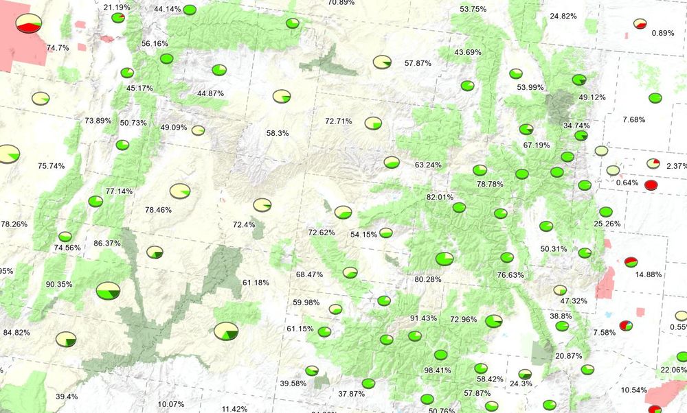
Interactive web map showing Federal land by State a nd county. Still needs some work, but getting swamped with other stuff so wanted to share while its still fresh in my mind. damian.maps.arcgis.com/apps/mapview...

May 28, 2025 at 6:12 PM
Interactive web map showing Federal land by State a nd county. Still needs some work, but getting swamped with other stuff so wanted to share while its still fresh in my mind. damian.maps.arcgis.com/apps/mapview...
rough Cartogram, sized based on amount of Federal Land within that state...

May 16, 2025 at 8:44 PM
rough Cartogram, sized based on amount of Federal Land within that state...
Playing with data on Federal land in each county and state. Living in the western US for many years, I forget how little of the Federal land is in the East. #geography

May 16, 2025 at 6:55 PM
Playing with data on Federal land in each county and state. Living in the western US for many years, I forget how little of the Federal land is in the East. #geography
I would happily go back this this indestructable jewel (plus it gives SciFi vibes).

February 6, 2025 at 4:30 PM
I would happily go back this this indestructable jewel (plus it gives SciFi vibes).