


Rusty Dawkins
@rustywx.bsky.social
Weather and the Huskers, in no particular order.
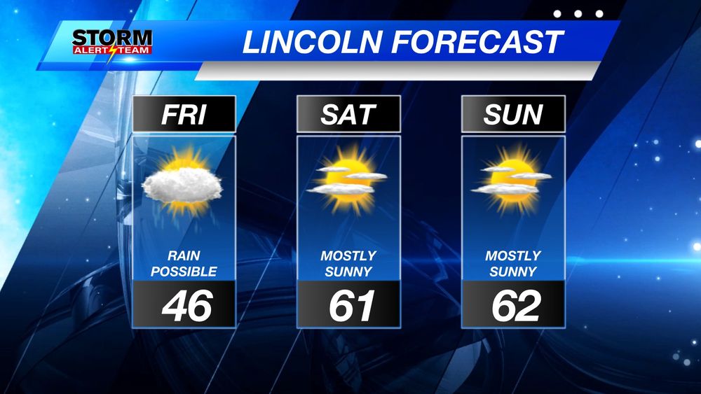
Trying to warm up on Tuesday, but with a fresh pack of snow on the ground, eastern Nebraska will be much colder than the western half!

December 2, 2025 at 4:08 AM
Trying to warm up on Tuesday, but with a fresh pack of snow on the ground, eastern Nebraska will be much colder than the western half!
Reports are trickling in and they range from 1.7" to 3" for SE Nebraska from the snow early Monday (Dec 1, 2025).
Saw quite a few 1" reports from Roca, Denton, Murdock, Raymond, and Seward, but that was as of 7-8am, so it probably wasn't done snowing by then.
Saw quite a few 1" reports from Roca, Denton, Murdock, Raymond, and Seward, but that was as of 7-8am, so it probably wasn't done snowing by then.

December 1, 2025 at 9:39 PM
Reports are trickling in and they range from 1.7" to 3" for SE Nebraska from the snow early Monday (Dec 1, 2025).
Saw quite a few 1" reports from Roca, Denton, Murdock, Raymond, and Seward, but that was as of 7-8am, so it probably wasn't done snowing by then.
Saw quite a few 1" reports from Roca, Denton, Murdock, Raymond, and Seward, but that was as of 7-8am, so it probably wasn't done snowing by then.
As expected, it's SNOWING Monday morning! We'll see around an inch or two after it's all said and done by late morning. Streets are slick, so take you're time getting to where you need to go!

December 1, 2025 at 2:36 PM
As expected, it's SNOWING Monday morning! We'll see around an inch or two after it's all said and done by late morning. Streets are slick, so take you're time getting to where you need to go!
A quick hitting system will drop a trace to 1" of fluffy snow Monday, with 1-2", possibly up to 4", in far SE Nebraska. Winter Wx Adv is in place.
Starts in western Nebraska late Sunday, into central Nebraska overnight, then into eastern Nebraska AM Monday. Lingers into Monday.
Starts in western Nebraska late Sunday, into central Nebraska overnight, then into eastern Nebraska AM Monday. Lingers into Monday.


November 30, 2025 at 3:32 PM
A quick hitting system will drop a trace to 1" of fluffy snow Monday, with 1-2", possibly up to 4", in far SE Nebraska. Winter Wx Adv is in place.
Starts in western Nebraska late Sunday, into central Nebraska overnight, then into eastern Nebraska AM Monday. Lingers into Monday.
Starts in western Nebraska late Sunday, into central Nebraska overnight, then into eastern Nebraska AM Monday. Lingers into Monday.
Winter Weather Advisory is now in place for much of Nebraska through Saturday morning. Freezing drizzle/rain changing to 1-2" of snow through Saturday morning. 2-4" to the north. Several more inches of snow possible closer to Iowa in the Winter Storm Warning counties. Lots of wind on Saturday, too.


November 28, 2025 at 7:08 PM
Winter Weather Advisory is now in place for much of Nebraska through Saturday morning. Freezing drizzle/rain changing to 1-2" of snow through Saturday morning. 2-4" to the north. Several more inches of snow possible closer to Iowa in the Winter Storm Warning counties. Lots of wind on Saturday, too.
Wondering what all of the weather models are saying for snowfall potential on Saturday? I will be doing videos like this with every winter storm so if this is something that interests you, give me a like/sub on the old tube!
I've added my snowfall potential map for context:
youtu.be/46lGJW2QwWg
I've added my snowfall potential map for context:
youtu.be/46lGJW2QwWg

November 28, 2025 at 12:09 AM
Wondering what all of the weather models are saying for snowfall potential on Saturday? I will be doing videos like this with every winter storm so if this is something that interests you, give me a like/sub on the old tube!
I've added my snowfall potential map for context:
youtu.be/46lGJW2QwWg
I've added my snowfall potential map for context:
youtu.be/46lGJW2QwWg
Winter Weather Advisories are in place for northeast Nebraska with Winter Storm Warnings into Iowa. This starts Friday morning and goes through Saturday.
Light snow/frz rain/mix is possible Friday, then changing to snow early Saturday. The bulk of the snow will be in Iowa.
Light snow/frz rain/mix is possible Friday, then changing to snow early Saturday. The bulk of the snow will be in Iowa.

November 27, 2025 at 9:46 PM
Winter Weather Advisories are in place for northeast Nebraska with Winter Storm Warnings into Iowa. This starts Friday morning and goes through Saturday.
Light snow/frz rain/mix is possible Friday, then changing to snow early Saturday. The bulk of the snow will be in Iowa.
Light snow/frz rain/mix is possible Friday, then changing to snow early Saturday. The bulk of the snow will be in Iowa.
This shows 10am Saturday, Nov 29th. It's when the rain in SE Nebraska is expected to change to snow. It will then push east. When this changes over to snow, how fast it moves east, and dry air will be big factors in our snow totals. My 1-2" still feels right for #LNK.

November 27, 2025 at 8:37 PM
This shows 10am Saturday, Nov 29th. It's when the rain in SE Nebraska is expected to change to snow. It will then push east. When this changes over to snow, how fast it moves east, and dry air will be big factors in our snow totals. My 1-2" still feels right for #LNK.
-Heaviest snow will be in northeast Nebraska.
-Omaha to Norfolk is on the edge, so 2-4" there.
-Lincoln is further away, so 1-2" there to O'Neill and Chadron. Rain limits higher snow totals in SE Nebraska as well.
-A north wind will also be blowing at 20-30 mph on Saturday.
-Omaha to Norfolk is on the edge, so 2-4" there.
-Lincoln is further away, so 1-2" there to O'Neill and Chadron. Rain limits higher snow totals in SE Nebraska as well.
-A north wind will also be blowing at 20-30 mph on Saturday.

November 27, 2025 at 12:14 AM
-Heaviest snow will be in northeast Nebraska.
-Omaha to Norfolk is on the edge, so 2-4" there.
-Lincoln is further away, so 1-2" there to O'Neill and Chadron. Rain limits higher snow totals in SE Nebraska as well.
-A north wind will also be blowing at 20-30 mph on Saturday.
-Omaha to Norfolk is on the edge, so 2-4" there.
-Lincoln is further away, so 1-2" there to O'Neill and Chadron. Rain limits higher snow totals in SE Nebraska as well.
-A north wind will also be blowing at 20-30 mph on Saturday.
Oof. 55 mph wind gust in Lincoln as of 4pm.

November 25, 2025 at 10:11 PM
Oof. 55 mph wind gust in Lincoln as of 4pm.
High Wind Warnings and Wind Advisories are in place for most of the state of Nebraska Tuesday, November 25, 2025. Wind in excess of 55 mph is possible in the warning area. Wind up to 50 mph will be possible in the advisory area. Overall, it's going to be a WINDY day!

November 25, 2025 at 2:05 PM
High Wind Warnings and Wind Advisories are in place for most of the state of Nebraska Tuesday, November 25, 2025. Wind in excess of 55 mph is possible in the warning area. Wind up to 50 mph will be possible in the advisory area. Overall, it's going to be a WINDY day!
Oof. LOTS of wind Tuesday. At least it won't be terribly cold, too!


November 25, 2025 at 4:01 AM
Oof. LOTS of wind Tuesday. At least it won't be terribly cold, too!
High Wind Warnings/Watches and Wind Advisories are in place Tuesday.
Wind out of the NW may exceed 55 mph in the High Wind Watch/Warning. Up to 50 mph in the Wind Advisory. Those near the watches, warnings, and advisories will see wind gusts in excess of 40 mph.
Wind out of the NW may exceed 55 mph in the High Wind Watch/Warning. Up to 50 mph in the Wind Advisory. Those near the watches, warnings, and advisories will see wind gusts in excess of 40 mph.

November 24, 2025 at 8:31 PM
High Wind Warnings/Watches and Wind Advisories are in place Tuesday.
Wind out of the NW may exceed 55 mph in the High Wind Watch/Warning. Up to 50 mph in the Wind Advisory. Those near the watches, warnings, and advisories will see wind gusts in excess of 40 mph.
Wind out of the NW may exceed 55 mph in the High Wind Watch/Warning. Up to 50 mph in the Wind Advisory. Those near the watches, warnings, and advisories will see wind gusts in excess of 40 mph.
I'm very excited about this weekend!

November 22, 2025 at 4:28 AM
I'm very excited about this weekend!
One more gray day with rain chances, then a top 10 November weekend is headed our way in Lincoln!
November 21, 2025 at 3:35 AM
One more gray day with rain chances, then a top 10 November weekend is headed our way in Lincoln!
Another quiet day on Thursday in Lincoln, then rain likely on Friday. After a lot of 50s and 60s the next several days, cooler air moves in over the Thanksgiving weekend!

November 20, 2025 at 4:26 AM
Another quiet day on Thursday in Lincoln, then rain likely on Friday. After a lot of 50s and 60s the next several days, cooler air moves in over the Thanksgiving weekend!
SEVERE THUNDERSTORM WARNING: For Lancaster and Seward County. Until 9:15 PM. Quarter size hail possible. Storm is moving northeast at 30 mph.

November 18, 2025 at 2:59 AM
SEVERE THUNDERSTORM WARNING: For Lancaster and Seward County. Until 9:15 PM. Quarter size hail possible. Storm is moving northeast at 30 mph.
Just before 8:30 PM, Monday, November 17, and there are scattered showers and thunderstorms everywhere. They are all moving to the northeast. Small hail, lots of lightning, and heavy rain likely. 

November 18, 2025 at 2:32 AM
Just before 8:30 PM, Monday, November 17, and there are scattered showers and thunderstorms everywhere. They are all moving to the northeast. Small hail, lots of lightning, and heavy rain likely. 
NEW RECORD HIGHS! (as of 2pm)
It's 77 in Lincoln, which breaks the old record of 75 set in 1990.
Other previous records:
Omaha: 76 (1964)
Norfolk: 72 (2001)
GI: 71 (2001)
Hastings: 74 (1990)
McCook: 78 (1990)
Ainsworth: 80 (1990)
North Platte: 78 (1990)
Valentine: 79 (1990)
It's 77 in Lincoln, which breaks the old record of 75 set in 1990.
Other previous records:
Omaha: 76 (1964)
Norfolk: 72 (2001)
GI: 71 (2001)
Hastings: 74 (1990)
McCook: 78 (1990)
Ainsworth: 80 (1990)
North Platte: 78 (1990)
Valentine: 79 (1990)

November 14, 2025 at 8:30 PM
NEW RECORD HIGHS! (as of 2pm)
It's 77 in Lincoln, which breaks the old record of 75 set in 1990.
Other previous records:
Omaha: 76 (1964)
Norfolk: 72 (2001)
GI: 71 (2001)
Hastings: 74 (1990)
McCook: 78 (1990)
Ainsworth: 80 (1990)
North Platte: 78 (1990)
Valentine: 79 (1990)
It's 77 in Lincoln, which breaks the old record of 75 set in 1990.
Other previous records:
Omaha: 76 (1964)
Norfolk: 72 (2001)
GI: 71 (2001)
Hastings: 74 (1990)
McCook: 78 (1990)
Ainsworth: 80 (1990)
North Platte: 78 (1990)
Valentine: 79 (1990)
75 is the record high for Lincoln tomorrow. That was set in 1990. I was still in high school!

November 14, 2025 at 3:24 AM
75 is the record high for Lincoln tomorrow. That was set in 1990. I was still in high school!
Really warm, then cooling off with rain chances next week in Lincoln. Might see some snow mix in late next week!

November 13, 2025 at 3:42 AM
Really warm, then cooling off with rain chances next week in Lincoln. Might see some snow mix in late next week!

Very mild couple of days ahead, then a transition day on Saturday with some light mixed precip late Saturday. Much colder by Sunday and Monday!

November 6, 2025 at 4:24 AM
Very mild couple of days ahead, then a transition day on Saturday with some light mixed precip late Saturday. Much colder by Sunday and Monday!
This rain snow mix has been persistently showing up in models for a few days now and keeps pushing it further and further west into eastern Nebraska.
It's only Wednesday and this is for Saturday night, so lots of time to fine tune the deets!
It's only Wednesday and this is for Saturday night, so lots of time to fine tune the deets!

November 5, 2025 at 10:30 PM
This rain snow mix has been persistently showing up in models for a few days now and keeps pushing it further and further west into eastern Nebraska.
It's only Wednesday and this is for Saturday night, so lots of time to fine tune the deets!
It's only Wednesday and this is for Saturday night, so lots of time to fine tune the deets!
A toasty few days ahead! (Nov 5-7, 2025)

November 5, 2025 at 4:26 AM
A toasty few days ahead! (Nov 5-7, 2025)