


New England Storm Center
@nestormcenter.bsky.social
Complete New England Storm and weather coverage. Owner of NewEnglandStormCenter.com
After a quick hit of snow showers Tuesday night, another system rapidly follows behind for Wednesday. This system will be more organized. It will run inland, bringing snow/mix to rain for coastal areas with snow well inland. Snowfall will be elevation-based. #MAwx #CTwx #RIwx #NHwx #MEwx #VTwx


December 8, 2025 at 10:59 PM
A quick clipper will drop an inch or 2 of snow tonight for northernmost New England. Another clipper brings snow showers Tuesday night. A more organized system will move through midweek. This will be an inside runner with high elevation snow & coastal plain rain. #MAwx #CTwx #RIwx #NHwx #MEwx #VTwx


December 7, 2025 at 10:32 PM

A couple systems will zip thru New England this weekend. A coastal storm stays well offshore Saturday with another system to the north. This will result in a few snow showers. Sunday night will see a clipper system swing thru, bringing a quick hit of snow to some. #MAwx #CTwx #RIwx #NHwx #MEwx #VTwx


December 6, 2025 at 12:07 AM
A couple systems will zip thru New England this weekend. A coastal storm stays well offshore Saturday with another system to the north. This will result in a few snow showers. Sunday night will see a clipper system swing thru, bringing a quick hit of snow to some. #MAwx #CTwx #RIwx #NHwx #MEwx #VTwx

An arctic front drops through New England Thursday. This will likely spark snow squalls across interior northern New England. These squalls will likely begin to weaken and fall apart moving south in New England. Very cold temperatures will follow. #MAwx #CTwx #RIwx #NHwx #MEwx #VTwx


December 4, 2025 at 12:30 AM


Not much change in overall thinking this morning. The biggest area of uncertainty in total snowfall remains the coastal plain from about Gloucester through Portland. The jackpot zone looks to set up across central New Hampshire and southern Vermont. #MAwx #CTwx #RIwx #NHwx #MEwx #VTwx


December 2, 2025 at 1:17 PM
Only minor adjustments to our snowfall map from this morning, mainly to shift snow totals a bit farther north/west. Mild air off the ocean & a quick-hitting storm will help keep snowfall in check for many. Still expect a band of 6-10+" across central New England. #MAwx #CTwx #RIwx #NHwx #MEwx #VTwx


December 1, 2025 at 10:23 PM

This continues to look like a wide 4-8" jackpot zone type storm. A narrow mesoscale band will likely set up within the jackpot zone, leading to some higher amounts. How close the higher snowfall makes it to the coast remains the biggest question. #MAwx #CTwx #RIwx #NHwx #MEwx #VTwx


November 30, 2025 at 11:48 PM
Tuesday's storm will be all about the track.This will determine where a rain/snow line sets up.There may be a sharp cutoff in the highest snow, which will occur just north of where the storm stays all snow. Recent trends have pointed to an earlier arrival as well. #MAwx #CTwx #RIwx #NHwx #MEwx #VTwx


November 29, 2025 at 10:40 PM
Tuesday's storm will be all about the track.This will determine where a rain/snow line sets up.There may be a sharp cutoff in the highest snow, which will occur just north of where the storm stays all snow. Recent trends have pointed to an earlier arrival as well. #MAwx #CTwx #RIwx #NHwx #MEwx #VTwx
Not much change for the quick-hitting storm tomorrow. This storm brought a decent snowstorm to parts of the Midwest, but it will rise north of New England, leading to a milder storm. It'll still be cold enough for a couple inches across the north. #MAwx #NHwx #MEwx #VTwx #CTwx


November 29, 2025 at 9:42 PM


Update on New England's 2 incoming storms.Sunday remains on track as a quick hitter w/ minor snow in the north country.Tuesday will come down to how close the track is to the coast, but this will be a stronger storm with more snow (several inches in jackpot zone). #MAwx #CTwx #RIwx #NHwx #MEwx #VTwx


November 28, 2025 at 11:14 PM
Update on New England's 2 incoming storms.Sunday remains on track as a quick hitter w/ minor snow in the north country.Tuesday will come down to how close the track is to the coast, but this will be a stronger storm with more snow (several inches in jackpot zone). #MAwx #CTwx #RIwx #NHwx #MEwx #VTwx
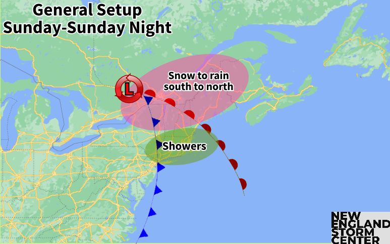
A couple more storms on the way for New England.Next is an inside runner Sun to Mon, bringing rain south & snow/mix to rain across interior northern areas.More widespread wintry weather is possible Tuesday to Wednesday.Cold will be persistent to kick off December. #MAwx #CTwx #RIwx #NHwx #MEwx #VTwx


November 27, 2025 at 11:57 PM
A couple more storms on the way for New England.Next is an inside runner Sun to Mon, bringing rain south & snow/mix to rain across interior northern areas.More widespread wintry weather is possible Tuesday to Wednesday.Cold will be persistent to kick off December. #MAwx #CTwx #RIwx #NHwx #MEwx #VTwx
After a mainly dry, albeit chilly & blustery Thanksgiving, New England will stay generally active. Upslope snows likely on Friday. A mix/rain event is on tap for Sunday into Monday. Another, potentially colder system may arrive around midweek. #MAwx #CTwx #RIwx #NHwx #MEwx #VTwx


November 27, 2025 at 12:20 AM
Temperatures will begin to warm tonight as a warm front lifts through New England. Warming will continue through Wed afternoon. Cold front moves through tomorrow night, sparking a sharp cool-down and blustery weather for Thanksgiving. #MAwx #CTwx #RIwx #NHwx #MEwx #VTwx


November 26, 2025 at 12:05 AM
No big storms for Thanksgiving this year in New England like last year. There will be some rain (and a bit of mixing for far northern areas) just before the holiday. The holiday will be blustery with cooling weather from a cold front. #MAwx #CTwx #RIwx #NHwx #MEwx #VTwx


November 25, 2025 at 12:24 AM
New England's weather will remain mostly quiet through Thanksgiving. Some southern showers tomorrow morning with more showers from a low-impact system around mid-week. New England will once again be within a trough after Thanksgiving as colder air pours in. #MAwx #CTwx #RIwx #NHwx #MEwx #VTwx


November 22, 2025 at 1:00 AM
It's been a rather quick start to the winter season. Maximum snow depth for this date from the NWS snow analyses is 25.9", which is tied for 2nd highest since 2005 (some mountains in Vermont are reporting even more). 57.9% of northeast has snow cover, tied for 5th since 2005. #MAwx #VTwx #NHwx #MEwx


November 19, 2025 at 1:07 AM
It's been a rather quick start to the winter season. Maximum snow depth for this date from the NWS snow analyses is 25.9", which is tied for 2nd highest since 2005 (some mountains in Vermont are reporting even more). 57.9% of northeast has snow cover, tied for 5th since 2005. #MAwx #VTwx #NHwx #MEwx


