Kyle Barron
@kylebarron.dev
Creating the next generation of geospatial data tools for Python & the browser with GeoArrow, GeoParquet & GeoRust @developmentseed | he/him 🌈
Released Lonboard v0.13!
- New layer types: H3, S2, Geohash, A5 and fixed HeatmapLayer
- Render data layers beneath Maplibre text labels
- Map UI controls: scale, fullscreen, navigation
- Significant performance improvements: fixing earlier regressions
developmentseed.org/lonboard/lat...
- New layer types: H3, S2, Geohash, A5 and fixed HeatmapLayer
- Render data layers beneath Maplibre text labels
- Map UI controls: scale, fullscreen, navigation
- Significant performance improvements: fixing earlier regressions
developmentseed.org/lonboard/lat...


November 5, 2025 at 9:26 PM
Released Lonboard v0.13!
- New layer types: H3, S2, Geohash, A5 and fixed HeatmapLayer
- Render data layers beneath Maplibre text labels
- Map UI controls: scale, fullscreen, navigation
- Significant performance improvements: fixing earlier regressions
developmentseed.org/lonboard/lat...
- New layer types: H3, S2, Geohash, A5 and fixed HeatmapLayer
- Render data layers beneath Maplibre text labels
- Map UI controls: scale, fullscreen, navigation
- Significant performance improvements: fixing earlier regressions
developmentseed.org/lonboard/lat...
New blog post! kylebarron.dev/blog/fast-py...
This dives into performance pitfalls of Python bindings, why projects like Lonboard are so fast, and why I care about Apache Arrow so much. The post is high level and you don't need to know C/C++/Rust to understand it!
This dives into performance pitfalls of Python bindings, why projects like Lonboard are so fast, and why I care about Apache Arrow so much. The post is high level and you don't need to know C/C++/Rust to understand it!

October 7, 2025 at 2:05 PM
New blog post! kylebarron.dev/blog/fast-py...
This dives into performance pitfalls of Python bindings, why projects like Lonboard are so fast, and why I care about Apache Arrow so much. The post is high level and you don't need to know C/C++/Rust to understand it!
This dives into performance pitfalls of Python bindings, why projects like Lonboard are so fast, and why I care about Apache Arrow so much. The post is high level and you don't need to know C/C++/Rust to understand it!
New Lonboard release and new demo! Integrating marimo and Apache DataFusion to visualize the NYC taxi dataset. developmentseed.org/lonboard/lat...
September 18, 2025 at 8:02 PM
New Lonboard release and new demo! Integrating marimo and Apache DataFusion to visualize the NYC taxi dataset. developmentseed.org/lonboard/lat...
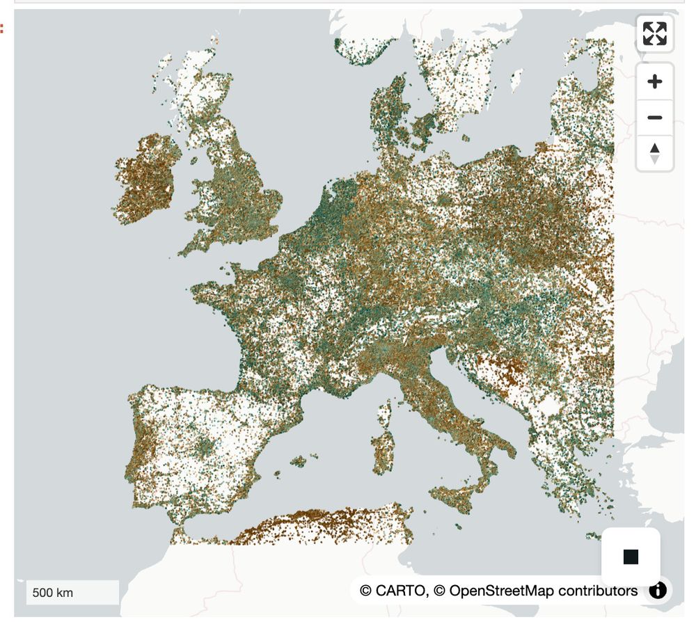
New example notebook on visualizing Spatially-Partitioned GeoParquet with Lonboard, Obstore, and GeoArrow-Rust, using Overture Maps Foundation data! developmentseed.org/lonboard/lat...
July 22, 2025 at 1:35 PM
New example notebook on visualizing Spatially-Partitioned GeoParquet with Lonboard, Obstore, and GeoArrow-Rust, using Overture Maps Foundation data! developmentseed.org/lonboard/lat...
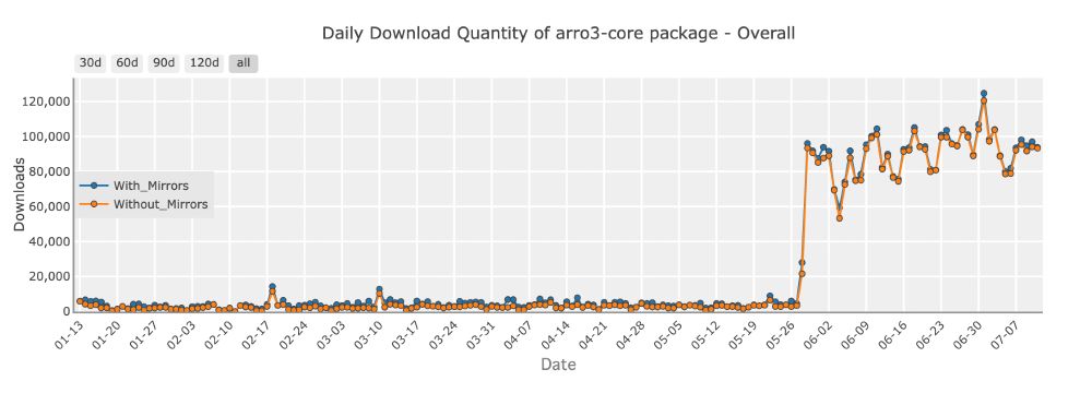
When the Delta Lake Python bindings take a required dependency on your library 😅. 2.6M downloads a month! 😱 Guess I'll never be making a breaking release now!! pypistats.org/packages/arr...
arro3-core is 15x smaller in your environment than pyarrow! kylebarron.dev/arro3/latest/
arro3-core is 15x smaller in your environment than pyarrow! kylebarron.dev/arro3/latest/
July 12, 2025 at 5:06 PM
When the Delta Lake Python bindings take a required dependency on your library 😅. 2.6M downloads a month! 😱 Guess I'll never be making a breaking release now!! pypistats.org/packages/arr...
arro3-core is 15x smaller in your environment than pyarrow! kylebarron.dev/arro3/latest/
arro3-core is 15x smaller in your environment than pyarrow! kylebarron.dev/arro3/latest/
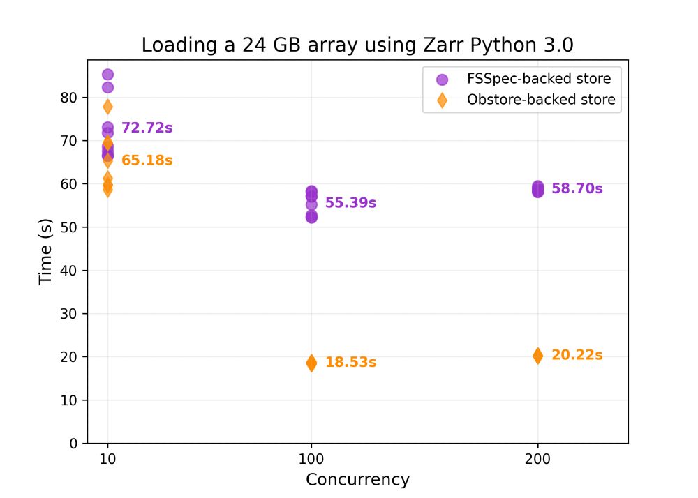
With today's Zarr Python release, switch to the new obstore-based backend for **3x faster** reading from S3, Google Cloud Storage, and Azure than the default fsspec backend.
zarr.readthedocs.io/en/stable/us...
developmentseed.org/obstore/late...
zarr.readthedocs.io/en/stable/us...
developmentseed.org/obstore/late...
April 21, 2025 at 2:28 PM
With today's Zarr Python release, switch to the new obstore-based backend for **3x faster** reading from S3, Google Cloud Storage, and Azure than the default fsspec backend.
zarr.readthedocs.io/en/stable/us...
developmentseed.org/obstore/late...
zarr.readthedocs.io/en/stable/us...
developmentseed.org/obstore/late...
I'm looking forward to the Cloud Native Geo conference next month!
I'll be presenting on Obstore and a growing ecosystem of Python libraries that enjoy faster, simpler access to cloud resources.
I'll be presenting on Obstore and a growing ecosystem of Python libraries that enjoy faster, simpler access to cloud resources.

March 31, 2025 at 7:53 PM
I'm looking forward to the Cloud Native Geo conference next month!
I'll be presenting on Obstore and a growing ecosystem of Python libraries that enjoy faster, simpler access to cloud resources.
I'll be presenting on Obstore and a growing ecosystem of Python libraries that enjoy faster, simpler access to cloud resources.
Spatial indexes, and RTrees specifically, are at the core of geospatial software.
But ever wondered how an RTree is actually implemented?
In this post we’ll dive into the implementation of Flatbush, an elegant, blazing-fast, memory-efficient RTree.
kylebarron.dev/literate-fla...
But ever wondered how an RTree is actually implemented?
In this post we’ll dive into the implementation of Flatbush, an elegant, blazing-fast, memory-efficient RTree.
kylebarron.dev/literate-fla...
January 8, 2025 at 3:43 PM
Spatial indexes, and RTrees specifically, are at the core of geospatial software.
But ever wondered how an RTree is actually implemented?
In this post we’ll dive into the implementation of Flatbush, an elegant, blazing-fast, memory-efficient RTree.
kylebarron.dev/literate-fla...
But ever wondered how an RTree is actually implemented?
In this post we’ll dive into the implementation of Flatbush, an elegant, blazing-fast, memory-efficient RTree.
kylebarron.dev/literate-fla...

Got the *most basic* proof of concept working for spatial support in DataFusion. Surprisingly easy to piece everything together

December 12, 2024 at 4:57 PM
Got the *most basic* proof of concept working for spatial support in DataFusion. Surprisingly easy to piece everything together