


Joel Masselink
@jmasselink.bsky.social
nature, geospatial, current events, and sports
#30DayMapChallenge
Day 11 - minimal
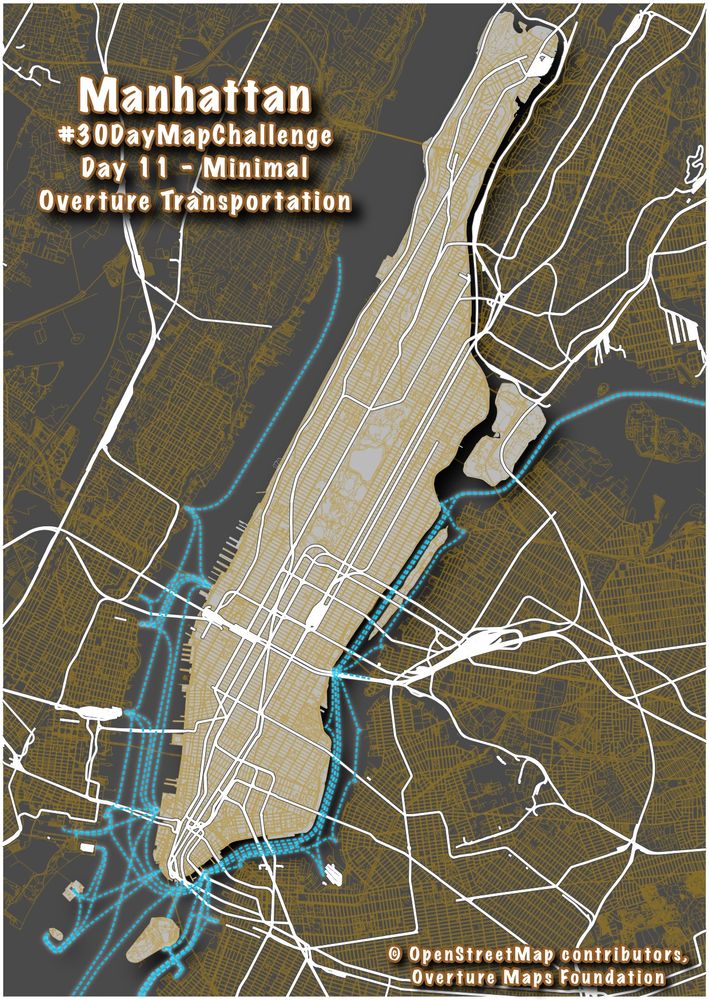
Transportation in Manhattan (ferries, rail, streets)
Data from OpenStreetMap & Overture Maps Foundation
Day 11 - minimal
Transportation in Manhattan (ferries, rail, streets)
Data from OpenStreetMap & Overture Maps Foundation
November 13, 2025 at 4:04 PM
#30DayMapChallenge
Day 11 - minimal
Transportation in Manhattan (ferries, rail, streets)
Data from OpenStreetMap & Overture Maps Foundation
Day 11 - minimal
Transportation in Manhattan (ferries, rail, streets)
Data from OpenStreetMap & Overture Maps Foundation
#30daymapchallenge
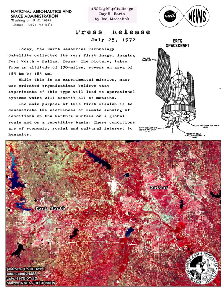
Day 5: Earth
A "press release" announcing Landsat 1's first image capture, of Fort Worth-Dallas, Texas on July 25, 1972.
Day 5: Earth
A "press release" announcing Landsat 1's first image capture, of Fort Worth-Dallas, Texas on July 25, 1972.
November 7, 2025 at 3:21 AM
#30daymapchallenge
Day 5: Earth
A "press release" announcing Landsat 1's first image capture, of Fort Worth-Dallas, Texas on July 25, 1972.
Day 5: Earth
A "press release" announcing Landsat 1's first image capture, of Fort Worth-Dallas, Texas on July 25, 1972.
On a roadtrip I stayed at a historic hotel which was in total disarray after hosting a 4-day retreat of #Blackstone
I had to look up more to learn more about this group, whose CEO Stephen Schwarzman is worth ~$48 Billion.
Plutocrats gonna plute...moving with the political winds...
I had to look up more to learn more about this group, whose CEO Stephen Schwarzman is worth ~$48 Billion.
Plutocrats gonna plute...moving with the political winds...

October 28, 2025 at 3:44 PM
On a roadtrip I stayed at a historic hotel which was in total disarray after hosting a 4-day retreat of #Blackstone
I had to look up more to learn more about this group, whose CEO Stephen Schwarzman is worth ~$48 Billion.
Plutocrats gonna plute...moving with the political winds...
I had to look up more to learn more about this group, whose CEO Stephen Schwarzman is worth ~$48 Billion.
Plutocrats gonna plute...moving with the political winds...
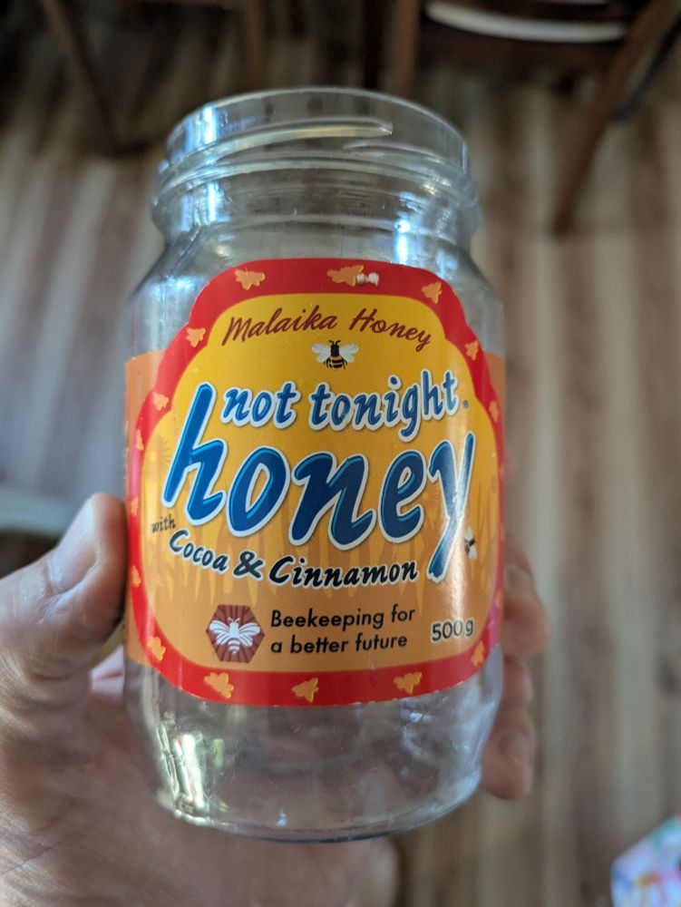
Such incredible branding.
My favorite 🍯 from Uganda.
My favorite 🍯 from Uganda.
September 8, 2025 at 1:25 PM
Such incredible branding.
My favorite 🍯 from Uganda.
My favorite 🍯 from Uganda.
CVS - this is aggressive

August 1, 2025 at 12:10 AM
CVS - this is aggressive
Found in satellite imagery:
Credit: Mapbox @ (-2.195, 28.084)
Credit: Mapbox @ (-2.195, 28.084)

July 10, 2025 at 3:10 PM
Found in satellite imagery:
Credit: Mapbox @ (-2.195, 28.084)
Credit: Mapbox @ (-2.195, 28.084)
Where in the world is Carmen San Diego?

May 7, 2025 at 10:17 PM
Where in the world is Carmen San Diego?
How I slept after being sick much of the week and my spouse returning from 12 days of travel 😌

May 3, 2025 at 5:43 PM
How I slept after being sick much of the week and my spouse returning from 12 days of travel 😌
Duo is trolling me

April 22, 2025 at 3:59 PM
Duo is trolling me
#gischat
1. WTF is going on with the multi colored states in graduated shades of tan to orange.... oh wait, I know why!
2. Rivers are nearly indistinguishable from the state boundaries... which, giving the benefit of the doubt, makes the above choice in #1 make sense, but it is a bad combo.
1. WTF is going on with the multi colored states in graduated shades of tan to orange.... oh wait, I know why!
2. Rivers are nearly indistinguishable from the state boundaries... which, giving the benefit of the doubt, makes the above choice in #1 make sense, but it is a bad combo.
February 25, 2025 at 2:29 PM
#gischat
1. WTF is going on with the multi colored states in graduated shades of tan to orange.... oh wait, I know why!
2. Rivers are nearly indistinguishable from the state boundaries... which, giving the benefit of the doubt, makes the above choice in #1 make sense, but it is a bad combo.
1. WTF is going on with the multi colored states in graduated shades of tan to orange.... oh wait, I know why!
2. Rivers are nearly indistinguishable from the state boundaries... which, giving the benefit of the doubt, makes the above choice in #1 make sense, but it is a bad combo.
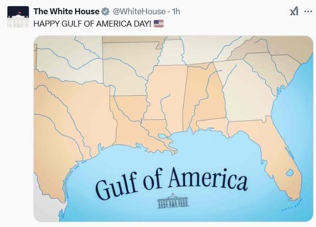
can we talk about the shitty "Gulf of America" map?
www.washingtonpost.com/wp-apps/imrs...
www.washingtonpost.com/wp-apps/imrs...

February 24, 2025 at 5:43 PM
can we talk about the shitty "Gulf of America" map?
www.washingtonpost.com/wp-apps/imrs...
www.washingtonpost.com/wp-apps/imrs...
A better pic of Senator Booker imploring several thousand to stay in the fight. He and Sen Schatz plan to block any State Dept/foreign policy nominees.

February 5, 2025 at 6:43 PM
A better pic of Senator Booker imploring several thousand to stay in the fight. He and Sen Schatz plan to block any State Dept/foreign policy nominees.
Senator Cory Booker speaking at rally in support of #USAID #saveusaid

February 5, 2025 at 5:27 PM
Senator Cory Booker speaking at rally in support of #USAID #saveusaid
Timeline cleanse. This goofy goat (or sheep?) with a massive underbite.

January 27, 2025 at 3:22 PM
Timeline cleanse. This goofy goat (or sheep?) with a massive underbite.
#30daymapchallenge
Day 22 - two color
Canals of Xochimilco in Mexico City
An ancient network of canals built by the Aztec
Day 22 - two color
Canals of Xochimilco in Mexico City
An ancient network of canals built by the Aztec

November 22, 2024 at 10:07 PM
#30daymapchallenge
Day 22 - two color
Canals of Xochimilco in Mexico City
An ancient network of canals built by the Aztec
Day 22 - two color
Canals of Xochimilco in Mexico City
An ancient network of canals built by the Aztec
and now you're at Dreamliner status (787)

November 22, 2024 at 8:48 PM
and now you're at Dreamliner status (787)
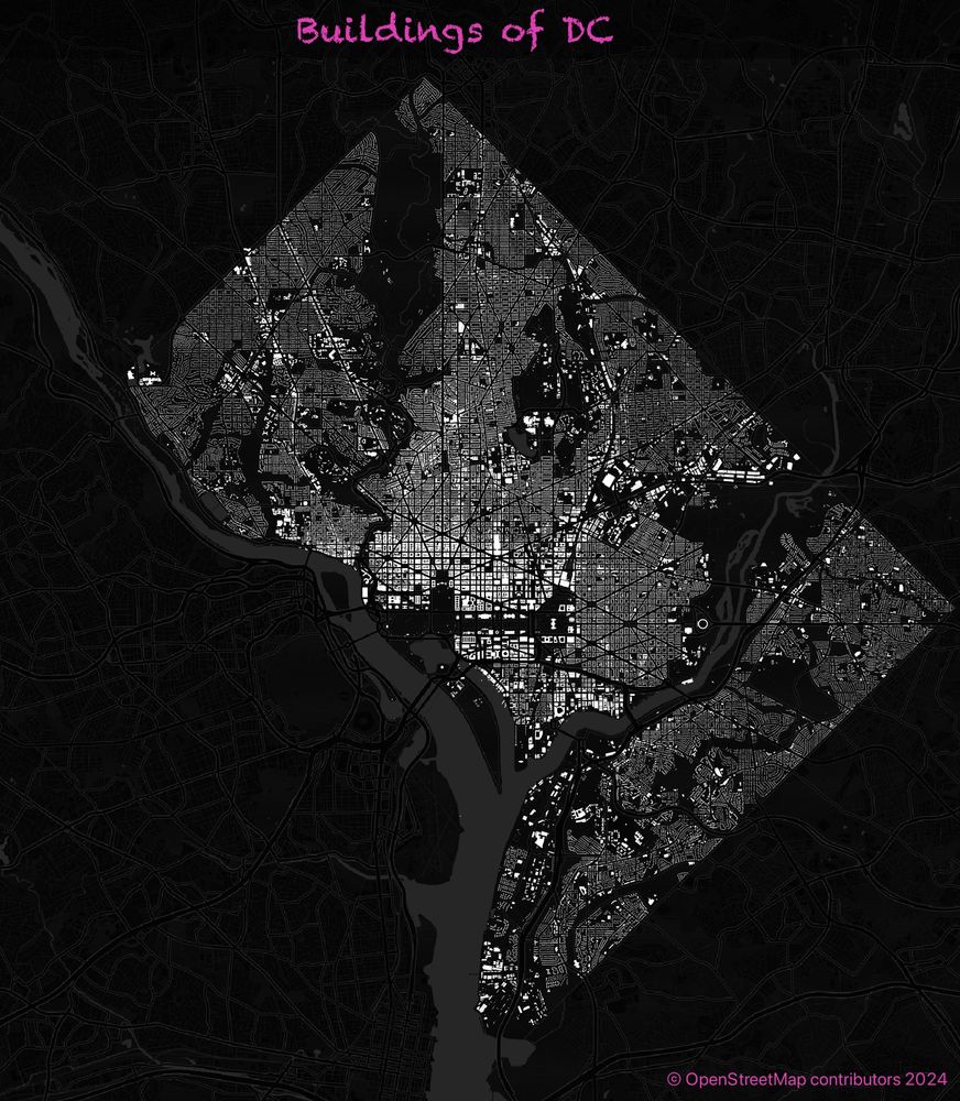
An alternate if you're digging the pink

November 20, 2024 at 10:55 PM
An alternate if you're digging the pink
November 20, 2024 at 10:47 PM

November 1, 2024 at 5:55 PM
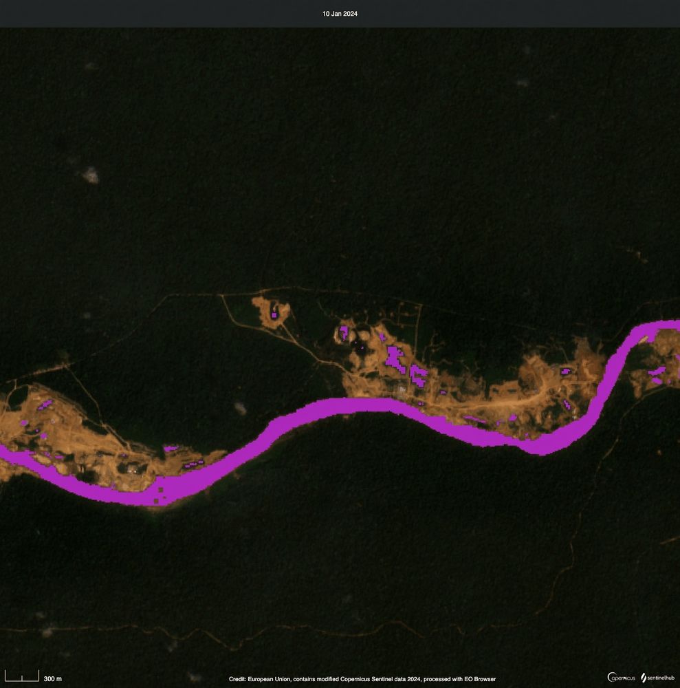
initial experiment on detecting tailing ponds (along a river) #earthobservation

October 15, 2024 at 4:33 PM
initial experiment on detecting tailing ponds (along a river) #earthobservation
workin' it on this Friday

October 11, 2024 at 9:06 PM
workin' it on this Friday
Bluesky now has over 10 million users, and I was #2,035,735!

September 20, 2024 at 4:46 PM
Bluesky now has over 10 million users, and I was #2,035,735!
I'm pointing at the "Prefident's Home" - perhaps that's a clue to the map's origins.

December 15, 2023 at 9:11 PM
I'm pointing at the "Prefident's Home" - perhaps that's a clue to the map's origins.
I loved to see this historic DC map painted as a mural at the View of DC in Rosslyn. I wonder if any #carto / history buffs can I identify the original map?

December 15, 2023 at 9:10 PM
I loved to see this historic DC map painted as a mural at the View of DC in Rosslyn. I wonder if any #carto / history buffs can I identify the original map?