


Erik
@eriklowe.bsky.social
Co-Executive Director at SpokaneReimagined.org.
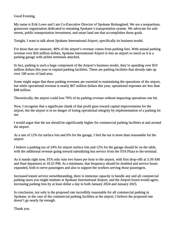
My comments for tonight's city council meeting regarding the proposed commercial parking tax.
It will be interesting to see if the council is able to pass this measure despite the overwhelming amount of pushback from Spokane's parking lot operators and reactionary business community.
It will be interesting to see if the council is able to pass this measure despite the overwhelming amount of pushback from Spokane's parking lot operators and reactionary business community.

November 25, 2025 at 12:02 AM
My comments for tonight's city council meeting regarding the proposed commercial parking tax.
It will be interesting to see if the council is able to pass this measure despite the overwhelming amount of pushback from Spokane's parking lot operators and reactionary business community.
It will be interesting to see if the council is able to pass this measure despite the overwhelming amount of pushback from Spokane's parking lot operators and reactionary business community.
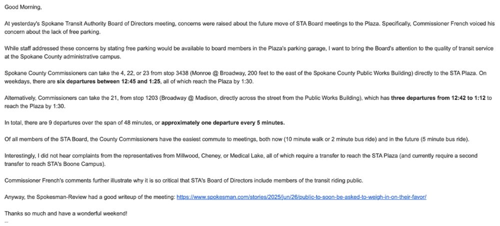
My comments for today's Spokane Transit Authority Board of Directors meeting:

November 20, 2025 at 4:24 PM
My comments for today's Spokane Transit Authority Board of Directors meeting:
It sure is neat to see the impact @spokanereimagined.org has had on the public discourse over the last two years.

November 18, 2025 at 7:24 PM
It sure is neat to see the impact @spokanereimagined.org has had on the public discourse over the last two years.
My comments for tonight’s city council meeting regarding the proposed commercial parking tax.
I sincerely hope the rumors I’ve heard of a delayed vote are incorrect.
I sincerely hope the rumors I’ve heard of a delayed vote are incorrect.
November 17, 2025 at 8:39 PM
My comments for tonight’s city council meeting regarding the proposed commercial parking tax.
I sincerely hope the rumors I’ve heard of a delayed vote are incorrect.
I sincerely hope the rumors I’ve heard of a delayed vote are incorrect.
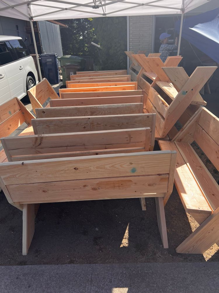
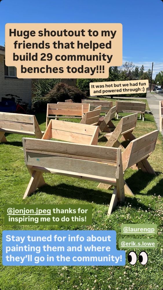
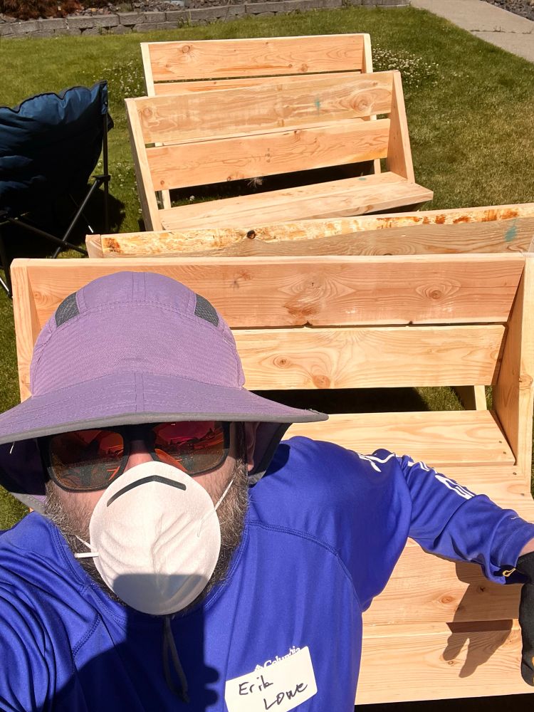
Not a bad day to build some benches.
July 27, 2025 at 1:09 AM
Not a bad day to build some benches.
My comments for today's Spokane Transit Authority Board of Directors meeting:
July 24, 2025 at 6:26 PM
My comments for today's Spokane Transit Authority Board of Directors meeting:
You know a blog is credible when they put a person's legal name in "scare quotes".

July 14, 2025 at 3:26 PM
You know a blog is credible when they put a person's legal name in "scare quotes".
I'm not much for car culture, but I'm a big fan of bumper sticker culture.

July 11, 2025 at 12:34 AM
I'm not much for car culture, but I'm a big fan of bumper sticker culture.
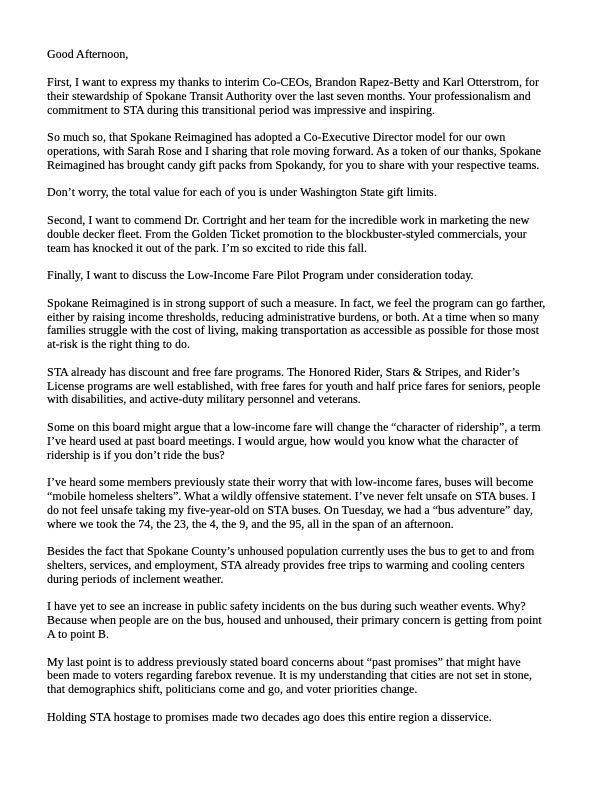
Email I sent this morning to the Spokane Transit Authority Board of Directors:
June 27, 2025 at 4:17 PM
Email I sent this morning to the Spokane Transit Authority Board of Directors:
A few years ago, I had a series of seizures that prevented me from driving for months.
Our existing car-centric infrastructure is way more ableist than opening streets to people.
Our existing car-centric infrastructure is way more ableist than opening streets to people.

June 25, 2025 at 7:05 PM
A few years ago, I had a series of seizures that prevented me from driving for months.
Our existing car-centric infrastructure is way more ableist than opening streets to people.
Our existing car-centric infrastructure is way more ableist than opening streets to people.
I asked Governor Ferguson how the North Spokane Corridor will reduce Vehicle Miles Traveled when multiple speakers discussed the development opportunities it will open north of Spokane. This was the answer I got.
June 9, 2025 at 11:45 PM
I asked Governor Ferguson how the North Spokane Corridor will reduce Vehicle Miles Traveled when multiple speakers discussed the development opportunities it will open north of Spokane. This was the answer I got.

Why do I spend countless hours of my time advocating for better transit?
Because I know what is possible.
Spokane has the potential to be the most livable, vibrant, and innovative city in North America.
Now is the time.
Because I know what is possible.
Spokane has the potential to be the most livable, vibrant, and innovative city in North America.
Now is the time.
May 18, 2025 at 3:58 PM
Why do I spend countless hours of my time advocating for better transit?
Because I know what is possible.
Spokane has the potential to be the most livable, vibrant, and innovative city in North America.
Now is the time.
Because I know what is possible.
Spokane has the potential to be the most livable, vibrant, and innovative city in North America.
Now is the time.
A Spokane Reimagined member took a picture of me yesterday at Bloomsday.

May 5, 2025 at 1:38 PM
A Spokane Reimagined member took a picture of me yesterday at Bloomsday.
This graphic from the Spokesman-Review is a great illustration of what congestion is going to look like when the North Spokane Corridor is finished. We're essentially just shifting downtown congestion to the east, further impacting Spokane's lowest income neighborhoods.

April 14, 2025 at 4:35 PM
This graphic from the Spokesman-Review is a great illustration of what congestion is going to look like when the North Spokane Corridor is finished. We're essentially just shifting downtown congestion to the east, further impacting Spokane's lowest income neighborhoods.
Here are my comments for tomorrow's Spokane Regional Transportation Council board meeting.

April 9, 2025 at 2:30 PM
Here are my comments for tomorrow's Spokane Regional Transportation Council board meeting.

Here are the remaining graphs.
See next slide for link to the spreadsheet.
Please triple check my math! I want to be sure this information is accurate!
See next slide for link to the spreadsheet.
Please triple check my math! I want to be sure this information is accurate!


April 5, 2025 at 3:20 PM
Here are the remaining graphs.
See next slide for link to the spreadsheet.
Please triple check my math! I want to be sure this information is accurate!
See next slide for link to the spreadsheet.
Please triple check my math! I want to be sure this information is accurate!
I'm no finance guy, so it was incredibly helpful for @strongtowns.org to release their municipal finance decoder yesterday.
In the last decade, Spokane has seen its financial position weaken considerably.
See replies for a link to my spreadsheet and additional graphs.
#financedecoder #dothemath
In the last decade, Spokane has seen its financial position weaken considerably.
See replies for a link to my spreadsheet and additional graphs.
#financedecoder #dothemath


April 5, 2025 at 3:15 PM
I'm no finance guy, so it was incredibly helpful for @strongtowns.org to release their municipal finance decoder yesterday.
In the last decade, Spokane has seen its financial position weaken considerably.
See replies for a link to my spreadsheet and additional graphs.
#financedecoder #dothemath
In the last decade, Spokane has seen its financial position weaken considerably.
See replies for a link to my spreadsheet and additional graphs.
#financedecoder #dothemath
These are just pedestrians, scooters and bicycles are not included in my data.
This data isn't exact, as my map includes pedestrian fatalities from 2024 and 2025, but it gives some insight into the questions you asked:
This data isn't exact, as my map includes pedestrian fatalities from 2024 and 2025, but it gives some insight into the questions you asked:

April 3, 2025 at 4:20 PM
These are just pedestrians, scooters and bicycles are not included in my data.
This data isn't exact, as my map includes pedestrian fatalities from 2024 and 2025, but it gives some insight into the questions you asked:
This data isn't exact, as my map includes pedestrian fatalities from 2024 and 2025, but it gives some insight into the questions you asked:
Working on a project to call greater attention to the dangers pedestrians face on Spokane streets.
The most deadly area, by far, is Downtown Spokane. High speed, one way streets are death traps.
The most deadly area, by far, is Downtown Spokane. High speed, one way streets are death traps.
April 3, 2025 at 3:10 PM
Working on a project to call greater attention to the dangers pedestrians face on Spokane streets.
The most deadly area, by far, is Downtown Spokane. High speed, one way streets are death traps.
The most deadly area, by far, is Downtown Spokane. High speed, one way streets are death traps.
Yes, pedestrian fatalities from being struck by an automobile.
Here's a closer view. Most of the streets have been converted to one ways to optimize throughput. The result is very wide streets with speeding vehicle traffic.
Here's a closer view. Most of the streets have been converted to one ways to optimize throughput. The result is very wide streets with speeding vehicle traffic.

April 1, 2025 at 3:46 PM
Yes, pedestrian fatalities from being struck by an automobile.
Here's a closer view. Most of the streets have been converted to one ways to optimize throughput. The result is very wide streets with speeding vehicle traffic.
Here's a closer view. Most of the streets have been converted to one ways to optimize throughput. The result is very wide streets with speeding vehicle traffic.
Spokane County Pedestrian fatalities from 2014-2023 overlaid with census tracts that had 50% or greater households considered "low-income" (200% of the poverty line).

April 1, 2025 at 2:41 PM
Spokane County Pedestrian fatalities from 2014-2023 overlaid with census tracts that had 50% or greater households considered "low-income" (200% of the poverty line).
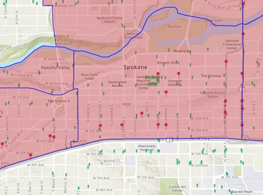
The below map screenshots are STA transit stops and pedestrian fatalities from 2019-2023
Green = Transit Stops
Purple = Fatal Collisions (This data isn't exact, WSDOT has about 10 more fatalities than the SRTC, but SRTC had a readily available dataset from which I could pull shapefiles)
Green = Transit Stops
Purple = Fatal Collisions (This data isn't exact, WSDOT has about 10 more fatalities than the SRTC, but SRTC had a readily available dataset from which I could pull shapefiles)


April 1, 2025 at 2:44 AM
The below map screenshots are STA transit stops and pedestrian fatalities from 2019-2023
Green = Transit Stops
Purple = Fatal Collisions (This data isn't exact, WSDOT has about 10 more fatalities than the SRTC, but SRTC had a readily available dataset from which I could pull shapefiles)
Green = Transit Stops
Purple = Fatal Collisions (This data isn't exact, WSDOT has about 10 more fatalities than the SRTC, but SRTC had a readily available dataset from which I could pull shapefiles)
Working on a little project.

March 26, 2025 at 10:37 PM
Working on a little project.