


Eric Holthaus
@ericholthaus.com
Meteorologist & climate journalist. Dad. Birder. Minnesotan. Optimistic to a fault.
Science news with attitude for The Guardian. Author of The Future Earth.
Contact me securely on Signal: 3162958947
Science news with attitude for The Guardian. Author of The Future Earth.
Contact me securely on Signal: 3162958947
There has never been this little sea ice in the Arctic during December.
We are in a climate emergency.
(graphic by @zacklabe.com)
We are in a climate emergency.
(graphic by @zacklabe.com)

December 5, 2025 at 2:24 PM
There has never been this little sea ice in the Arctic during December.
We are in a climate emergency.
(graphic by @zacklabe.com)
We are in a climate emergency.
(graphic by @zacklabe.com)
Move over, Spotify... my @inaturalist.bsky.social year in review is here!
www.inaturalist.org/stats/2025/e...
www.inaturalist.org/stats/2025/e...


November 26, 2025 at 6:31 AM
Move over, Spotify... my @inaturalist.bsky.social year in review is here!
www.inaturalist.org/stats/2025/e...
www.inaturalist.org/stats/2025/e...
Twin Cities aurora tonight is directly overhead and in overdrive!

November 12, 2025 at 4:02 AM
Twin Cities aurora tonight is directly overhead and in overdrive!

Update: Hurricane Melissa has made landfall in southwestern Jamaica — and has tied the all-time record for strongest Atlantic basin hurricane landfall.
Hurricane Melissa will be a generational-scale climate disaster and will require an international response to help Jamaicans recover.
Hurricane Melissa will be a generational-scale climate disaster and will require an international response to help Jamaicans recover.

October 28, 2025 at 5:09 PM
Update: Hurricane Melissa has made landfall in southwestern Jamaica — and has tied the all-time record for strongest Atlantic basin hurricane landfall.
Hurricane Melissa will be a generational-scale climate disaster and will require an international response to help Jamaicans recover.
Hurricane Melissa will be a generational-scale climate disaster and will require an international response to help Jamaicans recover.
Hurricane Melissa will make landfall in Jamaica in a few hours as one of the two strongest hurricanes ever to make landfall anywhere in the Atlantic Basin -- on par with the 1935 Labor Day hurricane in south Florida.
Just horrific. The stuff of nightmares.
Just horrific. The stuff of nightmares.
October 28, 2025 at 1:48 PM
Hurricane Melissa will make landfall in Jamaica in a few hours as one of the two strongest hurricanes ever to make landfall anywhere in the Atlantic Basin -- on par with the 1935 Labor Day hurricane in south Florida.
Just horrific. The stuff of nightmares.
Just horrific. The stuff of nightmares.

October 28, 2025 at 4:21 AM
...aaaand Melissa is now the strongest tropical cyclone ever measured in the satellite era.
T8.5 = 185kt
T8.5 = 185kt

October 28, 2025 at 4:10 AM
...aaaand Melissa is now the strongest tropical cyclone ever measured in the satellite era.
T8.5 = 185kt
T8.5 = 185kt
...aaaand Melissa has just tied Hurricane Patricia for the most intense tropical cyclone ever measured by satellite, anywhere in the world.
T8.4 = 182kt
Here's the global top-10 list of the satellite era (from Velden 2017):
T8.4 = 182kt
Here's the global top-10 list of the satellite era (from Velden 2017):


October 28, 2025 at 3:43 AM
...aaaand Melissa has just tied Hurricane Patricia for the most intense tropical cyclone ever measured by satellite, anywhere in the world.
T8.4 = 182kt
Here's the global top-10 list of the satellite era (from Velden 2017):
T8.4 = 182kt
Here's the global top-10 list of the satellite era (from Velden 2017):
Super Typhoon Haiyan (2013) is exactly the storm I'd compare Melissa to. It was the only other time I've seen the Dvorak scale violated above 8.0, and the only other time I've seen a complete ring of -80°F cloud tops (shown here in pink).

October 28, 2025 at 1:51 AM
Super Typhoon Haiyan (2013) is exactly the storm I'd compare Melissa to. It was the only other time I've seen the Dvorak scale violated above 8.0, and the only other time I've seen a complete ring of -80°F cloud tops (shown here in pink).
Over the past 24 hours, the forecast for Jamaica has become even more ominous.
Hurricane Melissa is now expected to make landfall at Category 5 strength — with more than 1 meter of rainfall.
Melissa will be as bad as Hurricane Gilbert (1988). It could take years for the country to recover.
Hurricane Melissa is now expected to make landfall at Category 5 strength — with more than 1 meter of rainfall.
Melissa will be as bad as Hurricane Gilbert (1988). It could take years for the country to recover.

October 25, 2025 at 9:44 PM
Over the past 24 hours, the forecast for Jamaica has become even more ominous.
Hurricane Melissa is now expected to make landfall at Category 5 strength — with more than 1 meter of rainfall.
Melissa will be as bad as Hurricane Gilbert (1988). It could take years for the country to recover.
Hurricane Melissa is now expected to make landfall at Category 5 strength — with more than 1 meter of rainfall.
Melissa will be as bad as Hurricane Gilbert (1988). It could take years for the country to recover.
Looks like Minneapolis hit 90°F today, October 4th — the latest 90-degree day in city history.

October 4, 2025 at 10:36 PM
Looks like Minneapolis hit 90°F today, October 4th — the latest 90-degree day in city history.
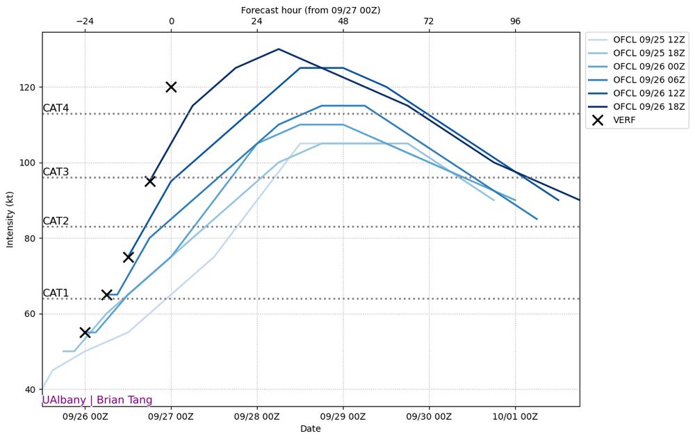
This is just about as perfect a hurricane as you'll ever see in the Atlantic.
Category 5 Humberto:
Category 5 Humberto:
September 27, 2025 at 10:00 PM
This is just about as perfect a hurricane as you'll ever see in the Atlantic.
Category 5 Humberto:
Category 5 Humberto:
It looks like Humberto is now a Category 4 hurricane. Even earlier this morning, the NHC didn't expect Hurricane Humberto to reach Category 4 until Monday.
That means all 3 hurricanes so far in 2025 have reached Cat 4 or higher — that's never happened before.
That means all 3 hurricanes so far in 2025 have reached Cat 4 or higher — that's never happened before.
September 27, 2025 at 2:03 AM
It looks like Humberto is now a Category 4 hurricane. Even earlier this morning, the NHC didn't expect Hurricane Humberto to reach Category 4 until Monday.
That means all 3 hurricanes so far in 2025 have reached Cat 4 or higher — that's never happened before.
That means all 3 hurricanes so far in 2025 have reached Cat 4 or higher — that's never happened before.
Before Gabrielle, there has been just one instance of a Category 4+ hurricane traveling north of 34°N since Atlantic records begin in 1851.
Hurricane Ella (1978):
Hurricane Ella (1978):

September 23, 2025 at 2:10 PM
Before Gabrielle, there has been just one instance of a Category 4+ hurricane traveling north of 34°N since Atlantic records begin in 1851.
Hurricane Ella (1978):
Hurricane Ella (1978):
Today, Hurricane Gabrielle strengthened from a Category 1 to a mid-Category 4 — more quickly than even the most aggressive weather models predicted.
It's almost like something about the weather has... changed.
It's almost like something about the weather has... changed.

September 23, 2025 at 2:14 AM
Today, Hurricane Gabrielle strengthened from a Category 1 to a mid-Category 4 — more quickly than even the most aggressive weather models predicted.
It's almost like something about the weather has... changed.
It's almost like something about the weather has... changed.
our 16-year-old just explained that her new aesthetic is crittercore. i could get behind this.
www.pinterest.com/lefpaints/cr...
www.pinterest.com/lefpaints/cr...

September 17, 2025 at 7:13 PM
our 16-year-old just explained that her new aesthetic is crittercore. i could get behind this.
www.pinterest.com/lefpaints/cr...
www.pinterest.com/lefpaints/cr...
My honest opinion is that Hawaii doesn't have much to worry about with Kiko.
The forecast trend is for the storm to be moving further and further away from the islands, and it should be weakening by the time it gets close.
Expect some heavy surf and rain showers, but that's about it.
The forecast trend is for the storm to be moving further and further away from the islands, and it should be weakening by the time it gets close.
Expect some heavy surf and rain showers, but that's about it.


September 6, 2025 at 3:02 PM
My honest opinion is that Hawaii doesn't have much to worry about with Kiko.
The forecast trend is for the storm to be moving further and further away from the islands, and it should be weakening by the time it gets close.
Expect some heavy surf and rain showers, but that's about it.
The forecast trend is for the storm to be moving further and further away from the islands, and it should be weakening by the time it gets close.
Expect some heavy surf and rain showers, but that's about it.
Update: They took the book down.
And also added one of my favorite climate books ever: Not Too Late by @rebeccasolnit.bsky.social and @thelmayoung.bsky.social ❤️
And also added one of my favorite climate books ever: Not Too Late by @rebeccasolnit.bsky.social and @thelmayoung.bsky.social ❤️

September 5, 2025 at 4:26 PM
Update: They took the book down.
And also added one of my favorite climate books ever: Not Too Late by @rebeccasolnit.bsky.social and @thelmayoung.bsky.social ❤️
And also added one of my favorite climate books ever: Not Too Late by @rebeccasolnit.bsky.social and @thelmayoung.bsky.social ❤️
Welp, it's definitely wildfire season.

September 4, 2025 at 2:12 AM
Welp, it's definitely wildfire season.
I found an answer in your paper, lol. Great work. This is a really interesting study.

August 29, 2025 at 1:03 PM
I found an answer in your paper, lol. Great work. This is a really interesting study.
Hey @hclib.bsky.social, just flagging that you're (unintentionally?) featuring a notorious climate change denier's book in this "Think Green" display at Pierre Bottineau library.
I'm all for free speech but Shellenberger has spent his career undermining the good work this display is trying to do.
I'm all for free speech but Shellenberger has spent his career undermining the good work this display is trying to do.

August 26, 2025 at 3:37 PM
Hey @hclib.bsky.social, just flagging that you're (unintentionally?) featuring a notorious climate change denier's book in this "Think Green" display at Pierre Bottineau library.
I'm all for free speech but Shellenberger has spent his career undermining the good work this display is trying to do.
I'm all for free speech but Shellenberger has spent his career undermining the good work this display is trying to do.
Check out the incredible lightning storm over northeast Iowa that my 8 year old recorded this weekend!
August 18, 2025 at 11:33 PM
Check out the incredible lightning storm over northeast Iowa that my 8 year old recorded this weekend!
Erin is a large and powerful hurricane.
Even though Erin's center will remain well offshore, there could be gusty winds and damaging waves along the NC Outer Banks, Delmarva, Long Island, and Massachusetts coast and islands this week.
Even though Erin's center will remain well offshore, there could be gusty winds and damaging waves along the NC Outer Banks, Delmarva, Long Island, and Massachusetts coast and islands this week.

August 18, 2025 at 3:55 PM
Erin is a large and powerful hurricane.
Even though Erin's center will remain well offshore, there could be gusty winds and damaging waves along the NC Outer Banks, Delmarva, Long Island, and Massachusetts coast and islands this week.
Even though Erin's center will remain well offshore, there could be gusty winds and damaging waves along the NC Outer Banks, Delmarva, Long Island, and Massachusetts coast and islands this week.
NHC now expects Hurricane Erin to reach Category 4 in the open seas of the western Atlantic — again, this storm is virtually no threat to land.
Somewhere between a 40-60% chance of rapid intensification in the next day or two.
Somewhere between a 40-60% chance of rapid intensification in the next day or two.

August 15, 2025 at 10:54 PM
NHC now expects Hurricane Erin to reach Category 4 in the open seas of the western Atlantic — again, this storm is virtually no threat to land.
Somewhere between a 40-60% chance of rapid intensification in the next day or two.
Somewhere between a 40-60% chance of rapid intensification in the next day or two.