


Dustin Mulvaney
@dustinmulvaney.bsky.social
Professor, Environmental Studies🌎
San José State University @CalState.Bsky.social
Fellow, Payne Institute @ Colorado School of Mines, Climate & Community Institute @cplusc.bsky.social, Switzer Network. www.dustinmulvaney.com
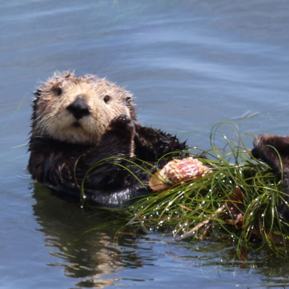
📍Popeloutchom, Monterey Bay 🌅🦦
San José State University @CalState.Bsky.social
Fellow, Payne Institute @ Colorado School of Mines, Climate & Community Institute @cplusc.bsky.social, Switzer Network. www.dustinmulvaney.com
📍Popeloutchom, Monterey Bay 🌅🦦
California’s getting soaked, but there’s still a wildfire across the Sierra Nevada with mandatory evacuations. My friend’s parents live just off Hwy 395 by Crowley Lake pictured below, right at the fire’s edge. 📸: CalFire

November 14, 2025 at 7:45 AM
California’s getting soaked, but there’s still a wildfire across the Sierra Nevada with mandatory evacuations. My friend’s parents live just off Hwy 395 by Crowley Lake pictured below, right at the fire’s edge. 📸: CalFire


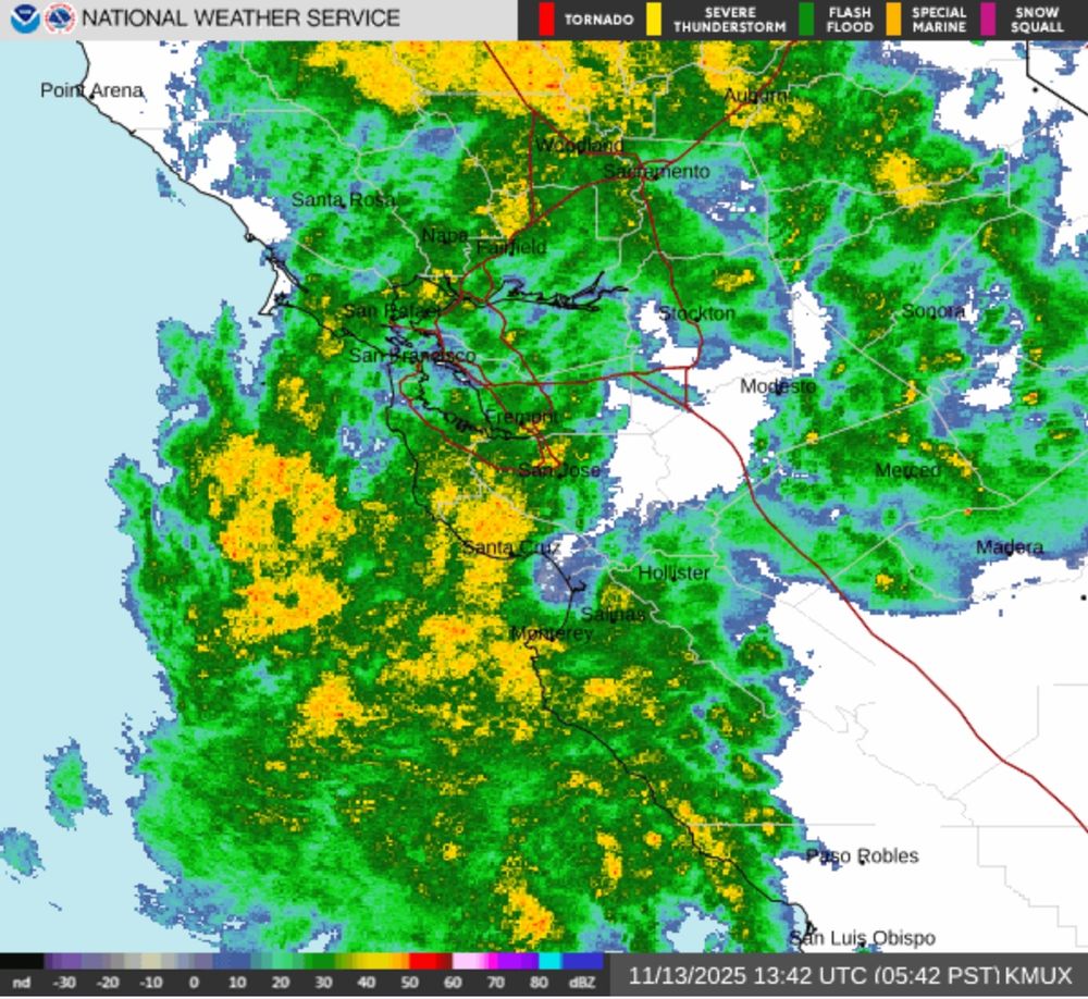
This atmospheric river delivered about a full November’s worth of rain. We were already running well above average for the water year, and today’s totals push Santa Cruz to roughly 257% of normal. A few really high totals at the coastal peaks like Ben Lomond Mountain too. #CAwx #CAwater


November 14, 2025 at 6:17 AM
Storm clouds gather over Monterey Bay as last night’s stalled atmospheric river loomed offshore, ahead of today’s soaking rain.

November 14, 2025 at 3:23 AM
Storm clouds gather over Monterey Bay as last night’s stalled atmospheric river loomed offshore, ahead of today’s soaking rain.

November 14, 2025 at 3:16 AM
Over 5 inches of rain on top of Ben Lomond Mountain in past 24 hours, no doubt getting an assist from the mountain orography, still raining. ☔️🌧️🌧️ #CAwx #AtmosphericRiver

November 14, 2025 at 2:16 AM
Over 5 inches of rain on top of Ben Lomond Mountain in past 24 hours, no doubt getting an assist from the mountain orography, still raining. ☔️🌧️🌧️ #CAwx #AtmosphericRiver
Behold the atmospheric river rolling into California today.. a firehose of moisture wrapped into the rotation of an extratropical cyclone. 🌀🌧️🌧️🌧️
November 13, 2025 at 10:30 PM
Behold the atmospheric river rolling into California today.. a firehose of moisture wrapped into the rotation of an extratropical cyclone. 🌀🌧️🌧️🌧️
Storm clouds gather over Monterey Bay, Moss Landing stacks and Salinas Valley lights, out on the horizon.

November 13, 2025 at 2:36 PM
Storm clouds gather over Monterey Bay, Moss Landing stacks and Salinas Valley lights, out on the horizon.
Storm front stalled on Monterey Bay last night.. real lens versus iPhone camera.

November 13, 2025 at 2:18 PM
Storm front stalled on Monterey Bay last night.. real lens versus iPhone camera.
Well, this is gonna be fun getting the kids to school. #AtmosphericRiver #CAwx
November 13, 2025 at 1:54 PM
Well, this is gonna be fun getting the kids to school. #AtmosphericRiver #CAwx
Monterey Canyon has a steeper dropoff than the Grand Canyon!

November 13, 2025 at 6:07 AM
Monterey Canyon has a steeper dropoff than the Grand Canyon!
Monterey Bay nightscene.

November 13, 2025 at 5:04 AM
Monterey Bay nightscene.
Given that nearly all of Santa Cruz county was covered in dense fog except a few peaks sticking out like islands in the sky, these might be some of the only photos from last night’s aurora storm around here. #auroraborealis

November 13, 2025 at 1:16 AM
Given that nearly all of Santa Cruz county was covered in dense fog except a few peaks sticking out like islands in the sky, these might be some of the only photos from last night’s aurora storm around here. #auroraborealis
Eagle rock ALERT cam tonight, Santa Cruz Mountains, the aurora substorm burst of activity happened between about 8:30 and 9:30.. fog rolled in at 9:40.
November 12, 2025 at 8:24 AM
Eagle rock ALERT cam tonight, Santa Cruz Mountains, the aurora substorm burst of activity happened between about 8:30 and 9:30.. fog rolled in at 9:40.
This is what the Eagle Rock camera looks like now. Caught the Aurora only moments before it was eaten by the fog.
🌫️🌫️🌫️🌫️🌫️🌫️🌫️🌫️🌫️🌫️🌫️🌫️🌫️
#auroraborealis #stratus
🌫️🌫️🌫️🌫️🌫️🌫️🌫️🌫️🌫️🌫️🌫️🌫️🌫️
#auroraborealis #stratus


November 12, 2025 at 7:53 AM
This is what the Eagle Rock camera looks like now. Caught the Aurora only moments before it was eaten by the fog.
🌫️🌫️🌫️🌫️🌫️🌫️🌫️🌫️🌫️🌫️🌫️🌫️🌫️
#auroraborealis #stratus
🌫️🌫️🌫️🌫️🌫️🌫️🌫️🌫️🌫️🌫️🌫️🌫️🌫️
#auroraborealis #stratus
Aurora borealis above the fog, at the top of Ben Lomond Mountain, Santa Cruz Mountains. #auroraborealis

November 12, 2025 at 7:06 AM
Aurora borealis above the fog, at the top of Ben Lomond Mountain, Santa Cruz Mountains. #auroraborealis
Aurora borealis over Eagle rock, Santa Cruz Mountains. #AuroraWatch

November 12, 2025 at 6:45 AM
Aurora borealis over Eagle rock, Santa Cruz Mountains. #AuroraWatch
Hmmmm. Eagle rock, Santa Cruz Mountains.. that looks like aurora borealis.

November 12, 2025 at 5:43 AM
Hmmmm. Eagle rock, Santa Cruz Mountains.. that looks like aurora borealis.
Truly spectacular aurora colors over the Salton Sea, from imperial irrigation district’s west shore cam looking towards Joshua Tree National Park and Chuckwalla National Monument. #AuroraWatch #SaltonSea
November 12, 2025 at 4:45 AM
Truly spectacular aurora colors over the Salton Sea, from imperial irrigation district’s west shore cam looking towards Joshua Tree National Park and Chuckwalla National Monument. #AuroraWatch #SaltonSea
Imperial Irrigation District’s camera on the Salton Sea near Niland, California, exploding with Aurora color.
November 12, 2025 at 4:08 AM
Imperial Irrigation District’s camera on the Salton Sea near Niland, California, exploding with Aurora color.
Aurora in the Sierra foothills! This is Willow Creek’s ALERT camera, a bit south east of Sacramento. #AuroraWatch cameras.alertcalifornia.org?pos=38.7069_...

November 12, 2025 at 3:32 AM
Aurora in the Sierra foothills! This is Willow Creek’s ALERT camera, a bit south east of Sacramento. #AuroraWatch cameras.alertcalifornia.org?pos=38.7069_...
Orographic lift is how terrain can cause rainfall in the Santa Cruz Mountains. When moist air rises up a mountain slope, it expands causing it to cool adiabatically. Cool air can’t hold as much moisture, so water vapor condenses, forming clouds, fog, and rain; the reverse of adiabatic compression.🧪
November 12, 2025 at 3:01 AM
Orographic lift is how terrain can cause rainfall in the Santa Cruz Mountains. When moist air rises up a mountain slope, it expands causing it to cool adiabatically. Cool air can’t hold as much moisture, so water vapor condenses, forming clouds, fog, and rain; the reverse of adiabatic compression.🧪