


Aaron Zuspan
@aazuspan.dev
🛰️🌲🔥 Researcher at Oregon State University / Earth observation and fire / open source geospatial / Python / Earth Engine
aazuspan.dev
aazuspan.dev
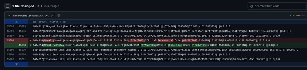
I made a Github repository a few days ago to automatically track changes to the GNIS database of place names in the US.
Apparently it works.
#Denali
Apparently it works.
#Denali
February 21, 2025 at 12:28 AM
I made a Github repository a few days ago to automatically track changes to the GNIS database of place names in the US.
Apparently it works.
#Denali
Apparently it works.
#Denali
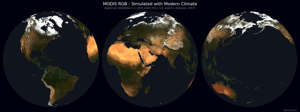
The model is a stupidly simple pixel-based random forest trained with a grid of sampled points (below) using downscaled bioclimatic predictors derived from temp and precip (via WorldClim) and stretched MODIS RGB.
I also tried predicting in HSV and LAB space, but RGB looked the best 🤷♂️
I also tried predicting in HSV and LAB space, but RGB looked the best 🤷♂️

December 8, 2024 at 8:15 PM
The model is a stupidly simple pixel-based random forest trained with a grid of sampled points (below) using downscaled bioclimatic predictors derived from temp and precip (via WorldClim) and stretched MODIS RGB.
I also tried predicting in HSV and LAB space, but RGB looked the best 🤷♂️
I also tried predicting in HSV and LAB space, but RGB looked the best 🤷♂️
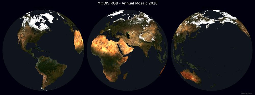
For comparison, here's the actual and predicted modern imagery from MODIS. A climate-only model definitely misses some topographic and soil detail, but seems to capture land cover surprisingly well.
December 8, 2024 at 8:15 PM
For comparison, here's the actual and predicted modern imagery from MODIS. A climate-only model definitely misses some topographic and soil detail, but seems to capture land cover surprisingly well.
Am I too late for #30DayMapChallenge Day 14 - A World Map?
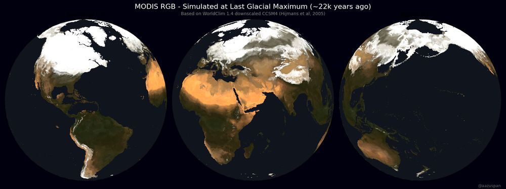
I trained a model to predict MODIS RGB imagery from modern climate and applied it to modeled paleoclimate data to simulate a 22,000 year old satellite image of Earth
I trained a model to predict MODIS RGB imagery from modern climate and applied it to modeled paleoclimate data to simulate a 22,000 year old satellite image of Earth
December 8, 2024 at 8:15 PM
Am I too late for #30DayMapChallenge Day 14 - A World Map?
I trained a model to predict MODIS RGB imagery from modern climate and applied it to modeled paleoclimate data to simulate a 22,000 year old satellite image of Earth
I trained a model to predict MODIS RGB imagery from modern climate and applied it to modeled paleoclimate data to simulate a 22,000 year old satellite image of Earth
#30DayMapChallenge, Day 12: Time and Space
51 years and 11 million #Landsat scenes, showing global cloud-free (<20%) coverage by path and row since Landsat 1 🛰️
51 years and 11 million #Landsat scenes, showing global cloud-free (<20%) coverage by path and row since Landsat 1 🛰️
November 13, 2024 at 1:28 AM
#30DayMapChallenge, Day 12: Time and Space
51 years and 11 million #Landsat scenes, showing global cloud-free (<20%) coverage by path and row since Landsat 1 🛰️
51 years and 11 million #Landsat scenes, showing global cloud-free (<20%) coverage by path and row since Landsat 1 🛰️
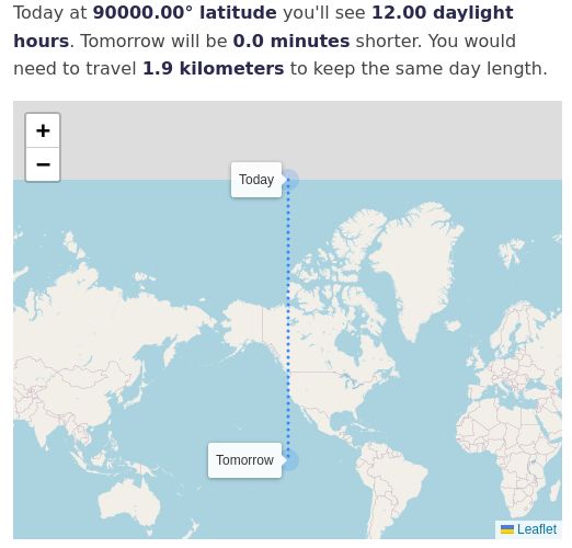
Fun fact, I did zero input validation 👍
November 10, 2024 at 6:56 AM
Fun fact, I did zero input validation 👍
Visualizing how daylight hours change through the year depending on your latitude, for a blog post where I tried to figure out how far you'd need to travel to keep the same day length year-round (spoiler: not very far at first, then REALLY far at each equinox)
www.aazuspan.dev/blog/chasing...
www.aazuspan.dev/blog/chasing...
November 10, 2024 at 6:56 AM
Visualizing how daylight hours change through the year depending on your latitude, for a blog post where I tried to figure out how far you'd need to travel to keep the same day length year-round (spoiler: not very far at first, then REALLY far at each equinox)
www.aazuspan.dev/blog/chasing...
www.aazuspan.dev/blog/chasing...