


Tyler Stanfield
@tylerjstanfield.bsky.social
Oklahoma & Virginia Tech alum | Specialized in GIS, tropical meteorology, and climate teleconnections.
Overlooking Pearl River near Bogalusa, LA @vincentledvina.bsky.social


November 12, 2025 at 4:50 AM
Overlooking Pearl River near Bogalusa, LA @vincentledvina.bsky.social
West of Lumberton, MS

November 12, 2025 at 3:21 AM
West of Lumberton, MS
Brief glimpse of aurora on the horizon in Slidell, LA @vincentledvina.bsky.social
November 12, 2025 at 1:58 AM
Brief glimpse of aurora on the horizon in Slidell, LA @vincentledvina.bsky.social
Reposted by Tyler Stanfield
Regarding the sonde from yesterday morning with the 219-kt spot wind, highest dropsonde wind ever seen in a TC, AOML/HRD shared the raw data and I took a look this morning. They’ll have the final call, but I see nothing wrong with the ob and I suspect it’s going to hold up.

October 29, 2025 at 5:54 PM
Regarding the sonde from yesterday morning with the 219-kt spot wind, highest dropsonde wind ever seen in a TC, AOML/HRD shared the raw data and I took a look this morning. They’ll have the final call, but I see nothing wrong with the ob and I suspect it’s going to hold up.
Reposted by Tyler Stanfield

“Everyone wants more warning time, and that’s why we’re working to upgrade the technology that’s been neglected for far too long to make sure families have as much advance notice as possible,” Noem said. The reality: Closing NOAA labs like NSSL, critical for flash flood forecasts & research.

July 7, 2025 at 3:48 PM
“Everyone wants more warning time, and that’s why we’re working to upgrade the technology that’s been neglected for far too long to make sure families have as much advance notice as possible,” Noem said. The reality: Closing NOAA labs like NSSL, critical for flash flood forecasts & research.
Reposted by Tyler Stanfield
One of the primary tools we use to predict flash floods is the NSSL's Multi-Radar/Multi-Sensor System. "I’ve zero doubt NWS forecasters were leveraging that tool that evening to issue flash flood warnings. NSSL and associated projects are slated for elimination in NOAA’s proposed 2026 budget."

It's been a terrible and tragic weekend from tropically-infused floods, including the heartbreaking events in Texas Hill Country. In today's newsletter, I revisit the weather causes and detail how National Weather Servive forecasters performed admirably despite political headwinds. ⬇️

Trying to Make Sense of the Unspeakable Texas Tragedy
Catastrophic flooding in the Texas Hill Country over the holiday weekend is one of the deadliest in modern memory. How did it happen?
michaelrlowry.substack.com
July 7, 2025 at 2:11 PM
One of the primary tools we use to predict flash floods is the NSSL's Multi-Radar/Multi-Sensor System. "I’ve zero doubt NWS forecasters were leveraging that tool that evening to issue flash flood warnings. NSSL and associated projects are slated for elimination in NOAA’s proposed 2026 budget."
This is the most sinking motion (+VP200) observed over Africa in AMJ since 2015.
MJO phase 5-7 has been favored recently which is a mixed bag for subseasonal TC favorability of the Atlantic.
SW Atlantic & subtropics appear to be the hot spots for TCs generally.
Plots: @webberweather.bsky.social
MJO phase 5-7 has been favored recently which is a mixed bag for subseasonal TC favorability of the Atlantic.
SW Atlantic & subtropics appear to be the hot spots for TCs generally.
Plots: @webberweather.bsky.social


July 7, 2025 at 3:35 PM
This is the most sinking motion (+VP200) observed over Africa in AMJ since 2015.
MJO phase 5-7 has been favored recently which is a mixed bag for subseasonal TC favorability of the Atlantic.
SW Atlantic & subtropics appear to be the hot spots for TCs generally.
Plots: @webberweather.bsky.social
MJO phase 5-7 has been favored recently which is a mixed bag for subseasonal TC favorability of the Atlantic.
SW Atlantic & subtropics appear to be the hot spots for TCs generally.
Plots: @webberweather.bsky.social
90-day avg VP200 anomalies since April show how forcing aloft has evolved from spring into summer.
🟢 Rising motion over west Africa has waned
🟤 Sinking motion has increased over West IO (-IOD)
🟢 Rising has increased over maritime continent (-ENSO)
🟤 Sinking has increased over the Amazon
🟢 Rising motion over west Africa has waned
🟤 Sinking motion has increased over West IO (-IOD)
🟢 Rising has increased over maritime continent (-ENSO)
🟤 Sinking has increased over the Amazon
July 7, 2025 at 3:30 PM
90-day avg VP200 anomalies since April show how forcing aloft has evolved from spring into summer.
🟢 Rising motion over west Africa has waned
🟤 Sinking motion has increased over West IO (-IOD)
🟢 Rising has increased over maritime continent (-ENSO)
🟤 Sinking has increased over the Amazon
🟢 Rising motion over west Africa has waned
🟤 Sinking motion has increased over West IO (-IOD)
🟢 Rising has increased over maritime continent (-ENSO)
🟤 Sinking has increased over the Amazon
Deep convection east of the center of #Chantal is causing stronger pressure falls which is elongating and pulling the low-level center NE closer to the tilted mid-level center of the storm.
This is how TCs attempt to remedy the negative effects of wind shear and reorganize.
This is how TCs attempt to remedy the negative effects of wind shear and reorganize.

July 5, 2025 at 4:30 PM
Deep convection east of the center of #Chantal is causing stronger pressure falls which is elongating and pulling the low-level center NE closer to the tilted mid-level center of the storm.
This is how TCs attempt to remedy the negative effects of wind shear and reorganize.
This is how TCs attempt to remedy the negative effects of wind shear and reorganize.
TS #Chantal has gradually deepened since the last recon flight yesterday despite being quite lopsided due to SW wind shear.
While the west side is barren, the eastern side will be capable of gusty winds in excess of 50 mph and heavy rainfall as it moves into the Carolinas on Sunday.
While the west side is barren, the eastern side will be capable of gusty winds in excess of 50 mph and heavy rainfall as it moves into the Carolinas on Sunday.
July 5, 2025 at 3:52 PM
TS #Chantal has gradually deepened since the last recon flight yesterday despite being quite lopsided due to SW wind shear.
While the west side is barren, the eastern side will be capable of gusty winds in excess of 50 mph and heavy rainfall as it moves into the Carolinas on Sunday.
While the west side is barren, the eastern side will be capable of gusty winds in excess of 50 mph and heavy rainfall as it moves into the Carolinas on Sunday.
Reposted by Tyler Stanfield
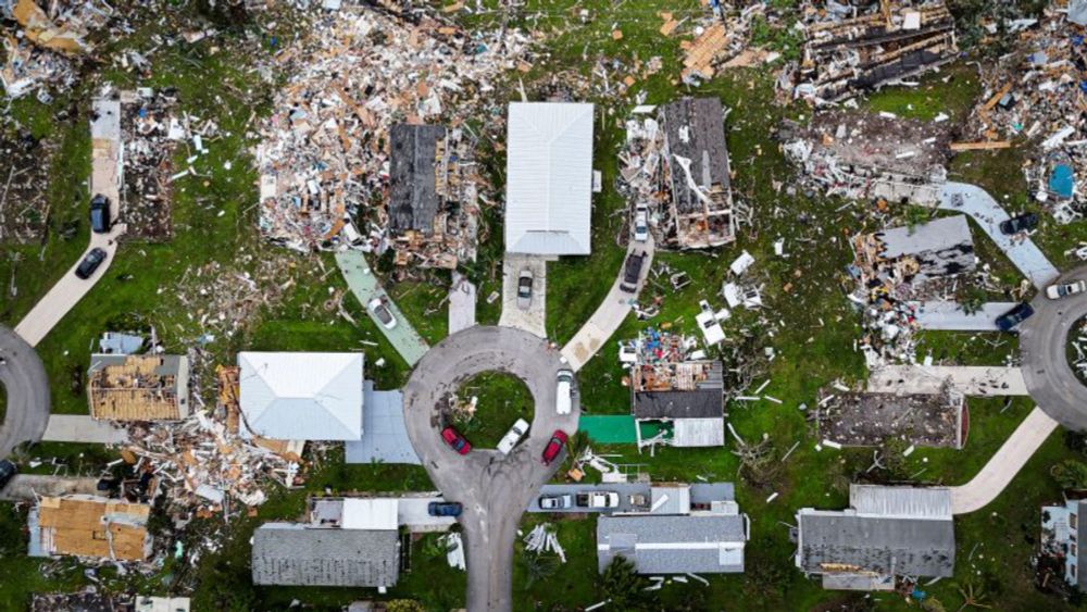
Tragic. Deadliest U.S. flash flood since 39 were killed in Kentucky in July 2022. “A remnant tropical system (Barry), moisture levels in the 99th percentile or higher, forced upward motion due to geography and wind direction, and plentiful instability. That's a recipe for flash flooding.”
I wanted to dig in more to understand the forecasts after the Texas flooding tragedy. Tough one to write knowing what happened.

The latest on TS Chantal today, but more importantly, we take a deep dive into the causes and forecasts leading up to the horrific flooding tragedy in Texas. A lot to unpack today. open.substack.com/pub/theeyewa...
July 5, 2025 at 2:30 PM
Tragic. Deadliest U.S. flash flood since 39 were killed in Kentucky in July 2022. “A remnant tropical system (Barry), moisture levels in the 99th percentile or higher, forced upward motion due to geography and wind direction, and plentiful instability. That's a recipe for flash flooding.”
#Invest92L continues to gradually organize and AF recon has identified a closed surface center on the west edge of the deep convection.
A subtropical or tropical cyclone is forming, and some strengthening could occur before SE US landfall this weekend.
Next 🌀 name is Chantal.
A subtropical or tropical cyclone is forming, and some strengthening could occur before SE US landfall this weekend.
Next 🌀 name is Chantal.
July 4, 2025 at 7:36 PM
#Invest92L continues to gradually organize and AF recon has identified a closed surface center on the west edge of the deep convection.
A subtropical or tropical cyclone is forming, and some strengthening could occur before SE US landfall this weekend.
Next 🌀 name is Chantal.
A subtropical or tropical cyclone is forming, and some strengthening could occur before SE US landfall this weekend.
Next 🌀 name is Chantal.
Reposted by Tyler Stanfield

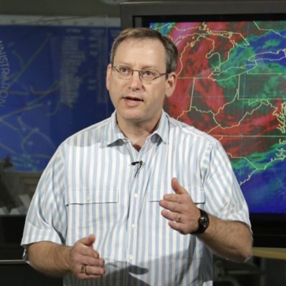
Buckle up for the upcoming peak of the 2025 hurricane season. And possibly for 25 seasons after that. As seen on @nbcmiami.com 📺
#StandUpForScience #ScienceUnderSiege #NOAA #HurricaneSeason #ScienceMatters #TogetherForScience
#StandUpForScience #ScienceUnderSiege #NOAA #HurricaneSeason #ScienceMatters #TogetherForScience
July 4, 2025 at 11:44 AM
Buckle up for the upcoming peak of the 2025 hurricane season. And possibly for 25 seasons after that. As seen on @nbcmiami.com 📺
#StandUpForScience #ScienceUnderSiege #NOAA #HurricaneSeason #ScienceMatters #TogetherForScience
#StandUpForScience #ScienceUnderSiege #NOAA #HurricaneSeason #ScienceMatters #TogetherForScience
Convection continues to become more concentrated and organized on the tail-end of a decaying front, and a broad low is developing as a result.
Despite SW shear, dry air, and limited time over water, a TC could develop over the weekend before impacting the SE US with heavy rain and gusty winds.
Despite SW shear, dry air, and limited time over water, a TC could develop over the weekend before impacting the SE US with heavy rain and gusty winds.
July 4, 2025 at 2:45 PM
Convection continues to become more concentrated and organized on the tail-end of a decaying front, and a broad low is developing as a result.
Despite SW shear, dry air, and limited time over water, a TC could develop over the weekend before impacting the SE US with heavy rain and gusty winds.
Despite SW shear, dry air, and limited time over water, a TC could develop over the weekend before impacting the SE US with heavy rain and gusty winds.
Reposted by Tyler Stanfield

A comprehensive article of what is at stake with the current budget proposed by the DoC ➡️ NOAA.
Nearly every aspect of what we do at NHC has been touched by NOAA Research in one facet or another to our benefit.
#AOML, #CIMSS, #CIRA, #CIMAS all play key roles & losing any of them would be horrific.
Nearly every aspect of what we do at NHC has been touched by NOAA Research in one facet or another to our benefit.
#AOML, #CIMSS, #CIRA, #CIMAS all play key roles & losing any of them would be horrific.
The other day I posted a list of NOAA Research contributions to forecast operations at NHC. I decided to add a little flesh to that list with this Substack post.
franklinjamesl.substack.com/p/hurricane-...
franklinjamesl.substack.com/p/hurricane-...

Hurricane Forecasting and the FY-26 NOAA Budget Proposal
If NOAA were really interested in providing the American public with “gold-standard, cutting-edge data, models, and forecasts”, they wouldn’t be trying to get rid of the people who make it happen.
franklinjamesl.substack.com
July 3, 2025 at 5:43 AM
Global models are gradually coming into better agreement that another shorter-lived TC could develop from the tail-end of a stalling front off the SE CONUS this weekend.
Moderate SW wind shear, dry air, and land interaction will be impediments to development/strengthening of a TC.
Moderate SW wind shear, dry air, and land interaction will be impediments to development/strengthening of a TC.
July 3, 2025 at 3:10 PM
Global models are gradually coming into better agreement that another shorter-lived TC could develop from the tail-end of a stalling front off the SE CONUS this weekend.
Moderate SW wind shear, dry air, and land interaction will be impediments to development/strengthening of a TC.
Moderate SW wind shear, dry air, and land interaction will be impediments to development/strengthening of a TC.
In Bay of Campeche fashion, the curvature of the coast is enhancing sfc vorticity & a small low is developing near the coast under the deep convection.
This weak low will rotate up the wave axis, paralleling the Veracruz coast, buying itself time for TCG.
Next 🌀 name is Barry.
This weak low will rotate up the wave axis, paralleling the Veracruz coast, buying itself time for TCG.
Next 🌀 name is Barry.
June 28, 2025 at 5:46 PM
In Bay of Campeche fashion, the curvature of the coast is enhancing sfc vorticity & a small low is developing near the coast under the deep convection.
This weak low will rotate up the wave axis, paralleling the Veracruz coast, buying itself time for TCG.
Next 🌀 name is Barry.
This weak low will rotate up the wave axis, paralleling the Veracruz coast, buying itself time for TCG.
Next 🌀 name is Barry.
The Atlantic is on the verge of its quietest start since 2014 with 0 storms thus far.
About the only chance for development the next 7 days comes from this lingering trough SE of Bermuda.
Models are latching onto a weak low developing from this convection, but it will struggle to be well-defined.
About the only chance for development the next 7 days comes from this lingering trough SE of Bermuda.
Models are latching onto a weak low developing from this convection, but it will struggle to be well-defined.
June 22, 2025 at 4:08 AM
The Atlantic is on the verge of its quietest start since 2014 with 0 storms thus far.
About the only chance for development the next 7 days comes from this lingering trough SE of Bermuda.
Models are latching onto a weak low developing from this convection, but it will struggle to be well-defined.
About the only chance for development the next 7 days comes from this lingering trough SE of Bermuda.
Models are latching onto a weak low developing from this convection, but it will struggle to be well-defined.
It appears the more active East Pacific has won the CAG tug of war with the Caribbean and a TC will consolidate near Central America in the coming days.
📈 There are some hints of rapid intensification being possible if a more compact TC can form before landfall in Mexico.
The next 🌀 name is Erick.
📈 There are some hints of rapid intensification being possible if a more compact TC can form before landfall in Mexico.
The next 🌀 name is Erick.
June 15, 2025 at 6:50 PM
It appears the more active East Pacific has won the CAG tug of war with the Caribbean and a TC will consolidate near Central America in the coming days.
📈 There are some hints of rapid intensification being possible if a more compact TC can form before landfall in Mexico.
The next 🌀 name is Erick.
📈 There are some hints of rapid intensification being possible if a more compact TC can form before landfall in Mexico.
The next 🌀 name is Erick.
Reposted by Tyler Stanfield

For years, I've long said that climate.gov's team of remarkable communicators (& their amazing blogs, which were accessible but did not "dumb down" the science!) was NOAA's best (& most cost effective!) public-facing extreme #weather / #climate education effort to date. This will be a huge loss.

Climate.gov, a major US government website supporting public education on climate science, will likely shut down after almost all of its staff were fired. What would be worse is if the website were co-opted to publish climate denial content.

Major US climate website likely to be shut down after almost all staff fired
Exclusive: Climate.gov, which supports public education on climate science, will soon no longer publish new content
www.theguardian.com
June 11, 2025 at 3:18 PM
For years, I've long said that climate.gov's team of remarkable communicators (& their amazing blogs, which were accessible but did not "dumb down" the science!) was NOAA's best (& most cost effective!) public-facing extreme #weather / #climate education effort to date. This will be a huge loss.
East Pacific tropics have been active in response to upward motion associated with a CCKW.
This CCKW will soon cross into the Caribbean where it will enhance gyre activity near Central America.
Land interaction will likely impede TC formation, but it remains possible a brief TC forms in 5-7 days.
This CCKW will soon cross into the Caribbean where it will enhance gyre activity near Central America.
Land interaction will likely impede TC formation, but it remains possible a brief TC forms in 5-7 days.
June 11, 2025 at 6:11 PM
East Pacific tropics have been active in response to upward motion associated with a CCKW.
This CCKW will soon cross into the Caribbean where it will enhance gyre activity near Central America.
Land interaction will likely impede TC formation, but it remains possible a brief TC forms in 5-7 days.
This CCKW will soon cross into the Caribbean where it will enhance gyre activity near Central America.
Land interaction will likely impede TC formation, but it remains possible a brief TC forms in 5-7 days.
Reposted by Tyler Stanfield
First you fire the provisional staff, then shove the most experienced out the door, then you try shuffling existing staff into critical vacancies, then you do a new recruitment (for which existing staff will compete, creating new vacancies). Yup, DOGE efficiency at its finest.
SCOOP: The National Weather Service has secured permission to hire about 125 new meteorologists & other specialists as it faces acute staffing shortages in wake of Trump admin. cuts www.cnn.com/2025/06/02/w...

National Weather Service adding around 125 new hires after laying off hundreds | CNN
The new hires would not make up for all the personnel lost in the Trump administration’s cutbacks, but could reduce the number of offices that need to cut back on 24/7 operations.
www.cnn.com
June 2, 2025 at 4:50 PM
First you fire the provisional staff, then shove the most experienced out the door, then you try shuffling existing staff into critical vacancies, then you do a new recruitment (for which existing staff will compete, creating new vacancies). Yup, DOGE efficiency at its finest.
June 1st marks the official start of the 2025 #HurricaneSeason in the North Atlantic.
While I no longer am writing seasonal forecast discussions, I do have some thoughts about the upcoming season.
This season is favored to be near the 1991-2020 avg (14 storms, 7 hurricanes, & 3 major hurricanes).
While I no longer am writing seasonal forecast discussions, I do have some thoughts about the upcoming season.
This season is favored to be near the 1991-2020 avg (14 storms, 7 hurricanes, & 3 major hurricanes).

June 2, 2025 at 12:18 AM
June 1st marks the official start of the 2025 #HurricaneSeason in the North Atlantic.
While I no longer am writing seasonal forecast discussions, I do have some thoughts about the upcoming season.
This season is favored to be near the 1991-2020 avg (14 storms, 7 hurricanes, & 3 major hurricanes).
While I no longer am writing seasonal forecast discussions, I do have some thoughts about the upcoming season.
This season is favored to be near the 1991-2020 avg (14 storms, 7 hurricanes, & 3 major hurricanes).
Reposted by Tyler Stanfield

Literally every single day, United States leadership in scientific research is being tossed in the trash like rotting food and all that power is being ceded to Europe, China, and any other country with a leader that has a brain.

Due to the current gap in funding from the U.S. National Science Foundation (NSF), the NSF Unidata Program is pausing most operations effective 12 May 2025. Nearly all staff will be furloughed until funds from our existing NSF grant become available. For more information, see buff.ly/d2TC1Oy

NSF Unidata Pause in Most Operations
NSF Unidata Pause in Most Operations
www.unidata.ucar.edu
May 9, 2025 at 10:02 PM
Literally every single day, United States leadership in scientific research is being tossed in the trash like rotting food and all that power is being ceded to Europe, China, and any other country with a leader that has a brain.
Reposted by Tyler Stanfield

NEW: NOAA retires its widely cited billion-dollar weather and climate database amid staff cuts. Unique database had been tallying disaster costs for 45 years. www.cnn.com/2025/05/08/c...
NOAA ends extreme weather database that tracked cost of disasters since 1980 | CNN
Its discontinuation is another Trump-administration blow to the public’s view into how fossil fuel pollution is changing the world around them and making extreme weather more costly.
www.cnn.com
May 8, 2025 at 1:38 PM
NEW: NOAA retires its widely cited billion-dollar weather and climate database amid staff cuts. Unique database had been tallying disaster costs for 45 years. www.cnn.com/2025/05/08/c...