Andrew Pritchard
@skydrama.bsky.social
2.3K followers 330 following 1.2K posts
Focused on Disruptive Weather | Award Winning Weather Risk Communicator | Observer of Severe Storms in the American Midwest ⛈️🌪️💨 SKYDRAMA.NET
Posts Media Videos Starter Packs
Pinned
Introducing myself here on 🦋

- Meteorologist born & raised in the American Midwest
- Focused on disruptive weather
- I've won some awards for weather risk communication
- I observed and document severe storms

- Rooting for 🏈🏀 Fighting Illini (local sports team), NIU Huskies (alma mater), ⚾ Cubs
Global ensembles are starting to pick up on another potentially active period across the Central U.S. with more badly needed moisture in the week #2, Oct 24-30 time frame. EPS and ECMWF AIFS are the most gungho, we'll see if GEFS follows.

Track it all at ag-wx.com
Saturday severe weather risk continues to evolve from the Ohio Valley into the Lower/Mid Mississippi Valley, and I'm starting to get higher confidence in a pair of distinct corridors.

Might watch for a fast-moving QLCS with wind/tornado risk north, supercell/tornado risk south.
Champaign-Urbana: Mild temps and a mix of clouds and sunshine through the rest of the work week, with our next chance for rain/storms over the weekend. Read more and have the forecast for C-U sent straight to your inbox every morning here: open.substack.com/pub/chambana...
Daily Weather | Tue, Oct 14th, 2025
Here is your Champaign-Urbana Forecast from Chambana Weather Meteorologist Andrew Pritchard...
open.substack.com
Currently playing in our house as I read this 😂
Flow season returns?

(hashtag not a forecast)
Drought continues to expand/worsen across Illinois. The latest update shows widespread D2 severe drought across central Illinois, with D3 extreme drought across portions of east-central Illinois.
Won’t be there in person, nah. Good luck!
CORN-ADO CHASING! It was another hot, sunny day with record heat in the Midwest, ripe for dust devils. During the harvest season when cornbelt dust devils fill with corn stalks, I call them corn-adoes! Got my drone into a few of them today.
Are June tornadoes disappearing? Are winter tornado outbreaks becoming more common? Examining monthly tornado trends in the U.S. since 1990 with some easy to digest visuals: www.skydrama.net/post/tornado...
Central Illinois/Champaign-Urbana: A stray shower or storm is possible today as we head into another otherwise sunny and hot weekend. Rain chances next week. Read more, subscribe, and have the forecast delivered to your inbox every AM: chambanaweather.substack.com/p/daily-weat...
Daily Weather | Fri, Oct 3rd, 2025
Here is your Champaign-Urbana Forecast from Chambana Weather Meteorologist Andrew Pritchard...
chambanaweather.substack.com
This, but swap out whatever topics you want. My news feed on the mainstream social apps is a mix of about 10% things I care about, 20% things I find funny, and 70% rage bait filtered by my algorithm to get me red hot and engaged. The more I notice it, the less inclined I am to exist in those spaces.
Facebook found out I’m a Mets fan and now I’m getting content for the angriest, dumbest sports guys imaginable instead of anything else and I really do think the problem with America right now is that our phones are machines that run software that exists to make us angry. Being mad is the enemy.
What the folks who are telling you how much daylight we're losing these days don't want you to know is that in just 11 weeks the days start getting longer again.
Ah yes, the proverbial "calm between the storms".
Next chance for organized rainfall in the Central U.S. is starting to flicker in the week 2, Oct 7-13 time frame. You can explore the data for yourself and check out the latest video updates on all of this over at ag-wx.com
Poorly aligned jet stream means a lot more sunshine and mild temperatures from the Canadian Prairies down into the American Midwest through early October. Great conditions for harvesting a crop, but drought continues to expand. Explore your own local weather data at ag-wx.com
Reposted by Andrew Pritchard
🔴 ⚠️ 🌀 ⛈️ 🛰️ The remnants of Hurricane #Gabrielle is an extra tropical cyclone that crossed the Atlantic reaching first Portugal, then hitting Spain where a red alert is ongoing for the Comunitat Valenciana. ⬇️ 36hrs for 27/28 Sept. by meteosat 12 #ClimateEmergency
Extremely quiet and very sunny just about everywhere in the Central and Western U.S. this morning.
Severe weather risk shifts east with slow-moving area of low pressure and associated cold front. Widespread storms from the Ohio Valley to the Coastal Plains today - tonight with isolated to widely scattered severe impacts possible.
1.08” of desperately needed wet stuff in my east Urbana, IL rain gauge this morning from overnight rain and storms. @NWSLincolnIL
Was a loop of being unlucky for a while there!
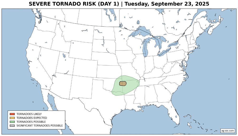
Upgrade! Portions of eastern Oklahoma and northwest Arkansas have been upgraded to an 'enhanced risk' (level 3 out of 5) for severe thunderstorms today - tonight, with a few damaging tornadoes possible.

Read their latest discussion: www.spc.noaa.gov/products/out...