⚠️ Heads up! Aches and pains will likely increase this week as we will have frequent pressure changes due to an active weather pattern. @kmbc9.bsky.social
Colder mornings are on the way as we close in on the weekend. You might notice some areas of frost with freezing lows possible Sunday morning. @kmbc9.bsky.social
Hurricane Melissa hit Jamaica with 185 mph winds as it made landfall. The storm tied for the most intense at landfall with a minimum pressure of 892 mb and ranks near the top for all-time storms in the Atlantic Basin. Sending prayers for safety and recovery. 🙏🏾 @kmbc9.bsky.social
🌀 Hurricane Melissa now ranks in the top-10 most-intense hurricanes in the Atlantic Basin. The storm was so powerful that the Air Force Reserve Hurricane Hunter aircraft team had to end their reconnaissance flight early due to severe turbulence! @kmbc9.bsky.social
🌧️ Rain is likely for Friday morning and afternoon. Some showers will linger into the evening. More rain is likely Saturday. kmbc.com/weather@kmbc9.bsky.social
🌀 We’re keeping an eye on Tropical Storm Melissa as it churns over the Caribbean Sea. The storm won’t move much over the next five days, but it could intensify into a major hurricane by early next week. @kmbc9.bsky.social
It will feel more like fall on Tuesday with highs only in the low and mid 60s. Strong, NW wind gusts could top 35 mph during the afternoon. Areas of frost (mainly north of the Metro) are possible Wednesday morning. @kmbc9.bsky.social
Staying warm and getting windy this weekend. We'll start to feel more like fall next week with highs back in the 70s. kmbc.com/weather@kmbc9.bsky.social
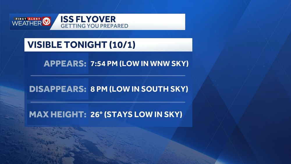
🛰️ We’ll have great weather to check out the International Space Station zipping over Kansas City. It will stay relatively low on the horizon, but you should be able to see it. It will look like a bright, fast-moving star. @kmbc9.bsky.social
4:40 PM Thursday - ⛈ Severe storms (main threat: damaging wind) are moving east of the KC Metro. Gusts up to 60 mph are possible. The severe threat will start to decrease after 8 PM. @kmbc9.bsky.social
We could use some rain as much of region has been relatively dry for the last several weeks. This dry pattern will continue into next week. kmbc.com/weather@kmbc9.bsky.social
I hope your September is off to a great start! Fall begins in just three weeks, and this month we lose daylight faster than at any other time of the year. @kmbc9.bsky.social
We set a new record low for Tuesday at 50°. This is the coolest it has been since late May. Wednesday morning will also be cool, though not quite record-breaking. @kmbc9.bsky.social
👀 We'll make a run at a record low Tuesday morning as temperatures dip into the low 50s. Some areas will likely dip into the upper 40s! @kmbc9.bsky.social
👀 We'll make a run at hitting a couple of record lows next week as temperatures dip into the low 50s. Some spots, north of the Metro, could dip into the upper 40s. @kmbc9.bsky.social
👀 Sweater weather for a few mornings next week! We could tie a record low Tuesday morning as temperatures dip into the low 50s. Some areas in northern MO/KS could fall into the upper 40s. @kmbc9.bsky.social
🌀 Erin went from a tropical storm Friday morning to a Category 5 storm today with 160 mph winds. Check out this view from inside of the eye from the NOAA Hurricane Hunters. @kmbc9.bsky.social