CoCoRaHS Station KY-JC-6
banner
cocorahskyjc6.bsky.social
CoCoRaHS Station KY-JC-6
@cocorahskyjc6.bsky.social
160 followers 340 following 2.2K posts
Community Collaborative Rain, Hail, & Snow volunteer (https://dex.cocorahs.org/stations/KY-JC-6), #CWOP volunteer & storm spotter in the Daniel Boone N.F. for NWS JKL/LMK plus operate WU PWS KKYMCKEE41 https://wunderground.com/dashboard/pws/KKYMCKEE41.
Posts Media Videos Starter Packs
OCT 22: Dr. Michael Brennan provides a LIVE update on Tropical Storm #Melissa from the National Hurricane Center: youtu.be/taj_JRUoLSs?...

Full details of the latest forecast at: Hurricanes.gov
Central Pacific Hurricane Center 2525 Correa Rd Suite 250 Honolulu, HI 96822 [email protected]
Hurricanes.gov
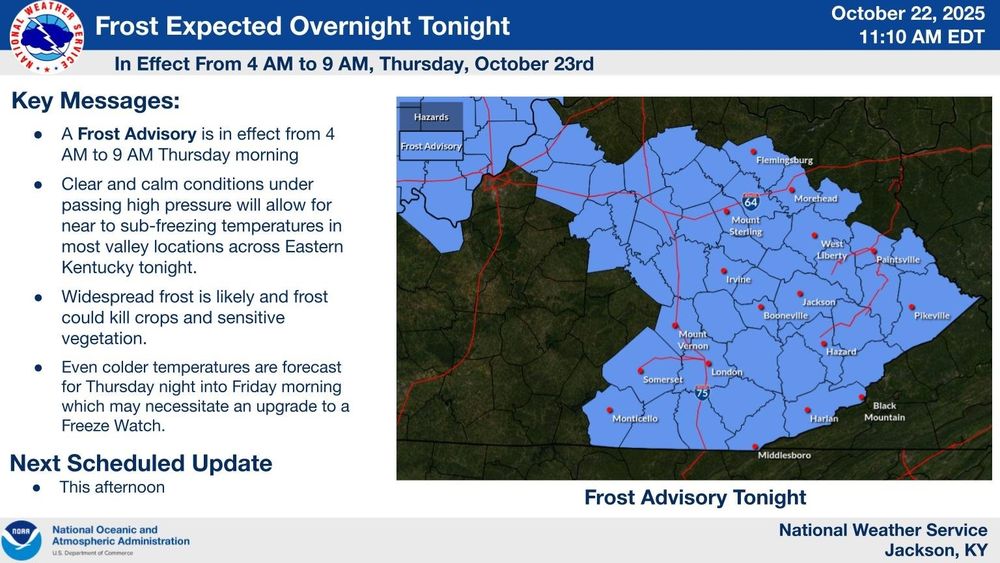
@jkl.nws-bot.us #JKL has issued a Frost Advisory for early tomorrow morning (10/23) and a Freeze Watch for Friday morning (10/24) that will affect all of Eastern Kentucky. Details 👇 at mesonet.agron.iastate.edu/vtec/?year=2... and at mesonet.agron.iastate.edu/vtec/?year=2... #ekywx
So, what's the weather going to be like in your neighborhood? #ekywx #kywx
Here is the hyperlocal forecast for the rest of today and overnight from the NWS Office in Jackson KY for @cocorahskyjc6.bsky.social. Get the hyperlocal forecast for your specific location on the NOAA Weather app at the #GooglePlay store.
@jkl.nws-bot.us #JKL issued a Hazardous Weather Outlook (HWO) at 1058 AM EDT on 22 Oct for Eastern Kentucky. A Frost Advisory will go into effect from 4 AM to 9 AM EDT on 23 Oct for all of East KY, Southern IN and a part of Central KY. Details 👉 at mesonet.agron.iastate.edu/wx/afos/p.ph... #ekywx
Clear and calm conditions overnight across portions of Southern Indiana as well as a part of Central & all of Eastern Kentucky will allow for near to sub-freezing temperatures in most valley locations. Widespread frost is likely & frost could kill crops and sensitive vegetation. #ekywx #kywx #inwx
Across Central Kentucky and Southern Indiana dry and cool weather continues with frosty mornings to end the week. See 👇 for details. #kywx #inwx
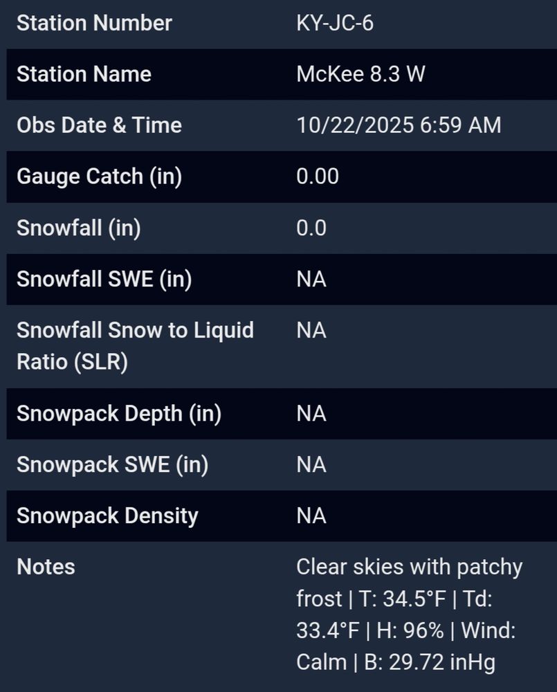
22 Oct 2025 daily observation report using a #CoCoRaHS-approved #CLIMALYTIC Tropo Rain/Snow Gauge along with a #Logia 7-in-1 #WiFi #PWS (Model LOWSC710SWB).

This location reports #wxdata 24/7/365 to #weathercloud & at wunderground.com/dashboard/pws/KKYMCKEE41 #CWOP #ShareYourWeather #ekywx #kywx
@sdf.nws-bot.us #LMK at 341 AM EDT on 22 Oct issued a Hazardous Weather Outlook (HWO) for Central Kentucky and Southern Indiana. Details 👉 at mesonet.agron.iastate.edu/wx/afos/p.ph... #kywx #inwx
@jkl.nws-bot.us #JKL at 340 AM EDT on 22 Oct issued a Hazardous Weather Outlook (HWO) for Eastern Kentucky. A Frost Advisory is in effect for the overnight hours into early Thursday morning for most of the CWA. Details 👉 at mesonet.agron.iastate.edu/wx/afos/p.ph... #ekywx #kywx
Here is the hyperlocal forecast for the next 36 hours from the NWS Office in Jackson KY for @cocorahskyjc6.bsky.social. Get the hyperlocal forecast for your specific location on the NOAA Weather app at the #GooglePlay store. So, what's the weather going to be like in your neighborhood? #ekywx #kywx
A cold front crossed Eastern Kentucky earlier today and it brought a few light showers or sprinkles along with some gusty winds. Colder air will move into the region behind the boundary and a reinforcing shot of colder air that arrives on Wed. Frost is possible several nights this week. #kywx #ekywx
Pleasant weather will continue through the end of the week across Central Kentucky and Southern Indiana. Areas of frost are expected Thursday morning and widespread frost on Friday morning. Make sure to bring in or cover plants these days. #kywx #inwx
@sdf.nws-bot.us #LMK at 333 AM EDT on 21 Oct issued a Hazardous Weather Outlook (HWO) for Central Kentucky and Southern Indiana. Details 👉 at mesonet.agron.iastate.edu/wx/afos/p.ph... #kywx #inwx
@jkl.nws-bot.us #JKL issued a Hazardous Weather Outlook (HWO) at 317 AM EDT on 21 Oct for Eastern Kentucky. Details 👉 at mesonet.agron.iastate.edu/wx/afos/p.ph... #ekywx #kywx
Interests in Puerto Rico, Hispaniola, Jamaica, and Cuba should monitor the progress of this system as there is a risk of heavy rain and flooding, strong winds, and rough surf later this week.
Visit hurricanes.gov for details. 2/2
Central Pacific Hurricane Center 2525 Correa Rd Suite 250 Honolulu, HI 96822 [email protected]
hurricanes.gov
8 am EDT update on 21 Oct 2925 from @nhc-atlc.nws-bot.us: A tropical storm is expected to form later today over the central Caribbean Sea. 1/2
21 Oct 2025 daily observation report using a #CoCoRaHS-approved #CLIMALYTIC Tropo Rain/Snow Gauge along with a #Logia 7-in-1 #WiFi #PWS (Model LOWSC710SWB).

This location reports #wxdata 24/7/365 to #weathercloud & at wunderground.com/dashboard/pws/KKYMCKEE41 #CWOP #ShareYourWeather #ekywx #kywx
Pleasant weather has materialized across Eastern Kentucky today, with cooler temps and clear skies. Another cold front approaches the region tomorrow with light rain chances, but the bigger story will be the colder temps behind it. A frost is likely in the cooler valleys by midweek! #ekywx #kywx
@nhc-atlc.nws-bot.us Tropical Weather Outlook (Monday, October 20, 2025)

NHC Science and Operations Officer Wallace Hogsett provides an update on the tropics.

x.com/NHC_Atlantic...
The rest of this week across Central KY and Southern IN continue to look cool & mostly dry. A few light showers or sprinkles will be possible early Tue. AM along a cold front, but most will stay dry. Tue. and Wed. will be breezy, with gusts to 25-30 MPH. Frost will be possible Wednesday night. #kywx
While there is significant uncertainty in the eventual track and intensity of the system, interests in Puerto Rico, Hispaniola, Jamaica, and Cuba should monitor its progress as there is a risk of heavy rain and flooding, strong winds, and rough surf later this week.

See hurricanes.gov for updates.
Central Pacific Hurricane Center 2525 Correa Rd Suite 250 Honolulu, HI 96822 [email protected]
hurricanes.gov
A tropical wave is gradually becoming better organized and is likely to become a tropical depression or storm over the central Caribbean Sea during the next few days. 1/2
Here are the 24-hour precipitation totals for the Ohio River Valley as of 8 AM EDT on October 20, 2025 #kywx #inwx